Maps for researching Scottish Woodland History
Maps provide a wealth of information about woodland history. They can also provide clues about woodland archaeology, industry, management, military use, and changes in woodland cover over time.
Timeline
This guide will explore how our maps can help you with woodland research from the earliest surviving maps of Scotland to the present day.
- What is 'woodland'?
- Ptolemy's map of Scotland, 2nd century
- Earliest surveys - late 16th century: Pont's manuscript maps and Blaeu's mapping
- 18th - early 19th centuries: Roy Military Survey, Estate maps, and County maps
- 16th century to the present day: Town plans and views
- 18th century to the present day: Travel, transport, and infrastructure maps, 1750s-1900s
- 1840s-1970: Ordnance Survey topographic mapping
- 1847-1895: OS town plans
- 1850s-1960s: OS 25-inch mapping
- 1850s-1960s: OS Six-inch mapping
- Thematic maps and air photos
- 1900-1905: Botanical Survey of Scotland
- 1931-1935: Land Utilisation Survey
- 1944-50: OS Air Photo Mosaics
- Map Collections that are not online
- Downloadable datasets
- Acknowledgements
- Further Reading
To use our map collections, you can search for digitised maps on our website, watch help videos, contact us or ask a question. You can also visit us by making an appointment to visit our Maps Reading Room in Edinburgh.
Quick Search:
- To find all maps covering a specific wood or woodland, go to the Map Finder - with Marker Pin viewer, and type a modern placename or street name in the 'Search places' box at the top left. You can also just zoom in on your place of interest on the map. Maps covering the place you are looking at are shown in the results on the right.
- To view all georeferenced maps covering a specific wood or woodland, go to the Georeferenced Maps viewer, and type a modern placename or street name in the 'Search Gazetter' box at the top left. You can also type an historic name or address in the Search OS six-inch 1888-1913 names box just below. Once you have located your wood or woodland you can then choose different dates and scales of georeferenced map using the lists in the Choose an historic map overlay panel to the lower left.
What is 'woodland'?
‘Woodland’ can mean very different types of tree cover. It has been described in different ways, and represented in different ways by various map-makers. It is important to keep these two factors in mind when viewing maps of woodland.
The following terms can all be found to describe different types of woodland vegetation:
- bushes - ‘meadow with bushes’, ‘pasture with bush’, ‘thorns and hollies’
- coppice - ‘brushwood’, ‘coppiced’, ‘copsee’
- low woodland - ‘brushwood’, ‘low brush’, ‘coppice’, ‘stumps’
- open woodland - ‘pasture and wood’, ‘tree park’, ‘wood pasture’, ‘wood and bushes’
- orchard / garden
- woodland - ‘clump of firs’, ‘plantation’, ‘planting’, ‘natural wood’
Taken, with thanks, from Muller (2019).
Map-makers have often represented woodland in different ways too, as well as taken varying degrees of interest in it. For example, a woodland-type symbol on earlier maps by Ptolemy, Pont or Blaeu may just indicate a general presence of woodland. The Roy Military Survey was often interested in woodland cover from the perspective of attack and defence, often ignoring smaller shrubs and plantations, and due to some elements of the map being ‘sketched in’, the woodland shown by Roy may not always be an exact representation even of larger woods. In contrast, estate maps, at much larger scales, and with a very clear interest in measuring land and its resources, can be accurate down to the last tree. Ordnance Survey took a greater interest in recording different types of trees and shrubs, often with greater accuracy than previous maps, but their categorisation and symbolisation changed over time.
The following terms may also be useful in what follows to describe different types of woodland:
- Ancient woodland is often assumed to have been present for at least 250 years, based on what is shown on the Roy Military Survey, and the first edition Ordnance Survey maps. Read NatureScot's guide to understanding the Scottish Ancient Woodland Inventory.
- Caledonian forest is used to describe the original prehistoric woodland, prior to significant disturbance by people or during Roman times.
- Native woodland describes woodland composed predominantly of trees and shrubs that are native in that locality.
- Plantations are woodland created by planting, usually with a regular layout of trees, and often managed for timber production.
Ptolemy's map of Scotland, 2nd century
- One of the earliest maps showing woodland in Scotland is the first plate of Europe in Ptolemy's Geographiae Libri Octo (1584).
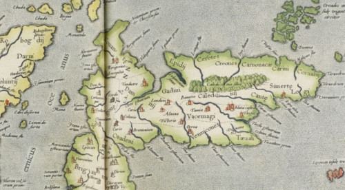
- Claudius Ptolemy was a Greek geographer, based in Alexandria (ca. A.D. 90-168) who gathered information particularly from Roman sources.
- Whilst no original copies of Ptolemy’s works have survived, many translations appeared between the 13th and 16th centuries including Mercator’s atlases in 1570 and 1584.
- The location, extent and species found in the Caledonian forest are often debated. Some researchers suggest that the Romans may well have exaggerated the large swathes of heavy forests and difficult terrain to explain their failure to conquer the local tribes. Early maps and written sources can give the impression of a large, ancient Caledonian forest, destroyed by human activity over the centuries. There is very little evidence in the field to support this, and more recent research has substantially overturned the myth of the Caledonian forest covering large parts of Roman Scotland.
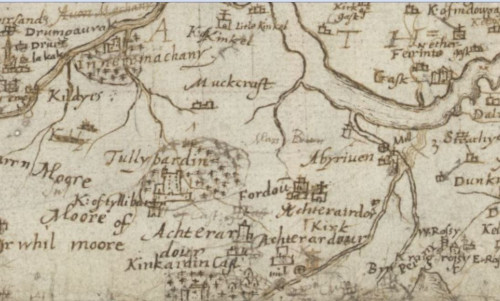
Pont's manuscript maps, 1580s-ca.1614.
- Timothy Pont’s manuscript maps provide the first graphic depiction of the size, shape and even density of woodland for many areas of Scotland. Who was Timothy Pont?
- Pont's maps often show whether woods were open or enclosed, and sometimes the means of enclosure (e.g., fence, wall, or ditch). In 1616, an Act of the Scots Parliament encouraged ‘civil and comelie’ houses with ‘policie and planting about them’. Some of these wooded policies around the great houses are clearly shown on Pont's maps, confirming that the 1616 legislation was encouraging existing practices.
- In a few areas, the types of trees in some woods, and the functions of the woodland (e.g., deer park, orchard, or a source of timber, or firewood) are also mentioned.
- Pont’s texts can add additional information about woodlands as they provide a written description of each region of Scotland. For example, the woods around Loch Maree included ‘fair and beautifull fyrrs of 60, 70, 80 feet of good and serviceable timmer for masts and raes, in other places ar great plentie of excellent great oaks, whair may be sawin out planks of 4 sumtyms 5 feet broad.’ (Pont’s texts for Loch Maree).
However:
- Pont's manuscripts only survive for parts of Scotland, and the various Gordon and Blaeu maps (see below) based on Pont's work for other areas tend to alter and sometimes considerably expand woodland, arguably for aesthetic reasons.
- On Pont's manuscripts, woodland tends to be a residual feature, and is often omitted in more densely inhabited country in favour of buildings, settlements, and their names.
- The symbols for trees on Pont's maps are inconsistent, probably not showing any distinction between deciduous or coniferous trees, and more likely to show other authors' work as well as Pont's.
- Further information on Pont's depiction of woodlands.
Blaeu's maps, 1654
- Joan Blaeu’s maps are largely based on Pont’s survey work (ca. 1583-1614), but they cover nearly all of Scotland, so they are useful for areas with no surviving Pont manuscript map. Who was Joan Blaeu?
- Blaeu’s maps are clear and easier to read but Blaeu’s engravers often simplified Pont’s manuscript to adhere to their preferred style.
- Some of the plates in Blaeu’s atlas were compiled by Robert and James Gordon and may show the physical landscape in the 1640s. Read about Robert Gordon and James Gordon.
- Blaeu’s maps confirm that enclosed woodland with planted trees existed around many of the larger country seats and royal palaces. However, the maps certainly do not record all woodland, and it may be too that tree symbols were sometimes added for aesthetic reasons to the maps. For example, the Blaeu maps based on Robert Gordon’s work, such as Extima Scotiae, were not based on a direct original survey, and the significant woodland cover shown may have been based on written sources.
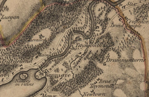
Roy Military Survey, 1747-1755.
- The first, systematic mapping of woodland in Scotland, covering all the mainland (only excluding the Northern and Western Isles).
- Features of interest to an army commander, such as tree cover and woodland can be remarkably accurate, even if they only indicate the presence of woodland.
- Scotland's Ancient Woodland Inventory uses the Roy Military Survey maps as the earliest reliable evidence for identifying Ancient Woodland.
- The designed landscapes around some of the larger country houses and estates are also particularly impressive. At specific locations such as Blair Adam, Inveraray, or Taymouth, Roy’s maps show the early beginnings of the great wave of 18th century planting. There has been speculation that some of these plantations may have been copied from estate maps rather than directly surveyed. However, on occasion, comparison with contemporary estate maps shows clear differences with plantations missed by the Roy surveyors - see the woodland at Meigle, for example (Cairt 36, Jan 2020), page 8.
- Some features and areas are more reliable than others, with woodland in some areas possibly sketched in later or even missed. The Roy map can be used as a trusted source of information if the features of interest are supported by other maps or information sources; in the absence of these other sources, it is more reliable for features of military interest. In some areas it may be that sketching woodland from the ground was more likely to exaggerate the real extent of woodland cover.
- There was no attempt to distinguish different types of trees on the Roy map.
- Further information on the Roy Military Survey of Scotland's cartographic style and content
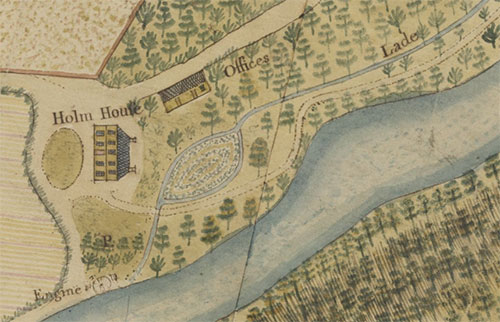
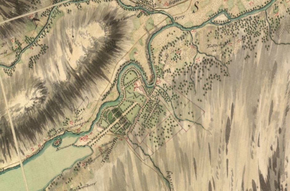
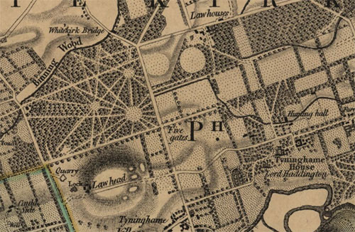
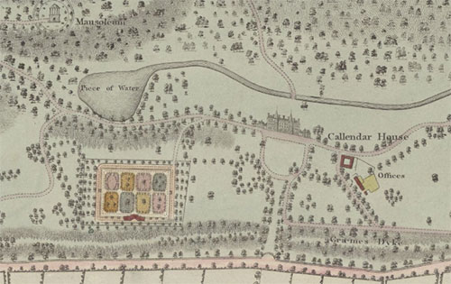
Estate and county mapping, 1750s-1850s
- Estate and county maps were often funded by landowners, who often became particularly interested in tree planting as part of wider agricultural improvement schemes.
- Most estate maps date from the 1760s to the 1830s due to an interest in improving the (agriculture and) landscape.
- Estate map surveyors were in general extremely precise given their surveying equipment and ground-based methods. The land surveying profession had a clear incentive to be accurate with their measurement of distances and directions, as well as detailed recording of landscape features. Accuracy was a matter of pride amongst surveyors.

- The surveyors who worked for the Commission for the Annexed Forfeited Estates (1755-1784) helped to set high standards in recording the landscape, including woodland. The Commission managed 13 of the largest 53 estates that had supported the Jacobites in the 1745 Rebellion, with their lands forfeited to the Crown in 1752. The Commissioners were “expressly empowered… to have the lands surveyed and plans made ‘setting forth the extent and different qualities of the grounds, the several advantages and disadvantages arising from their situation and what improvements may be made upon the same’”. The estate surveyor Peter May (ca. 1724/35 - 1795) worked for the Commission, producing very attractive and clear maps for the estates of Lovat and Cromartie, that are excellent for depicting woodland. Surveyors for the Commission such as May later worked elsewhere, and were influential in encouraging other estate surveyors to record and clearly depict woodland with great accuracy.
- Some estate plans show planned developments, including proposed tree plantings. These may be clearly described as a proposal, for example, as in the Design for a Kitchen Garden Garden, Orchard, and Flower & Winter Garden, at Salton Hall, East Lothian (1818). However, in other cases, such as at Bendochy near Coupar Angus (1751) the proposed developments of rectangular fields are shown with a tree-lined road overlain on the existing pre-improvement landscape.
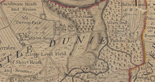
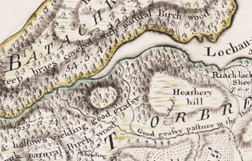
- Generally, woodland is shown on an estate map in a generic fashion, with no indication of tree age or species. Each surveyor appears to have their own recognisable tree symbols ( for example, view the maps by James Anderson, George Brown, or James Wells).
- However, on a few maps there can be an indication as to the type of woodland. In the north (especially on the Annexed Forfeited Estates maps) we often see alder, birch and fir mentioned along with the occasional mention of oak. In the south where, perhaps, newer plantations were more common it is rare that species are mentioned (as much of the early planting fashion was to put in a wide variety of trees).
- During the 19th century, it may be that some surveyors start indicating the different types of trees in their drawing with conifer and broadleaved being shown. See, for example, William Crawford’s Plan of the Estate of Newholm (1819).
- It is rare for these estate maps to show the utilisation of woodland in a way that we might expect today. It is likely that this was because timber sales were often made for specific, intermittent needs (eg. to pay debt, asset strip, or because the market was good etc.). Earlier, timber was often sold and cut over a long period of time with even comparatively small woodlands taking over ten years for a contract to be completed. The Registers of Improvement for Entailed Estates are a valuable resuorce for understanding woodland history, as well as adverts for tree sales. The markets would be fairly local with a wide variety of product being taken from the woodland. The idea of a single species woodland is mainly a 19th century idea.
- There are a few large archival collections of estate maps from a particular estate on our website. To explore these collections, see our Named Estate Map Collections.
- We hold many Estate Papers that include letters and descriptions of the estate, in addition, to our collection of Estate maps. Detailed mapping is rare before 18th century but there may be detailed written accounts of the estate held with as part of our Manuscript collections where we do not hold a map. The National Records of Scotland hold many more estate maps and related estate papers.
- Most estate papers or plans are listed under the family name of the landowners. Finding out who owned the estate, and when, can help track these down. Loretta Timperley’s Directory of Landownership in Scotland circa 1770 (1976) may be helpful. Sometimes landowner information is given in the Statistical Accounts of Scotland and on county maps (see below).
- View Estate Maps
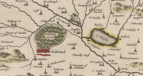
County maps, 1750s-1850s
- County maps provide an overview of woodland across a wider region, such as a county, usually in less detail than estate maps (see above).
- The number of land surveyors publishing county maps increased after 1760.
- County maps can be useful for researching plantations or managed woodlands that form part of an estate.
- How woodlands are shown on these maps varies. Some county maps show different types of woodlands using the same symbols:
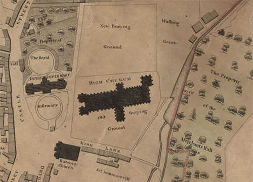
Town plans and views, 17th century to the present day.
- Town plans show detailed coverage of settlements including towns and cities. Many of the most detailed early town plans or views show trees and gardens, often in good detail.
- Although John Slezer was more interested in buildings; some of his engravings show woodlands.
- John Wood's Town Plans are clear, large-scale plans of over fifty towns in Scotland, most of them surveyed between 1818 and 1826. For several smaller towns, these are the earliest detailed plans, and many include detail of tree cover.
Travel, transport, and infrastructure maps, 1750s-1900s
- Many detailed maps which plan routes for roads, canals, or railways, often showed woodland.
- Scotland's first road atlas - George Taylor and Andrew Skinner's Survey and maps of the roads of North Britain or Scotland (1776) - recorded woodland if it was near a road.
- From the 1820s, hundreds of maps were produced of planned railways which often showed woodlands close to the route of the railway.
Ordnance Survey mapping, 1840s-present day
- Ordnance Survey maps are the earliest maps to comprehensively show tree cover across all of Scotland.
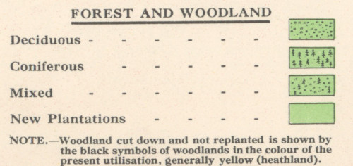
- OS maps are the earliest to systematically distinguish different tree types. Coniferous, deciduous, and mixed woodland was all clearly distinguished. Orchards were also distinguished as was “scrub” (ie. 'all shrubs and bushes including rhododendrons, brambles, gorse and broom.')
Find and compare Ordnance Survey maps:
- Find all Ordnance Survey maps for a place in our Map Finder - with Marker Pin viewer. Type a modern placename in the 'Search places' box at the top left. You can also just zoom in on your place of interest on the map. Ordnance Survey maps covering the place you are looking at are shown in the results on the right.
- Compare different dates of Ordnance Survey maps in our Side-by-side viewer. Open the Search Panel at the top left and type a modern placename, or zoom in on the map. You can then choose different dates and types of map for display using the drop-down lists above each map.
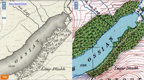
- Successive editions of mapping allow woodland change over time to be viewed. Comparing different dates of mapping to each other and to the present day is a straightforward process with georeferenced maps in our Side-by-side viewer:
OS town plans, 1850s-1890s
- OS town plans can be useful for researching trees in avenues and individual trees in towns.
- Individual trees in hedgerows are mapped on the OS town plans.
- These town plans covered 59 towns in Scotland, with towns defined as settlements with more than 4,000 inhabitants.

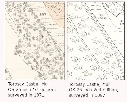
OS 25-inch mapping, 1850s-present day
- OS 25 inch to the mile maps were less detailed than OS Town Plans, but covered all inhabited parts of Scotland (around one-third of the total land area). They show the positions of free-standing trees and other woodland accurately.
- There are two editions of OS 25 inch maps for all areas that were mapped (1850s-1880s and 1890s-1900s). After these editions, urban areas or places undergoing more rapid change were surveyed again.
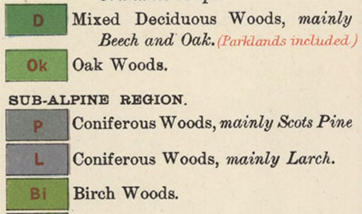
- Sometimes the symbols for the same woodland change over time when the woodland didn’t. Until 1888 birchwood was distinguished as a separate category, but after this time it was treated as deciduous. The categories changed again in 1963 as explained in Richard Oliver’s Concise Guide “...Before 1963, [the Ordnance Survey used] the following categories...on large scale maps: woods (coniferous or deciduous) fir; brushwood; furze and oziers [willow coppices used for basketmaking] ...” After 1963, these categories were changed to “...coniferous, non-coniferous, coppice (‘any non-coniferous species...cut close to the ground, except oziers’) and scrub.
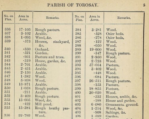
- The accompanying OS Books of Reference (sometimes also called Area Books include details of woodland and their acreages.
- Search for all OS 25 inch maps in our Map Finder - with Bounding Boxes viewer.
- Further information about OS 25 Inch to the Mile Maps of Scotland.
- Further information about OS 25 Inch to the Mile Maps of England and Wales.
- View Characteristic Sheets or legends showing symbols for woodland on OS maps
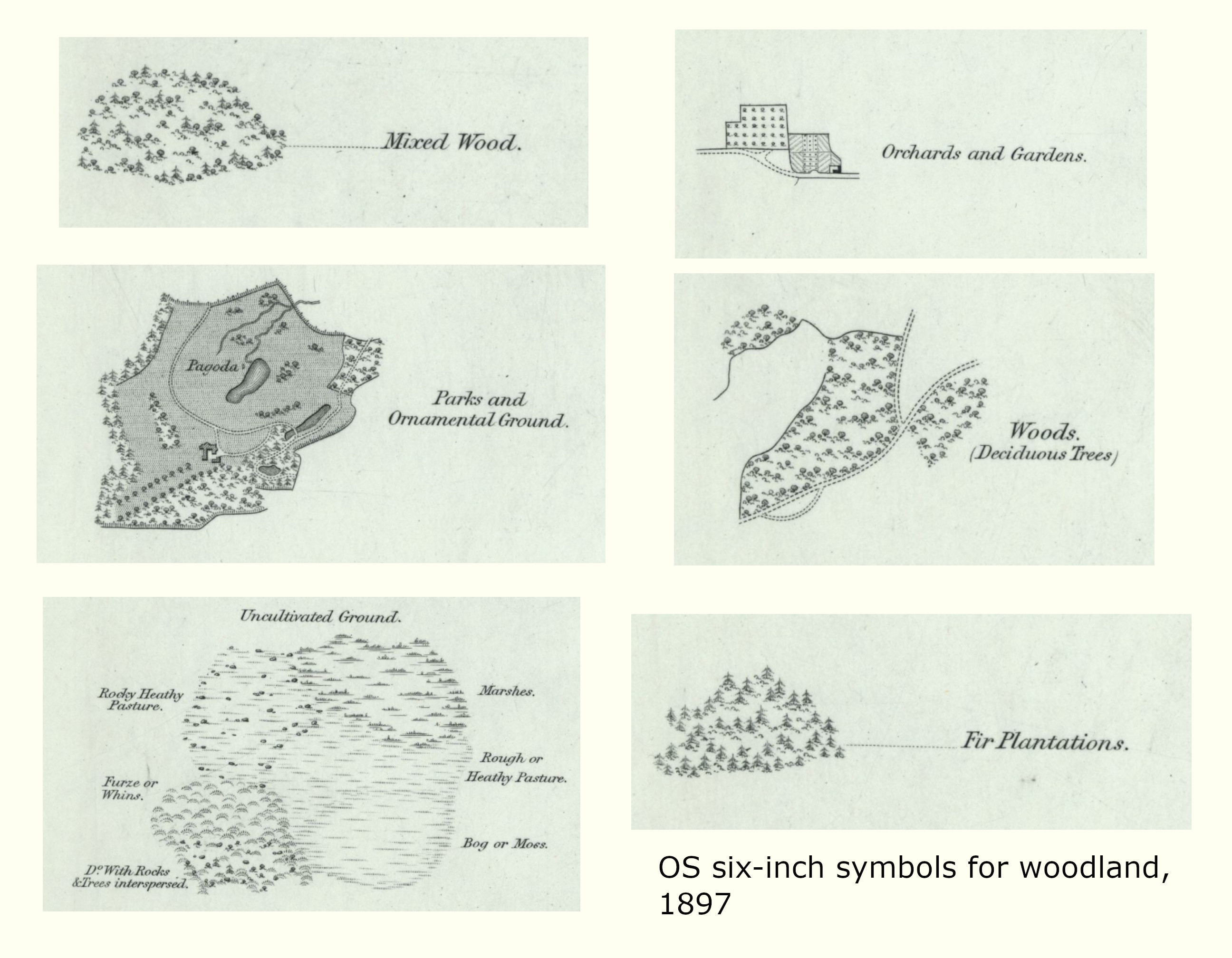
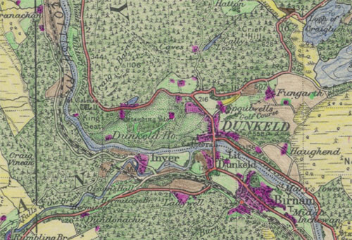
OS Six-inch mapping, 1840s-present day
- The Ordnance Survey Six-inch maps are the most detailed scale to cover all areas, and an excellent resource for showing woodland in moorland or less inhabited areas.
- Search for all OS Six-inch maps in our Map Finder - with Bounding Boxes viewer.
- View Characteristic Sheets or legends showing symbols for woodland on OS maps
- Woodland in Scotland map viewer, 1840s-1880s
Ordnance Survey smaller-scale mapping
- The Ordnance Survey smaller-scale maps at one-inch to the mile (1:63,360) are often useful for giving a wider regional overview of woodland and forestry.
- Sometimes these smaller-scale maps have updated content based on a partial revision of major landscape features including woodland, especially during the 20th century. They can therefore be useful where there are no more detailed basic-scale maps at six-inch or 25 inch to the mile. This is especially true for rural areas, where there are sometimes several decades between editions at the larger-scales.
- There were three editions of engraved one-inch maps between 1843 to 1912:
- 1st edition (1856 to 1891)
- 2nd edition (1885 to circa 1903) as Outline and Hills Editions
- 3rd edition (1903 to 1912) including a black outline edition and a coloured edition. Further information on OS One-inch maps of Scotland.
- Later editions followed including the full-colour Popular edition (1921 to ca.1930s) . Various military editions between 1933 and 1944 were produced (for instance the GSGS 3908 edition), before the edition with National Grid lines (1945 to 1948) and the Seventh Series (1952 to 1970). Further information on OS One-inch Seventh series maps.
Botanical Survey of Scotland (1900-1905)
- The Botanical Survey of Scotland was initiated through the work of the ecologist and naturalist, Dr Marcel Hardy. It recorded more details of particular types of woodland, as well as different types of pasture, including heather and heath moorland. Although limited in geographic coverage, we have several sheets from the Botanical Survey of Scotland (1900-1905) online including:
- The Botanical Survey of Scotland was published by John Bartholomew. More information about the publishing history is described in the Bartholomew Archive's Highlight - The Botanical Survey of Scotland.
- These maps were accompanied by descriptions published in the Scottish Geographical Magazine.
- Edinburgh
Smith, Robert "Botantical Survey of Scotland. I. Edinburgh District."Scottish Geographical Magazine 16.7 (1900): 385-416. - North Perthshire
Smith, Robert "Botantical Survey of Scotland. II. North Perthshire District."Scottish Geographical Magazine 16.8 (1900): 441-467. - Fife and Forfar
Smith, Robert "Botantical Survey of Scotland. III and IV. Forfar and Fife. "Scottish Geographical Magazine 21.2 (1905): 57-83.
Land Utilisation Survey, 1931-1935
- Covering all of Scotland in the 1930s, this also systematically showed woodland cover, and showed distinct types of woodland, including orchards and scrub woodland.
- The Land Utilisation Survey maps use different symbols to show different types of woodland.
- Our Scotland - Land Use viewer, allows you to compare 1930s woodland cover with woodland cover from 2015, showing the significant afforestation of Scotland between the 1930s and 1980s.
- Further information on the Land Utilisation Survey
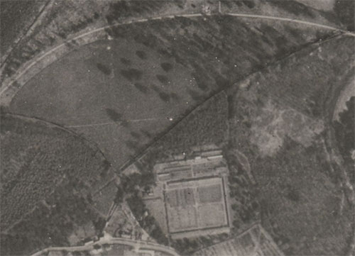
OS Air photo mosaics (1944-1950 )
- Air photo mosaics are useful in showing woodland cover in the 1940s, despite their limited geographic coverage across Scotland.
Map Collections that are not online
- Maps published within the last 50-70 years are often in copyright, and so we are unable to put them online. More information about Copyright. In-copyright maps can be consulted in our Maps Reading Room
- During the 1960s, a second Land Utilisation Survey was initiated by Dr Alice Coleman, with volunteers, school children, and university students annotating Ordnance Survey 1:10,560 scale maps with land use and related woodland information.
- You can find a wide range of records for vegetation maps through LibrarySearch including some maps covering local woodlands like vegetation maps of Cawdor Wood (1955-61). Internationally, we hold a vegetation map of the Flora Zambesiaca (1968) or maps on whole countries such as the Vegetation map of Malaysia (1958).
- We also hold some orienteering maps at 1:10,000 and 1:15,000. They can show the density of woodlands and can be useful where other large-scale maps are not available. We hold many Harveys Orienteering maps. More information can be found through LibrarySearch.
Downloadable datasets
- The Ancient Woodlands Inventory (Scotland) maps the boundaries of woods recorded as being of semi-natural origin on EITHER the 1750 Roy maps OR the 1st Edition Ordnance Survey maps of 1840-1880:
- The aim of the Native Woodland Survey of Scotland (NWSS) was to undertake a baseline survey of all native woodlands, nearly native woodlands, and Planted Ancient Woodland Sites (PAWS) in Scotland to create a woodland map linked to a dataset showing type, extent, and condition of those woods.
- The Hutton Institute completed a Land Cover Survey in 1988. The survey was aimed to be a census of land cover in Scotland. The survey used aerial photography collected from 1987 to 1989.
- Space Intelligence’s Scotland Landcover maps colour-code different types of broadleaved and coniferous woodland cover in 2019-2020, based on a semi-automatic interpretation of satellite imagery.
Acknowledgements
This page has been put together with helpful advice and contributions from Paul Bishop, Archie McConnel and Thomas Muller.
Further Reading
The following resources are a combination of other places to look for information (including other National Library of Scotland collections) and resources about woodlands and woodland history in general.
Useful woodland history resources
The National Records of Scotland hold archives from the Forestry Commission including forest histories, 1841-1974 and a census of woodlands, 1914-1959, in addition to estate papers and other useful resources. More information can be found by searching their catalogue.
Some Estate papers may be held in local archives.
Traveller’s accounts can provide more information, but their usefulness varies depending on the author’s woodland knowledge. Some traveller’s accounts can be found online:
- Recollections of a tour made in Scotland, 1803 by Dorothy Wordsworth
- Travels of Thomas Pennant, 1769
- Highlands and Islands: a nineteenth century tour by JE Bowman
Native Woodlands Discussion Group include detailed, useful information on the ecology, management and history of native woodlands in Scotland.
Useful map reading
Fleet, C., Wilkes, M., Withers, C.W.J. (2011). Scotland: Mapping the Nation. (Edinburgh: Birlinn, in association with the National Library of Scotland).
Chapter 6 on The changing countryside looks at rural mapping including woodland.
Fleet, C., Wilkes, M., Withers, C.W.J. (2016). Scotland: Mapping the Islands. (Edinburgh: Birlinn, in association with the National Library of Scotland).
Chapters 6 and 7 on Improving and Exploiting include maps showing vegetation and woods in the Scottish islands.
Gibson R. (2007). The Scottish Countryside: Its Changing Face, 1700-2000. (Edinburgh: John Donald in association with the National Archives of Scotland).
Provides an excellent overview of rural estate mapping, including maps showing plantations, woodland, gardens and forestry.
Macaulay Land Use Research Institute (1993). The Land Cover of Scotland 1988 - Final Report. (Aberdeen: MLURI ).
Mackey, E.C., Shewry, M.C. & Tudor, G.J. (1998). Land Cover Change: Scotland from the 1940s to the 1980s. (Edinburgh: SNH, The Stationery Office).
Muller, T. (2019). 'Reconstructing long-term woodland cover changes and their environmental legacy using Scottish estate plans (c.1740-1835) and GIS'. Unpublished University of Glasgow PhD. http://theses.gla.ac.uk/41074/
Muller, T. (2019). 'Using Scottish estate plans (c.1740-1835 ) to map woodland cover change over time'. Cairt 35 (July 2019), 8.
Oliver, R. (2013). Ordnance Survey maps: a concise guide for historians, 3rd ed. (London: Charles Close Society).
Smout, T.C. (2001). 'Woodland in the Maps of Pont' in The Nation Survey'd: essays on late sixteenth-century Scotland as depicted by Timothy Pont, ed. by I.C. Cunningham (East Linton: Tuckwell Press, in association with the National Library of Scotland), 77-92.
Stone, J.C. (2005). 'The cartographic signs and content of Blaeu's maps of Scotland'. Scottish Geographical Journal, 121(3), 289-296.
General woodland history
Anderson, M.L. (1967). A History of Scottish Forestry (2 vols, London & Edinburgh: Thomas Nelson and Sons).
Hopkins, J.J., & Kirby, K.J. (2007). Ecological change in British broadleaved woodland since 1947. Ibis, 149(s2): 29-40.
MacFarlane, Walter, & Mitchell, Arthur (1906). Geographical collections relating to Scotland. Made by Walter Macfarlane (Scottish History Society. Publications ; v. 51-53). Edinburgh.
Mason, W.L. (2007). Changes in the management of British forests between 1945 and 2000 and possible future trends. Ibis, 149(s2): 41-52.
Rackham, O. (2015). Woodlands. William Collins, London.
Scottish Government (2014). Scotland's Natural Forest Estate. Edinburgh, Scottish Government.
Smout, T.C. (ed.) (2003). People and woods in Scotland: a history. Edinburgh University Press, Edinburgh.
Smout, T. C., MacDonald, A. R., & Watson, F. (2005). A history of the native woodlands of Scotland, 1500-1920. Edinburgh University Press, Edinburgh.
Stewart, M. (2003). 'Using the Woods 1600-1850: The Community Resource', in People and Woods in Scotland: a history (ed. T.C. Smout). Edinburgh: Edinburgh University Press, 82-104.
Timperley, L., & Scottish Record Society (1976). A Directory of landownership in Scotland c1770 (Scottish Record Society (Series: ) ; new ser., 5). Edinburgh: Scottish Record Society.
Tipping, R. (1993). 'The History of the Scottish Forests revisited - Part 1 & 2', Reforesting Scotland, 8 & 9, 16-21, 18-21.
Tipping, R. (1994). 'The form and fate of Scotland's woodlands'. In: Proceedings of the Society of Antiquaries of Scotland (Vol. 124, pp. 1-54). National Museum of Scotland, Edinburgh.
We hope you have found some of this information new and useful. If you have further suggestions or comments, please do contact us at maps@nls.uk.
View our other Research guides.