Roy Military Survey of Scotland, 1747-1755
Cartographic style and content
According to William Roy, the map was rather a 'magnificent military sketch, than a very accurate map of the country' in which 'no geometrical exactness is to be expected, the sole object in view being, to shew remarkable things, or such as constitute the great outlines of the Country' (Roy, 1785, p. 387). It was the work of rapid reconnaissance rather than a carefully measured topographic survey.
Drawn in a pen and ink colour wash, it reflects both prevailing military colour schemes and conventions, as well as the individual draughtsmen who worked on it. Although Paul Sandby (1725-1809) was described as 'the chief draughtsman of the plan', he was assisted by Charles Tarrant, who later became a Lieutenant-General, and several others towards the conclusion of the Survey. Sandby was later celebrated as a watercolour painter and topographical artist, and was undoubtedly responsible for much of the striking hill shading on the 'original protraction'.
Military colour scheme
In practice, the scale of one inch to 1,000 yards (about 1:36,000 as a representative fraction) is large enough to show excellent detail of the landscape, particularly relief, hydrography and land-cover.
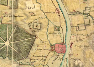
The emerging military colour scheme still influences Ordnance Survey mapping today:
- red used for buildings and man-made structures
- brown for roads
- blue-green for water
- green for woodland
- yellow for cultivated ground
- buff for moorland
Hill features are shown especially well, with brush strokes in the direction of the slope, and gradient carefully differentiated by tone. There are relatively few symbols, primarily those related to land-cover such as trees, parallel hatching for tilled land, a conventional moorland symbol, and stipple for sands or shoals. The original protraction for the south of Scotland uses the cultivated land symbol rather than the pecked lines employed on the fair copy for the north of Scotland.
Important historical source

'Without doubt, Roy's map is one of the most intriguing and at the same time infuriating documents available to the researcher into Scotland's past landscapes,', according to Whittington and Gibson (The Military Survey of Scotland 1747-1755: A Critique, 1986, p.61). Although Sir Charles Close, Director General of Ordnance Survey (1911-1922) criticised the Roy map as 'little more than an elaborate compass sketch', provided its limitations are appreciated, the Roy map is a uniquely important historical source.
Features of interest to an army commander, such as roads, rivers, the positions of villages and hamlets, as well as general land-cover and terrain are remarkably accurate. The designed landscapes around some of the larger country houses and estates are also particularly impressive.
Inconsistencies and inaccuracies
However, when moving to more specific features, the map is inconsistent and less trustworthy. The delineation of arable ground is quite inaccurate, and field boundaries are merely conventional, not reflecting their real existence on the ground.
There is no indication whatsoever of property ownership, and the detailed form of larger settlements and hamlets. Numbers of red dots do not necessarily equal the number of buildings, and there are some quite wide variations in the recording of smaller hamlets and farms, with many missing. Place names are often quite variable, sometimes reflecting local pronunciation, and recorded by surveyors who were unfamiliar with Gaelic and Scots.


There are wide disparities between the protracted and fair copies of the map, the former being more reliable, while the latter is more attractive. In geometrical terms, the methods and instruments indicate the priority of speed over accuracy in the cartography of the map, which was never intended for accurate measurement. The map can be used as a trusted source of information, especially if the features of interest are supported by other maps or information sources; in the absence of these other sources, it is more reliable for features of military interest.
View the Roy map:
- Map with gazetteers
- Full screen map - Highlands or Lowlands