Roy Military Survey of Scotland, 1747-1755
Gazetteer information page

The Roy Military Survey of Scotland transcription project took place between February and July 2022. Collectively, over 180 people worked on the project and 33,523 names were captured: 16,425 for the Highlands and 17,097 for the Lowlands.
This was a collaborative project organised by the British Library, who hold the original Roy mapping, and the National Library of Scotland.
The following sections provide further information on the Roy Gazetteer:
Search the Gazetteer
You can search in two ways:
- Search on Highlands or Lowlands names viewing distributions and places on a map
- Browse all Highlands or Lowlands names in a table, linking through to the map
Watch a video on how to search the Roy Gazetteer:
Our Roy gazetteer allows you to search all the place-names on Roy's Military Survey of Scotland. There are over 33,000 names – you'll find mountains and rivers; mills, churches and castles; towns, villages and farms.
You can search for a placename using the Search Panel at the top left of the screen. As with our other map viewers, this Search Panel allows you to search by modern placenames, National Grid References, and by county/parish. Below these, the Search Roy Highlands / Roy Lowlands Names search box allows you to search by keyword, name or part of a name.
Roy's map is in two sections – Highlands and Lowlands – and you will need to select one of these before searching. You can switch between the two by clicking on the heading just above the search box or in the Map Layer box at the bottom left of the screen.
Once you've selected the Highlands or Lowlands layer, type a name or keyword into the search box and click on the ‘Search' button (or press Enter).
This will return a list of all the names on the map that include your placename or keyword.
In the left column are the names that appear on Roy's map. Beside them are nearby or equivalent names that are shown on the Ordnance Survey 1st edition map, published in the mid-19th century. This can be useful because names and spellings can vary and change from one century to the next.
As well as the list of place-names, there is also a distribution map showing their locations throughout the country, marked in blue.
If you hover over a name in the list, you will see it highlighted in orange on the distribution map. Selecting a name in the list will take you to the relevant name on Roy's map. Clicking on a name on the map will bring up some more information in a popup box, such as the parish, county and the nearby or equivalent name that appears on the Ordnance Survey 1st edition map.
This popup box also includes the Roy Military Survey map reference, which relates to a particular map strip and sub-division. This is also shown at the bottom right of the screen (Roy Strip/Section) for the Roy Section that your cursor is over. You can also click on the Roy Map away from any placename and the Roy Map Reference will appear in a popup box.
The search panel itself is expandable by dragging the lower right corner, or you can hide it by clicking the cross at the top. Click on ‘Search placenames' to get it back at any time.
The keyword or name you have searched for is also added to the URL, so this address (and a particular search) can be copied and saved or forwarded to someone else if you want to share your search results.
You can also browse all the names that appear on Roy's map. Click on the link below the search box (Search All Names – Highlands and Lowlands) to see a full list of the names on both the Highland and Lowland layers on the Gazetteer Browse Interface - All Names page. These are listed alphabetically and clicking on any of these Roy names will take you back to the relevant section of the map.
The other link below the Roy name search box allows you to view a list of names on a particular part of the map. Zoom into an area of interest and click on Show all names on the part of the map on screen. This will return a list of just those Roy names that are shown on the part of the map that you're looking at. Again, you can click on the names in this list to view them on the Roy map.
To compare an area on Roy's map to another (later) map, use the links near the bottom right of the screen to switch to our Georeferenced maps / Side by side / Swipe viewer. These will open in a new tab so you can easily return to your search screen.
Click on Clear in the gazetteer box at any time to start a new search.
Purpose
The primary aim of the project was to record all of the names and their geographic locations on the Roy Military Survey Maps of Scotland. These names on the Roy Map were not just for settlements, but also for natural features such as glens, lochs, and mountains, as well as other man-made features such as roads, kirks and mills. The name of a place either related to or nearby the Roy name was also transcribed from the Ordnance Survey one-inch and six-inch to the mile 1st edition maps (1840s-1880s). The OS Name makes keyword searching more effective, as these OS Names are often more similar to the modern names people today may search on. The OS Name can also help to interpret the approximate location of the Roy Name. A Comments field recorded notes about the Roy or OS Name, often to help with interpretation or for explaining the linkages between the Roy and OS Name.
This page explains the format of the Roy Gazetteer - the fields used, their main content, and the transcriptions workflow that created them.
Field List
| Field Name | Description |
| ID | Unique ID for the entry. Prefixed with H (Highlands) or L (Lowlands) and a running number |
| RoyName | The exact name on the Roy Map - see Roy Map Name below for further details |
| OSName | The exact name on the OS 1st edition mapping - see Ordnance Survey Name below for further details |
| Comments | Any additional notes about the names above |
| Parish | The parish (or parishes) that the RoyName was located in (1840s-1880s) - see Parish below for further details |
| County | The county (or counties) that the RoyName was located in (1840s-1880s) |
| Reference | The Roy Military Survey sheet part or dissection(s) the name falls on - see Roy Reference for further details |
| Coordinates | The point coordinates of a polygon traced around the Roy Name. These coordinates are in latitude/longitude (WGS84 / EPSG:4326) format. |
Further Notes about the Roy Map Name and OS Name
Roy Map Name
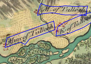
- The main aim was to record the exact name as written on the Roy Map with the same capitalisation and spacing.
- All alternative forms of names were separated by the pipe character - |
- Uncertain or missing letters or characters were indicated with ‘[...]’. In some cases, this was due to the original letters being erased or indecipherable from the Roy Map. In other cases, Roy names which straddled the strips of the original Roy Map were incomplete.

- Abbreviations were recorded as they were shown on the map, with an alternative form spelling out the abbreviation. For example, 'Wr. Rhind' was recorded as ‘Wr. Rhind | Wester Rhind'. Colons were frequently used too on the Roy map to indicate abbreviations and were recorded as they were on the map along with an expanded form, ie. ‘B: of Stanhouse | Bridge of Stanhouse’.

- The Long 'S' letter was entered as a capital S, with an alternative form including a lower case s. For example, 'BlackneSs' was recorded as 'BlackneSs | Blackness'.
- The Roy Name very occasionally included a few yogh characters (ȝ). These resembled the letter z with an extra loop descending below the line, or the number 3 with a flat top-stroke and the lower half below the line.

- The abbreviation 'Do.' for 'Ditto' was used to indicate a repeating name element from a nearby name. In these cases the abbreviation was recorded, as well as the complete name that the Ditto related to. For example, for Cotton Do beneath the placename ‘Shell hill’, this was entered as ‘Cotton Do. | Cotton Ditto | Cotton hill’. A list of common abbreviations appears below.
Roy Name - Common Abbreviations
| B | Bridge |
| C | Castle |
| E | East or Easter |
| Er | Easter |
| I | Island |
| Id | Island |
| K | Kirk |
| L | Loch |
| M | Mill |
| N | Nether or North |
| Neth | Nether |
| Nr | Nether |
| Pt | Point |
| R | River |
| S | South |
| Up | Upper |
| Upr | Upper |
| W | West or Wester or Water |
| Wr | Wester or Water |
Ordnance Survey Name
- The Ordnance Survey Name was recorded as a name in approximately the same place as the Roy name, or a place or feature (maybe a stream or crag) with a related Gaelic name - even if it was a little further away.
- OS Names were usually recorded in the same form as on the map. However, capitalised names on the OS map were recorded in a Proper Case form.
- Where the OS One-Inch and Six-Inch maps had alternative forms of the name, in general the preference was given to the OS Six-Inch name.
- In general, accents, diacritics or other extended characters from OS names were removed, as we were not able to standardise the different character encoding systems people were using. However, in some cases, these extended characters were correctly recorded, and where this was the case, these were kept. However, where these extended characters were added, an alternative form without the extended characters was also given.
Parish
- The aim of the project was to assign the parish that the Roy name was within, based on the parish boundaries shown on the Ordnance Survey first edition mapping. This was primarily to help with disambiguation for commonly occurring names, and to give an approximate location for them.
- Parishes were not recorded as part of the transcription phase, they were assigned after the transcription phase using a spatial join between the Roy transcription polygon and the parish polygon.
- Roy names close to parish boundaries were assigned the parish or county name from both sides of the boundary. This was the simplest quick way of dealing with two different problems: first, that sometimes the Roy name had no OS name equivalent (so we did not know its precise location), and second, the geographic inaccuracies of the Roy map (meaning that the Roy transcription polygons were not in their "true" geographic position.
- Some manual checking and correction work of these parish (and sometimes county) names has subsequently been done.
Roy Reference

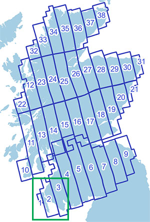
The Roy Reference is the unique identifier for the particular part of the Roy Map, incorporating a Strip Number (1-38), a Section Number (1-8) and a Part (a-f).
- The Roy Map is divided into 38 Strips of uneven size, numbered from the south-west to the north-east. Strips 1-9 cover the Lowlands and Strips 10-38 cover the Highlands. The Strips are orientated to what was magnetic north in the mid-18th century.
-
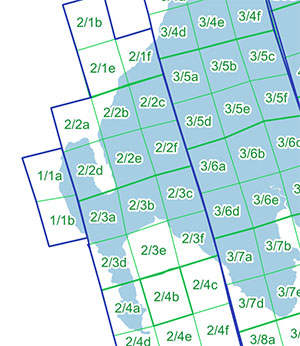
Within each Strip, there are Sections numbered from north to south. Within each Section there are six parts or dissections, with the letters a-f.

- The full Roy Reference takes the form Strip/Section Part, ie. 2/4b = Strip 2, Section 4, Part b.
- Read further information about the original copies of the Roy Map at the British Library.
Transcription workflow
- The first phase of the project asked for transcriptions of the Roy Name and OS Name from two independent people.
- Where the two names differed, these were put out for second phases of editing and correction: first for the Roy Names and secondly for the OS Names.
- A third phase tried to identify OS Names where these were missing from the original RoyName transcriptions.
- A fourth phase edited and merged the comments into a clear and simple statement.
As the phases progressed, it became increasingly easier to correct the Roy Name based on the later OS Names and Comments. Many subsequent corrections have focused on:
- ensuring data integrity - linking data to the correct polygon. This was usually due to overlapping polygons in the interface and transcriptions being initially connected to the wrong name.
- removing duplicated transcriptions.
- splitting up or uniting Roy names. Sometimes separate places were transcribed as one entry and vice-versa.
- ensuring correct expansions for abbreviations.
- ensuring correct unaccented forms of names were present.
- ensuring different names were separated by a | character.
- querying the data to reduce the number of ambiguous transcriptions with '[...]' in them.
- sorting different names into order, so that full names were followed by partial names
Download
We have made available the Roy Gazetteer for onward re-use and download. The Gazetteer data is available in CSV and GeoJSON formats for each of the Highland and Lowland regions:
These extracts were all taken on 31 July 2023.
Each of these links will open a file that can be saved locally. For the GeoJSON files, once downloaded, please change the file extension from *.js to *.geojson when opening them.
Please see our guide on Opening Map Datasets in QGIS for advice on how to use these files within the free QGIS desktop software.
You can also read details of the fields in the files above, along with Notes about the Roy Name and OS Name.
You can also view related details of the Roy dataset and onward re-use, on our Data Foundry Roy Gazetteer page.
Corrections
If you would like to suggest edits or corrections to any of the content of the Roy Gazetteer, please contact us at maps@nls.uk with the subject line 'Roy Gazetteer Correction'. We need to know, at the very least, the Roy ID number and the specific field content that needs to be corrected, following the Field List.
