Roy Military Survey of Scotland, 1747-1755
Map originals, images and bibliography

Original protractions and fair copies
Although there were original protractions made of both the maps of northern and southern Scotland, various copies were made, in particular a fair copy of northern Scotland. (No such fair copy was made for southern Scotland.)
The maps were retained by David Watson until his death in 1761, then passed briefly to the Royal Library, who lent them to William Roy sometime after 1763. From these, various reduced copies in manuscript were made. After Roy's death in 1790 all the maps were returned to the Royal Library, and transferred on to the British Museum in 1828.
The digital images
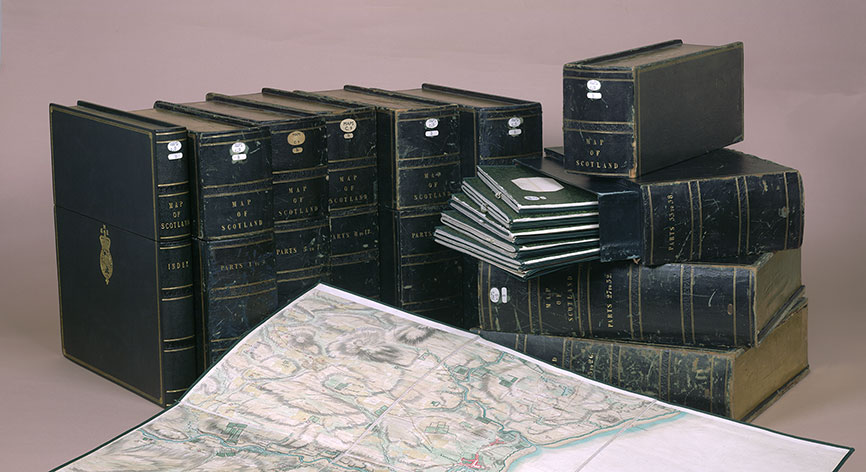
Sometime before 1844, the two sets of rolls (12 rolls as the fair copy for the north, and 10 of the original protraction for the south) were remounted as 38 sheets of unequal size (one to six further sections) Each sheet was backed on linen and dissected further into six compartments, preserved in eight slip cases to form a composite map of all of Scotland.

It is the smallest dissected part of these sheets that were photographed in the late 1980s and scanned. The 1,100 digital images were seamed together into their original strips and the strips then fitted together and rotated to a best-fit correspondence with modern outlines for ease of searching. These maps are all held in the British Library today at Maps K.Top.48.25-1.a-f.
The Roy Reference shown on this website is the unique identifier for the particular part of the Roy Map, incorporating a Strip Number (1-38), a Section Number (1-8) and a Part (a-f). Read further information about the Roy Map Reference.
Bibliography
- Anderson, Carolyn, 'Constructing the military landscape: the Board of Ordnance maps and plans of Scotland, 1689–1815', PhD diss., University of Edinburgh, 2010. View PDF online.
- Anderson, Carolyn and Christopher Fleet, Scotland: Defending the Nation. Mapping the Military Landscape (Edinburgh: Birlinn in association with the National Library of Scotland, 2018). Chapter 5. The Roy Military Survey to Fort George, Ardersier, 1746-1787.
- Bonehill, John, Anne Dulau Beveridge and Nigel Leask, Old Ways, New Roads: Travels in Scotland 1720-1832 (Edinburgh: Birlinn in association with the Hunterian, 2021). Section 1. The Theatre of War.
- Christian, Jessica, 'Paul Sandby and Scotland.' M.Litt. diss., University of St. Andrews, 1988. View PDF online.
- Fleet, Chris, 'The Roy military survey of Scotland (1747-1755)', Scottish Local History, 71, Winter 2007, 37-41.
- Fleet, Chris and Kowal, Kimberly, 'Roy Military Survey map of Scotland (1747-1755): mosaicing, geo-referencing, and web delivery', e-Perimetron , Vol. 2, No. 4, Autumn 2007, 194-208. View PDF online.
- Fleet, Christopher, Margaret Wilkes, and Charles W.J. Withers, Scotland: Mapping the Nation (Edinburgh: Birlinn in association with the National Library of Scotland, 2011). Chapter 4: Scotland occupied and defended.
- Hodson, Yolande, 'The Highland Survey 1747-1755 and the Scottish School of Cartography.' Opening up the Highlands Highland History and Archives. Scottish Records Association Conference Report Number 17, November 1991, Pages 1-4.
- Hodson, Yolande, 'The military influence on the official mapping of Britain in the eighteenth century', IMCoS Journal, 27 (1987), 21-31.
- Macdonald, George, 'General William Roy and his 'Military Antiquities of the Romans in North Britain', Archaeologia, LXVIII (1917), 161-228.
- Mallett, RJ, 'The Military Survey of Scotland 1747-1755: An Analysis Utilising the Dual Concepts of Map Form and Content.' Ph.D. diss., University of Aberdeen, 1987.
- O'Donoghue, Yolande, William Roy 1726-1790: Pioneer of the Ordnance Survey. (London: British Library, 1977)
- Roy, William, 'An Account of the Measurement of a Base on Hounslow Heath', Philosophical Transactions of the Royal Society of London, 75 (1785), 385-478.
- Roy, William, The Military Antiquities of the Romans in North Britain. (London: Society of Antiquaries of London, 1793).
- Roy, William, The Great Map : the Military Survey of Scotland 1747-55, with introductory essays by Yolande Hodson, Chris Tabraham and Charles Withers (Edinburgh: Birlinn, 2007).
- Royal Scottish Geographical Society, The Early Maps of Scotland to 1850, 3rd ed. (Edinburgh, 1973) Chapter 10
- Skelton, Raleigh A, 'The Military Survey of Scotland 1747-1755'. Scottish Geographical Magazine 83 (1967), 5-16. Reprinted as Skelton, Raleigh A. 1967. 'The Military Survey of Scotland, 1747-1755'. (Edinburgh: Royal Scottish Geographical Society, Special Publication Number 1, 1967)
- Welfare, Humphrey, General William Roy, 1726-1790: Father of the Ordnance Survey. (Edinburgh: Edinburgh University Press, 2022).
- Whittington, Graeme, and Alexander J S Gibson, The Military Survey of Scotland 1747-1755: A Critique. Historical Geography Research Series, Number 18 (Norwich: Geo Books, 1986).
View the Roy map:
- Map with gazetteers
- Full screen map - Highlands or Lowlands
Further Information
- Introduction
- Background to the Survey and William Roy
- Scope of the Survey and Field survey methods
- Cartographic style and content
- Map originals, images and bibliography
- Roy Gazetteer
