Land Utilisation Survey of Great Britain, 1931-1938
Introduction
The first systematic land utilisation survey of Great Britain was initiated in the 1930s by L. Dudley Stamp, reader and later professor of geography at the London School of Economics. The field survey work was organised through administrative counties, with Directors of Education often becoming County Organisers. Practical arrangements for the Survey were in place for most English and Welsh counties by the autumn of 1931, and for Scottish counties by the spring of 1932.
Recording
The recording of land-use was carried out by volunteers, particularly schoolchildren and students, using Ordnance Survey six-inch to the mile field sheets. Stamp saw the work not only as a valuable educational exercise and a training in citizenship, but also of value in being independent from any particular government department. The survey work was remarkably successful in completing 90% of the surveying within three years, by the autumn of 1934, although some remoter areas (particularly in Scotland) were only surveyed over the following years. The very last area to be surveyed was part of the Isle of Arran in September 1941, although all other areas were recorded by 1939. The surveys were extensively cross-checked by the team, even including Stamp with his wife as chauffeur: ‘I must have covered thousands of miles myself, often standing up on the front seat of my car with my head through the sunshine roof and a roll of six-inch maps in front of me’ (Stamp, 1948). The maps were also cross-checked with adjacent sheets when reduced to the one-inch scale.
Categories

illustrating the main categories
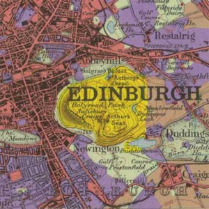
Stamp’s land utilisation survey focused on land cover rather than functional land use, with six main categories:
- meadow and permanent grass (light green)
- arable land including rotation grass (brown)
- heathland and moorland or rough hill pasture (yellow)
- forests and woodland (dark green)
- gardens (purple)
- land agriculturally unproductive / urban areas (red)
Each of these categories was in turn subdivided by the use of symbols: for example, woodland with symbols for deciduous, coniferous, or mixed trees, and gardens into different types of houses with gardens, orchards and nurseries, etc. using the Ordnance Survey’s symbolisation on the base map.
Publication

only for more arable, settled areas
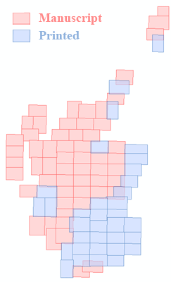
Difficulties of funding the project were a perennial problem, resulting in a long and complex publication process for the maps. All the field survey information was reduced to the one-inch to the mile scale, and coloured plates were prepared for overprinting on top of the then-current Ordnance Survey Popular edition maps. The Ordnance Survey printed the first nineteen sheets (including five for Scotland), but early in 1935 OS complained that printing the land use maps was straining their resources, and thereafter a number of private publishers were used. These included G.W. Bacon & Co., W & A.K. Johnston, Edward Stanford, and Bartholomew, with work extending through to the late 1940s. There were major losses to stocks of maps, records and printing plates during the Second World War, particularly in May 1941 when the premises of G.W. Bacon were completely destroyed, but the Survey continued, and from 1943 received official governmental support recognising the value of the maps for post-War planning.This encouraged the publication eventually of 135 maps of England and Wales, and 34 maps of Scotland, accompanied by 92 written County Reports. Stamp was never able to fund the publication of 57 sheets covering upland areas of Scotland. Manuscript maps for these areas were deposited with the Royal Geographical Society, from which hand-coloured copies were made in the 1960s by the National Library of Scotland. These differences between the manuscript and printed maps, as well as the range of printers and different papers used during the War result in contrasts in colour between the sheets, even though all follow the basic categorisation.
Other land utilisation maps
There were other land utilisation maps of Scotland before and after the Stamp survey, but they either were far less detailed, or unsuccessful in achieving comprehensive coverage. John George Bartholomew (1860-1920) took a keen interest in thematic mapping, and teamed up with the ornithologist and naturalist John Harvie Brown to publish the Naturalist’s Map of Scotland (1893). Bartholomew’s Survey Atlases of Scotland also included a small-scale map of Land Surface Features (1912). The pioneering Scottish botanists Robert and William Smith used Bartholomew base mapping for botanical maps of selected areas, and encouraged Marcel Hardy's Botanical Survey of Scotland map (1906). This map was the first to show plant relationships in Scotland over a wide area, using the 10 mile to the inch scale (1:633,360), and was used in part for the compilation of the Types of Farming (1944) map, as part of the Planning Maps Series (1944-1960). Stamp’s team were also responsible for the reduction of the Land Utilisation Survey one-inch maps to the 10 mile to the inch scale for the Land Utilisation maps (1945) in this series too.
In the 1960s, a Second Land Utilisation Survey was initiated with Dudley Stamp’s approval under the direction of Dr Alice Coleman at King’s College London, using the new 1:25,000 Provisional edition maps as a base, and a more detailed set of 64 land-use categories. In spite of significant volunteer surveying, due to funding problems, less than 15% of the country was covered with a published map.
References
Stamp L.D. (1931). 'The Land Utilization Survey of Britain'. The Geographical Journal, 78, 40-47.
Stamp L.D. (1948, with later editions in 1950 and 1962). The Land of Britain: its use and misuse (Longman, London).
