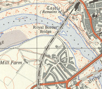
Ordnance Survey, 1:25,000 maps of Great Britain - 1945-1973

The 1:25,000 'Provisional edition' or 'First Series', was Ordnance Survey's first civilian map series at this medium scale, the forerunner of the modern Explorer and Outdoor Leisure maps. By 1956 it covered 80% of Great Britain, everywhere apart from the Scottish Highlands and Islands. The series is useful for showing rural and urban areas in much greater detail than the standard one-inch to the mile (1:63,360) maps.
See also the Outline series (1945-1973) and Administrative Areas series (1945-1968), as well as the Second Series / Pathfinder series (for maps after 1964).
- View all 1:25,000 maps with a graphic index
- View the maps as a seamless layer on a satellite image base
- Browse list by sheet number:
NC76-NZ90 | SD08-SZ99 | TA00-TV69 | Special Sheet - The Antonine Wall (1969)
Further information on this group of maps.
