Mapmakers
Your search for Brown, George returned 138 records.
Ordered chronologically (undated items first).
| Field | Content | |
|---|---|---|
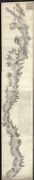
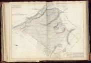
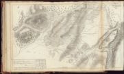
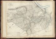
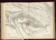
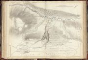
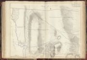
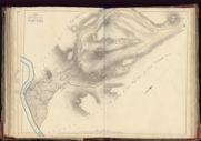
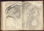
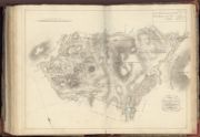
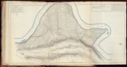
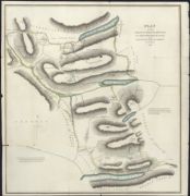
| Name: | Brown, George, 1747-1816 | |
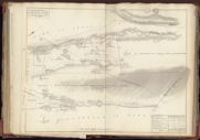
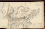
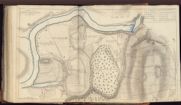
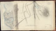
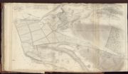
| Title: | Plan of intended road from Loch Inver by the Portenleick Ferry. Surveyed by George Brown. With estimate of cost (separate), 1793. | |
| Imprint: | 1793 | |
| Zoom Into Map: | Click on the map to view in greater detail. | |
| Field | Content | |
|---|---|---|
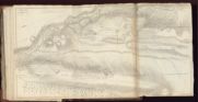
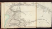
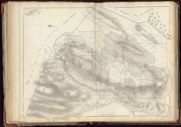
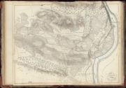
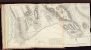
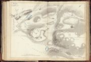
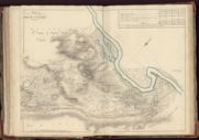
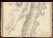
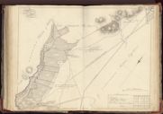
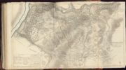
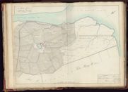
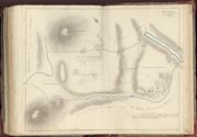
| Name: | Brown, George, 1747-1816 | |
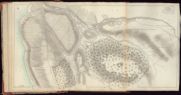
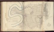
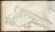
| Title: | Boblainey and Clunevackie | |
| Imprint: | Surveyed: 1798-1800 | |
| Zoom Into Map: | Click on the map to view in greater detail. | |
| Field | Content | |
|---|---|---|
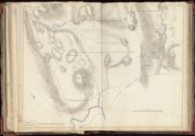
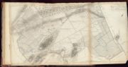
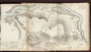
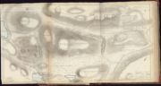
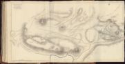
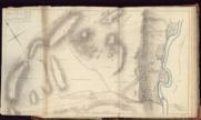
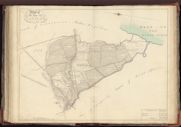
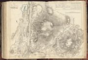
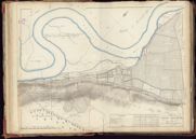
| Name: | Brown, George, 1747-1816 | |
| Title: | Part of Clunvackie | |
| Imprint: | Surveyed: 1798-1800 | |
| Zoom Into Map: | Click on the map to view in greater detail. | |
| Field | Content | |
|---|---|---|
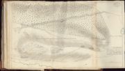
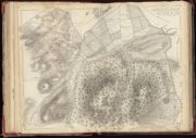
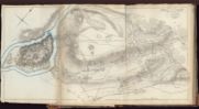
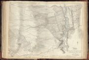
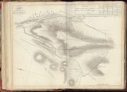
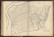
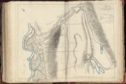
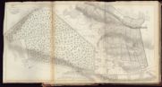
| Name: | Brown, George, 1747-1816 | |
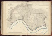
| Title: | Drumnagariachan and Plantation of Boblainey | |
| Imprint: | Surveyed: 1798-1800 | |
| Zoom Into Map: | Click on the map to view in greater detail. | |
| Field | Content | |
|---|---|---|
| Name: | Brown, George, 1747-1816 | |
| Title: | Glebe of Kiltarliity, Ardrynich, Tomnachroich | |
| Imprint: | Surveyed: 1798-1800 | |
| Zoom Into Map: | Click on the map to view in greater detail. | |
| Field | Content | |
|---|---|---|
| Name: | Brown, George, 1747-1816 | |
| Title: | Englistown and Keanlay | |
| Imprint: | Surveyed: 1798-1800 | |
| Zoom Into Map: | Click on the map to view in greater detail. | |
| Field | Content | |
|---|---|---|
| Name: | Brown, George, 1747-1816 | |
| Title: | Muckle Phoineas, Craggan, Balla Craggan, Connon Bank & Wester Moniak | |
| Imprint: | Surveyed: 1798-1800 | |
| Zoom Into Map: | Click on the map to view in greater detail. | |
| Field | Content | |
|---|---|---|
| Name: | Brown, George, 1747-1816 | |
| Title: | Cabrich, Milifiack & Lyne | |
| Imprint: | Surveyed: 1798-1800 | |
| Zoom Into Map: | Click on the map to view in greater detail. | |
| Field | Content | |
|---|---|---|
| Name: | Brown, George, 1747-1816 | |
| Title: | Easter Clune | |
| Imprint: | Surveyed: 1798-1800 | |
| Zoom Into Map: | Click on the map to view in greater detail. | |
| Field | Content | |
|---|---|---|
| Name: | Brown, George, 1747-1816 | |
| Title: | Wester Clune | |
| Imprint: | Surveyed: 1798-1800 | |
| Zoom Into Map: | Click on the map to view in greater detail. | |
| Field | Content | |
|---|---|---|
| Name: | Brown, George, 1747-1816 | |
| Title: | Clunes | |
| Imprint: | Surveyed: 1798-1800 | |
| Zoom Into Map: | Click on the map to view in greater detail. | |
| Field | Content | |
|---|---|---|
| Name: | Brown, George, 1747-1816 | |
| Title: | Easter & Wester Dunys | |
| Imprint: | Surveyed: 1798-1800 | |
| Zoom Into Map: | Click on the map to view in greater detail. | |
| Field | Content | |
|---|---|---|
| Name: | Brown, George, 1747-1816 | |
| Title: | Plan of the Farm of Castle Duny | |
| Imprint: | Surveyed: 1798-1800 | |
| Zoom Into Map: | Click on the map to view in greater detail. | |
| Field | Content | |
|---|---|---|
| Name: | Brown, George, 1747-1816 | |
| Title: | Finellan, Lurg & Tyachroichk | |
| Imprint: | Surveyed: 1798-1800 | |
| Zoom Into Map: | Click on the map to view in greater detail. | |
| Field | Content | |
|---|---|---|
| Name: | Brown, George, 1747-1816 | |
| Title: | Farms of Carabin, Ruttal & Easter & Wester Culachans | |
| Imprint: | Surveyed: 1798-1800 | |
| Zoom Into Map: | Click on the map to view in greater detail. | |
| Field | Content | |
|---|---|---|
| Name: | Brown, George, 1747-1816 | |
| Title: | Farms of Cottertown, Auchnamoin, Saw Mill & Others | |
| Imprint: | Surveyed: 1798-1800 | |
| Zoom Into Map: | Click on the map to view in greater detail. | |
| Field | Content | |
|---|---|---|
| Name: | Brown, George, 1747-1816 | |
| Title: | Fopachie and Kirktown | |
| Imprint: | Surveyed: 1798-1800 | |
| Zoom Into Map: | Click on the map to view in greater detail. | |
| Field | Content | |
|---|---|---|
| Name: | Brown, George, 1747-1816 | |
| Title: | Farm of Lone Buie & Improvements in the Moor of Castle Duny | |
| Imprint: | Surveyed: 1798-1800 | |
| Zoom Into Map: | Click on the map to view in greater detail. | |
| Field | Content | |
|---|---|---|
| Name: | Brown, George, 1747-1816 | |
| Title: | Auchnacloich | |
| Imprint: | Surveyed: 1798-1800 | |
| Zoom Into Map: | Click on the map to view in greater detail. | |
| Field | Content | |
|---|---|---|
| Name: | Brown, George, 1747-1816 | |
| Title: | Ardindrain & Glaick Vea (or Birch How) | |
| Imprint: | Surveyed: 1800 | |
| Zoom Into Map: | Click on the map to view in greater detail. | |
| Field | Content | |
|---|---|---|
| Name: | Brown, George, 1747-1816 | |
| Title: | Fanblair | |
| Imprint: | Surveyed: 1798-1800 | |
| Zoom Into Map: | Click on the map to view in greater detail. | |
| Field | Content | |
|---|---|---|
| Name: | Brown, George, 1747-1816 | |
| Title: | Inchberrie & Pheybowie | |
| Imprint: | Surveyed: 1798-1800 | |
| Zoom Into Map: | Click on the map to view in greater detail. | |
| Field | Content | |
|---|---|---|
| Name: | Brown, George, 1747-1816 | |
| Title: | Ardblair | |
| Imprint: | Surveyed: 1800 | |
| Zoom Into Map: | Click on the map to view in greater detail. | |
| Field | Content | |
|---|---|---|
| Name: | Brown, George, 1747-1816 | |
| Title: | Hill Pasture of Ardblair | |
| Imprint: | Surveyed: 1798-1800 | |
| Zoom Into Map: | Click on the map to view in greater detail. | |
| Field | Content | |
|---|---|---|
| Name: | Brown, George, 1747-1816 | |
| Title: | Culmaskiach | |
| Imprint: | Surveyed: 1798-1800 | |
| Zoom Into Map: | Click on the map to view in greater detail. | |
| Field | Content | |
|---|---|---|
| Name: | Brown, George, 1747-1816 | |
| Title: | Hill Pasture of Culmaskiach | |
| Imprint: | Surveyed: 1798-1800 | |
| Zoom Into Map: | Click on the map to view in greater detail. | |
| Field | Content | |
|---|---|---|
| Name: | Brown, George, 1747-1816 | |
| Title: | Farm of Auchastruie | |
| Imprint: | Surveyed: 1798-1800 | |
| Zoom Into Map: | Click on the map to view in greater detail. | |
| Field | Content | |
|---|---|---|
| Name: | Brown, George, 1747-1816 | |
| Title: | Farms of Convin, Ballendhor, Doulanach, Brae Arkie & Ty Varren | |
| Imprint: | Surveyed: 1798-1800 | |
| Zoom Into Map: | Click on the map to view in greater detail. | |
| Field | Content | |
|---|---|---|
| Name: | Brown, George, 1747-1816 | |
| Title: | Farm of Craggan Pyallie and Moor of Convin | |
| Imprint: | Surveyed: 1798-1800 | |
| Zoom Into Map: | Click on the map to view in greater detail. | |
| Field | Content | |
|---|---|---|
| Name: | Brown, George, 1747-1816 | |
| Title: | Wester Eskadale | |
| Imprint: | Surveyed: 1798-1800 | |
| Zoom Into Map: | Click on the map to view in greater detail. | |
| Field | Content | |
|---|---|---|
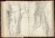
| Name: | Brown, George, 1747-1816 | |
| Title: | Common Hill and Moor Ground, with part of Wester Eskadale | |
| Imprint: | Surveyed: 1798-1800 | |
| Zoom Into Map: | Click on the map to view in greater detail. | |
| Field | Content | |
|---|---|---|
| Name: | Brown, George, 1747-1816 | |
| Title: | Blair na hanochrie | |
| Imprint: | Surveyed: 1798-1800 | |
| Zoom Into Map: | Click on the map to view in greater detail. | |
| Field | Content | |
|---|---|---|
| Name: | Brown, George, 1747-1816 | |
| Title: | Farm of Midd Main | |
| Imprint: | Surveyed: 1798-1800 | |
| Zoom Into Map: | Click on the map to view in greater detail. | |
| Field | Content | |
|---|---|---|
| Name: | Brown, George, 1747-1816 | |
| Title: | Glassfield & Crunish | |
| Imprint: | Surveyed: 1798-1800 | |
| Zoom Into Map: | Click on the map to view in greater detail. | |
| Field | Content | |
|---|---|---|
| Name: | Brown, George, 1747-1816 | |
| Title: | Creelevan & Carnech | |
| Imprint: | Surveyed: 1798-1800 | |
| Zoom Into Map: | Click on the map to view in greater detail. | |
| Field | Content | |
|---|---|---|
| Name: | Brown, George, 1747-1816 | |
| Title: | Artlican (Carnech) | |
| Imprint: | Surveyed: 1798-1800 | |
| Zoom Into Map: | Click on the map to view in greater detail. | |
| Field | Content | |
|---|---|---|
| Name: | Brown, George, 1747-1816 | |
| Title: | Clychnahoan, Shanavall, Craigdu, Trecarach Crocknashalavoch | |
| Imprint: | Surveyed: 1798-1800 | |
| Zoom Into Map: | Click on the map to view in greater detail. | |
| Field | Content | |
|---|---|---|
| Name: | Brown, George, 1747-1816 | |
| Title: | Farms of Ardnagrask & Knock na Buie | |
| Imprint: | Surveyed: 1798-1800 | |
| Zoom Into Map: | Click on the map to view in greater detail. | |
| Field | Content | |
|---|---|---|
| Name: | Brown, George, 1747-1816 | |
| Title: | The Farm of Lettoch | |
| Imprint: | Surveyed: 1798-1800 | |
| Zoom Into Map: | Click on the map to view in greater detail. | |
| Field | Content | |
|---|---|---|
| Name: | Brown, George, 1747-1816 | |
| Title: | Barn Yards, Tomich & Tynallan | |
| Imprint: | Surveyed: 1798-1800 | |
| Zoom Into Map: | Click on the map to view in greater detail. | |
| Field | Content | |
|---|---|---|
| Name: | Brown, George, 1747-1816 | |
| Title: | Beauly, Crowyard and Wellhouse | |
| Imprint: | Surveyed: 1798-1800 | |
| Zoom Into Map: | Click on the map to view in greater detail. | |
| Field | Content | |
|---|---|---|
| Name: | Brown, George, 1747-1816 | |
| Title: | Tywick & Bridge End | |
| Imprint: | Surveyed: 1798-1800 | |
| Zoom Into Map: | Click on the map to view in greater detail. | |
| Field | Content | |
|---|---|---|
| Name: | Brown, George, 1747-1816 | |
| Title: | Common Moor of Pharnaway | |
| Imprint: | Surveyed: 1798-1800 | |
| Zoom Into Map: | Click on the map to view in greater detail. | |
| Field | Content | |
|---|---|---|
| Name: | Brown, George, 1747-1816 | |
| Title: | The Farms of Grome, Kaun-a-Gro & Corff House | |
| Imprint: | Surveyed: 1798-1800 | |
| Zoom Into Map: | Click on the map to view in greater detail. | |
| Field | Content | |
|---|---|---|
| Name: | Brown, George, 1747-1816 | |
| Title: | Farms of Annet & Teafrish | |
| Imprint: | Surveyed: 1798-1800 | |
| Zoom Into Map: | Click on the map to view in greater detail. | |
| Field | Content | |
|---|---|---|
| Name: | Brown, George, 1747-1816 | |
| Title: | Alter, Ballblair, Craig Scorry, Craggan | |
| Imprint: | Surveyed: 1798-1800 | |
| Zoom Into Map: | Click on the map to view in greater detail. | |
| Field | Content | |
|---|---|---|
| Name: | Brown, George, 1747-1816 | |
| Title: | Farms of Tychnick, Inchruarie, Reinavaal and the improvements of Relick | |
| Imprint: | Surveyed: 1798-1800 | |
| Zoom Into Map: | Click on the map to view in greater detail. | |
| Field | Content | |
|---|---|---|
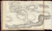
| Name: | Brown, George, 1747-1816 | |
| Title: | Common Moor and Moss Ground, with property in dispute with Chisholm of Chisholm | |
| Imprint: | Surveyed: 1798-1800 | |
| Zoom Into Map: | Click on the map to view in greater detail. | |
| Field | Content | |
|---|---|---|
| Name: | Brown, George, 1747-1816 | |
| Title: | Manse of Kilmorack, Torgormack and the Improvements thereof | |
| Imprint: | Surveyed: 1798-1800 | |
| Zoom Into Map: | Click on the map to view in greater detail. | |
| Field | Content | |
|---|---|---|
| Name: | Brown, George, 1747-1816 | |
| Title: | Leinassie, Fairly, Torrin Auchtin, Knock-Bain & Kyle-na-Clea | |
| Imprint: | Surveyed: 1798-1800 | |
| Zoom Into Map: | Click on the map to view in greater detail. | |
| Field | Content | |
|---|---|---|
| Name: | Brown, George, 1747-1816 | |
| Title: | Part of the Grazing of Fairly | |
| Imprint: | Surveyed: 1798-1800 | |
| Zoom Into Map: | Click on the map to view in greater detail. | |
| Field | Content | |
|---|---|---|
| Name: | Brown, George, 1747-1816 | |
| Title: | Part of the Grazing of Fairly | |
| Imprint: | Surveyed: 1798-1800 | |
| Zoom Into Map: | Click on the map to view in greater detail. | |
| Field | Content | |
|---|---|---|
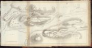
| Name: | Brown, George, 1747-1816 | |
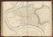
| Title: | The Eastern Division of Urchany, called Coul-na-Bodach | |
| Imprint: | Surveyed: 1798-1800 | |
| Zoom Into Map: | Click on the map to view in greater detail. | |
| Field | Content | |
|---|---|---|
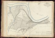
| Name: | Brown, George, 1747-1816 | |
| Title: | Easter Lovat | |
| Imprint: | Surveyed: 1798-1800 | |
| Zoom Into Map: | Click on the map to view in greater detail. | |
| Field | Content | |
|---|---|---|
| Name: | Brown, George, 1747-1816 | |
| Title: | The Wester Division of Urchany, called Gillie Phaeton | |
| Imprint: | Surveyed: 1798-1800 | |
| Zoom Into Map: | Click on the map to view in greater detail. | |
| Field | Content | |
|---|---|---|
| Name: | Brown, George, 1747-1816 | |
| Title: | Part of Easter Crochill | |
| Imprint: | Surveyed: 1798-1800 | |
| Zoom Into Map: | Click on the map to view in greater detail. | |
| Field | Content | |
|---|---|---|
| Name: | Brown, George, 1747-1816 | |
| Title: | Part of Easter Crochill possessed by James Fraser | |
| Imprint: | Surveyed: 1798-1800 | |
| Zoom Into Map: | Click on the map to view in greater detail. | |
| Field | Content | |
|---|---|---|
| Name: | Brown, George, 1747-1816 | |
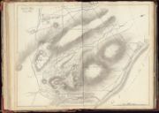
| Title: | Hill Pastures of Po | |
| Imprint: | Surveyed: 1798-1800 | |
| Zoom Into Map: | Click on the map to view in greater detail. | |
| Field | Content | |
|---|---|---|
| Name: | Brown, George, 1747-1816 | |
| Title: | Lovat, Ballblair & Lovat Croft | |
| Imprint: | Surveyed: 1798-1800 | |
| Zoom Into Map: | Click on the map to view in greater detail. | |
| Field | Content | |
|---|---|---|
| Name: | Brown, George, 1747-1816 | |
| Title: | Kirkhill, Donaldstown & the Plantation of Blair na Kylich | |
| Imprint: | Surveyed: 1798-1800 | |
| Zoom Into Map: | Click on the map to view in greater detail. | |
| Field | Content | |
|---|---|---|
| Name: | Brown, George, 1747-1816 | |
| Title: | Easter & Wester Dunballochs | |
| Imprint: | Surveyed: 1798-1800 | |
| Zoom Into Map: | Click on the map to view in greater detail. | |
| Field | Content | |
|---|---|---|
| Name: | Brown, George, 1747-1816 | |
| Title: | [Inscription relating to Deposition, 29 October 1809] | |
| Imprint: | Surveyed: 1798-1800 | |
| Zoom Into Map: | Click on the map to view in greater detail. | |
| Field | Content | |
|---|---|---|
| Name: | Brown, George, 1747-1816 | |
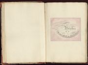
| Title: | [Blank Opening] | |
| Imprint: | Surveyed: 1798-1800 | |
| Zoom Into Map: | Click on the map to view in greater detail. | |
| Field | Content | |
|---|---|---|
| Name: | Brown, George, 1747-1816 | |
| Title: | [Blank Opening] | |
| Imprint: | Surveyed: 1798-1800 | |
| Zoom Into Map: | Click on the map to view in greater detail. | |
| Field | Content | |
|---|---|---|
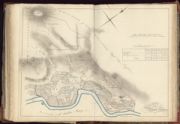
| Name: | Brown, George, 1747-1816 | |
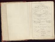
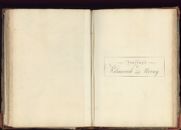
| Title: | [Title Page] A Book of Plans or Sheet Maps of the Lordship of Lovat and others… belonging to… Archibald Fraser… made out of accurate surveys taken 1798-99 & 1800 by George Brown | |
| Imprint: | Surveyed: 1798-1800 | |
| Zoom Into Map: | Click on the map to view in greater detail. | |
| Field | Content | |
|---|---|---|
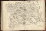
| Name: | Brown, George, 1747-1816 | |
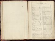
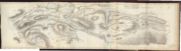
| Title: | [Index 1] - Parishes of Pharnaway, Kirkhill, Kiltarlity, and Kilmorack | |
| Imprint: | Surveyed: 1798-1800 | |
| Zoom Into Map: | Click on the map to view in greater detail. | |
| Field | Content | |
|---|---|---|
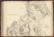
| Name: | Brown, George, 1747-1816 | |
| Title: | [Index 2] - Parishes of Kilmorack and Urray | |
| Imprint: | Surveyed: 1798-1800 | |
| Zoom Into Map: | Click on the map to view in greater detail. | |
| Field | Content | |
|---|---|---|
| Name: | Brown, George, 1747-1816 | |
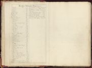
| Title: | Parishes of Pharnaway and Kirkhill | |
| Imprint: | Surveyed: 1798-1800 | |
| Zoom Into Map: | Click on the map to view in greater detail. | |
| Field | Content | |
|---|---|---|
| Name: | Brown, George, 1747-1816 | |
| Title: | No 1. Contents of Englistown and Keanlay | |
| Imprint: | Surveyed: 1798-1800 | |
| Zoom Into Map: | Click on the map to view in greater detail. | |
| Field | Content | |
|---|---|---|
| Name: | Brown, George, 1747-1816 | |
| Title: | No 2. Contents - Kirktown contains Phopachie | |
| Imprint: | Surveyed: 1798-1800 | |
| Zoom Into Map: | Click on the map to view in greater detail. | |
| Field | Content | |
|---|---|---|
| Name: | Brown, George, 1747-1816 | |
| Title: | [Blank Opening] (top right: No. 3) | |
| Imprint: | Surveyed: 1798-1800 | |
| Zoom Into Map: | Click on the map to view in greater detail. | |
| Field | Content | |
|---|---|---|
| Name: | Brown, George, 1747-1816 | |
| Title: | [Blank Opening] (top right: No. 4) | |
| Imprint: | Surveyed: 1798-1800 | |
| Zoom Into Map: | Click on the map to view in greater detail. | |
| Field | Content | |
|---|---|---|
| Name: | Brown, George, 1747-1816 | |
| Title: | [Blank Opening] (top right: No. 5) | |
| Imprint: | Surveyed: 1798-1800 | |
| Zoom Into Map: | Click on the map to view in greater detail. | |
| Field | Content | |
|---|---|---|
| Name: | Brown, George, 1747-1816 | |
| Title: | [Blank Opening] (top right: No. 6) | |
| Imprint: | Surveyed: 1798-1800 | |
| Zoom Into Map: | Click on the map to view in greater detail. | |
| Field | Content | |
|---|---|---|
| Name: | Brown, George, 1747-1816 | |
| Title: | [Blank Opening] (No. 7 written top right) | |
| Imprint: | Surveyed: 1798-1800 | |
| Zoom Into Map: | Click on the map to view in greater detail. | |
| Field | Content | |
|---|---|---|
| Name: | Brown, George, 1747-1816 | |
| Title: | [Blank Opening] (top right: No. 8) | |
| Imprint: | Surveyed: 1798-1800 | |
| Zoom Into Map: | Click on the map to view in greater detail. | |
| Field | Content | |
|---|---|---|
| Name: | Brown, George, 1747-1816 | |
| Title: | Contents. Kirkhill, Donaldstoun, | |
| Imprint: | Surveyed: 1798-1800 | |
| Zoom Into Map: | Click on the map to view in greater detail. | |
| Field | Content | |
|---|---|---|
| Name: | Brown, George, 1747-1816 | |
| Title: | Title: Parish of Kiltarlity | |
| Imprint: | Surveyed: 1798-1800 | |
| Zoom Into Map: | Click on the map to view in greater detail. | |
| Field | Content | |
|---|---|---|
| Name: | Brown, George, 1747-1816 | |
| Title: | No 10. Contents. Muckle Phoineas, Craggan, Balla Craggan, Connon Bank, Wester Moniak | |
| Imprint: | Surveyed: 1798-1800 | |
| Zoom Into Map: | Click on the map to view in greater detail. | |
| Field | Content | |
|---|---|---|
| Name: | Brown, George, 1747-1816 | |
| Title: | No 11. Contents. Cabrich, Milifiack, Lyne, Knockbain | |
| Imprint: | Surveyed: 1798-1800 | |
| Zoom Into Map: | Click on the map to view in greater detail. | |
| Field | Content | |
|---|---|---|
| Name: | Brown, George, 1747-1816 | |
| Title: | [Blank Opening] (top right: No. 12) | |
| Imprint: | Surveyed: 1798-1800 | |
| Zoom Into Map: | Click on the map to view in greater detail. | |
| Field | Content | |
|---|---|---|
| Name: | Brown, George, 1747-1816 | |
| Title: | [Blank Opening] (top right: No. 13) | |
| Imprint: | Surveyed: 1798-1800 | |
| Zoom Into Map: | Click on the map to view in greater detail. | |
| Field | Content | |
|---|---|---|
| Name: | Brown, George, 1747-1816 | |
| Title: | [Blank Opening] (top right: No. 14) | |
| Imprint: | Surveyed: 1798-1800 | |
| Zoom Into Map: | Click on the map to view in greater detail. | |
| Field | Content | |
|---|---|---|
| Name: | Brown, George, 1747-1816 | |
| Title: | [Blank Opening] (top right: No. 15) | |
| Imprint: | Surveyed: 1798-1800 | |
| Zoom Into Map: | Click on the map to view in greater detail. | |
| Field | Content | |
|---|---|---|
| Name: | Brown, George, 1747-1816 | |
| Title: | [Blank Opening] (top right: No. 16) | |
| Imprint: | Surveyed: 1798-1800 | |
| Zoom Into Map: | Click on the map to view in greater detail. | |
| Field | Content | |
|---|---|---|
| Name: | Brown, George, 1747-1816 | |
| Title: | No 17. Contents. Kiltarlity, Knock Du, Auchnalacht, Lurg, Tyachroichk, Mains of Tanellan | |
| Imprint: | Surveyed: 1798-1800 | |
| Zoom Into Map: | Click on the map to view in greater detail. | |
| Field | Content | |
|---|---|---|
| Name: | Brown, George, 1747-1816 | |
| Title: | [Blank Opening] (top right: No. 18) | |
| Imprint: | Surveyed: 1798-1800 | |
| Zoom Into Map: | Click on the map to view in greater detail. | |
| Field | Content | |
|---|---|---|
| Name: | Brown, George, 1747-1816 | |
| Title: | No 19. Contents. Cottertown, Kain Leish, Auchnamoin, Britack… | |
| Imprint: | Surveyed: 1798-1800 | |
| Zoom Into Map: | Click on the map to view in greater detail. | |
| Field | Content | |
|---|---|---|
| Name: | Brown, George, 1747-1816 | |
| Title: | [Blank Opening] (top right: No. 20) | |
| Imprint: | Surveyed: 1798-1800 | |
| Zoom Into Map: | Click on the map to view in greater detail. | |
| Field | Content | |
|---|---|---|
| Name: | Brown, George, 1747-1816 | |
| Title: | [Blank Opening] (top right: No. 21) | |
| Imprint: | Surveyed: 1798-1800 | |
| Zoom Into Map: | Click on the map to view in greater detail. | |
| Field | Content | |
|---|---|---|
| Name: | Brown, George, 1747-1816 | |
| Title: | No 22. [Contents] Farms of Boblainey and Clunvackie, surveyed 1799 | |
| Imprint: | Surveyed: 1798-1800 | |
| Zoom Into Map: | Click on the map to view in greater detail. | |
| Field | Content | |
|---|---|---|
| Name: | Brown, George, 1747-1816 | |
| Title: | [Blank Opening] (top right: No. 23) | |
| Imprint: | Surveyed: 1798-1800 | |
| Zoom Into Map: | Click on the map to view in greater detail. | |
| Field | Content | |
|---|---|---|
| Name: | Brown, George, 1747-1816 | |
| Title: | [Blank Opening] (top right: No. 24) | |
| Imprint: | Surveyed: 1798-1800 | |
| Zoom Into Map: | Click on the map to view in greater detail. | |
| Field | Content | |
|---|---|---|
| Name: | Brown, George, 1747-1816 | |
| Title: | [Blank Opening] (top right: No. 25) | |
| Imprint: | Surveyed: 1798-1800 | |
| Zoom Into Map: | Click on the map to view in greater detail. | |
| Field | Content | |
|---|---|---|
| Name: | Brown, George, 1747-1816 | |
| Title: | [Blank Opening] (top right: No. 26) | |
| Imprint: | Surveyed: 1798-1800 | |
| Zoom Into Map: | Click on the map to view in greater detail. | |
| Field | Content | |
|---|---|---|
| Name: | Brown, George, 1747-1816 | |
| Title: | [Blank Opening] (top right: No. 27) | |
| Imprint: | Surveyed: 1798-1800 | |
| Zoom Into Map: | Click on the map to view in greater detail. | |
| Field | Content | |
|---|---|---|
| Name: | Brown, George, 1747-1816 | |
| Title: | [Blank Opening] (top right: No. 28) | |
| Imprint: | Surveyed: 1798-1800 | |
| Zoom Into Map: | Click on the map to view in greater detail. | |
| Field | Content | |
|---|---|---|
| Name: | Brown, George, 1747-1816 | |
| Title: | [Blank Opening] (top right: No. 29) | |
| Imprint: | Surveyed: 1798-1800 | |
| Zoom Into Map: | Click on the map to view in greater detail. | |
| Field | Content | |
|---|---|---|
| Name: | Brown, George, 1747-1816 | |
| Title: | [Blank Opening] (top right: No. 30) | |
| Imprint: | Surveyed: 1798-1800 | |
| Zoom Into Map: | Click on the map to view in greater detail. | |
| Field | Content | |
|---|---|---|
| Name: | Brown, George, 1747-1816 | |
| Title: | [Blank Opening] (top right: No. 31) | |
| Imprint: | Surveyed: 1798-1800 | |
| Zoom Into Map: | Click on the map to view in greater detail. | |
| Field | Content | |
|---|---|---|
| Name: | Brown, George, 1747-1816 | |
| Title: | No 32. [Contents] A Plan of the Farm of Culmaskiach | |
| Imprint: | Surveyed: 1798-1800 | |
| Zoom Into Map: | Click on the map to view in greater detail. | |
| Field | Content | |
|---|---|---|
| Name: | Brown, George, 1747-1816 | |
| Title: | [Blank Opening] (top right: No. 33) | |
| Imprint: | Surveyed: 1798-1800 | |
| Zoom Into Map: | Click on the map to view in greater detail. | |
| Field | Content | |
|---|---|---|
| Name: | Brown, George, 1747-1816 | |
| Title: | [Blank Opening] (top right: No. 34) | |
| Imprint: | Surveyed: 1798-1800 | |
| Zoom Into Map: | Click on the map to view in greater detail. | |
| Field | Content | |
|---|---|---|
| Name: | Brown, George, 1747-1816 | |
| Title: | No 35. [Contents] Convin, Doularich, Braae Arkie, Ballendhor... | |
| Imprint: | Surveyed: 1798-1800 | |
| Zoom Into Map: | Click on the map to view in greater detail. | |
| Field | Content | |
|---|---|---|
| Name: | Brown, George, 1747-1816 | |
| Title: | [Blank Opening] (top right: No. 36) | |
| Imprint: | Surveyed: 1798-1800 | |
| Zoom Into Map: | Click on the map to view in greater detail. | |
| Field | Content | |
|---|---|---|
| Name: | Brown, George, 1747-1816 | |
| Title: | [Blank Opening] (top right: No. 37) | |
| Imprint: | Surveyed: 1798-1800 | |
| Zoom Into Map: | Click on the map to view in greater detail. | |
| Field | Content | |
|---|---|---|
| Name: | Brown, George, 1747-1816 | |
| Title: | [Blank Opening] (top right: No. 38) | |
| Imprint: | Surveyed: 1798-1800 | |
| Zoom Into Map: | Click on the map to view in greater detail. | |
| Field | Content | |
|---|---|---|
| Name: | Brown, George, 1747-1816 | |
| Title: | [Blank Opening] (top right: No. 39) | |
| Imprint: | Surveyed: 1798-1800 | |
| Zoom Into Map: | Click on the map to view in greater detail. | |
| Field | Content | |
|---|---|---|
| Name: | Brown, George, 1747-1816 | |
| Title: | [Blank Opening] (top right: No. 40) | |
| Imprint: | Surveyed: 1798-1800 | |
| Zoom Into Map: | Click on the map to view in greater detail. | |
| Field | Content | |
|---|---|---|
| Name: | Brown, George, 1747-1816 | |
| Title: | Title: Parishes of Kilmorack and Urray | |
| Imprint: | Surveyed: 1798-1800 | |
| Zoom Into Map: | Click on the map to view in greater detail. | |
| Field | Content | |
|---|---|---|
| Name: | Brown, George, 1747-1816 | |
| Title: | [Blank Opening] (top right: No. 41) | |
| Imprint: | Surveyed: 1798-1800 | |
| Zoom Into Map: | Click on the map to view in greater detail. | |
| Field | Content | |
|---|---|---|
| Name: | Brown, George, 1747-1816 | |
| Title: | [Blank Opening] (top right: No. 42) | |
| Imprint: | Surveyed: 1798-1800 | |
| Zoom Into Map: | Click on the map to view in greater detail. | |
| Field | Content | |
|---|---|---|
| Name: | Brown, George, 1747-1816 | |
| Title: | [Blank Opening] (top right: No. 43) | |
| Imprint: | Surveyed: 1798-1800 | |
| Zoom Into Map: | Click on the map to view in greater detail. | |
| Field | Content | |
|---|---|---|
| Name: | Brown, George, 1747-1816 | |
| Title: | [Blank Opening] (top right: No. 44) | |
| Imprint: | Surveyed: 1798-1800 | |
| Zoom Into Map: | Click on the map to view in greater detail. | |
| Field | Content | |
|---|---|---|
| Name: | Brown, George, 1747-1816 | |
| Title: | [Blank Opening] (top right: No. 45) | |
| Imprint: | Surveyed: 1798-1800 | |
| Zoom Into Map: | Click on the map to view in greater detail. | |
| Field | Content | |
|---|---|---|
| Name: | Brown, George, 1747-1816 | |
| Title: | [Blank Opening] (top right: No. 46) | |
| Imprint: | Surveyed: 1798-1800 | |
| Zoom Into Map: | Click on the map to view in greater detail. | |
| Field | Content | |
|---|---|---|
| Name: | Brown, George, 1747-1816 | |
| Title: | No 47. Contents. Tomich, Ty-in-Allan | |
| Imprint: | Surveyed: 1798-1800 | |
| Zoom Into Map: | Click on the map to view in greater detail. | |
| Field | Content | |
|---|---|---|
| Name: | Brown, George, 1747-1816 | |
| Title: | [Blank Opening] (top right: No. 48) | |
| Imprint: | Surveyed: 1798-1800 | |
| Zoom Into Map: | Click on the map to view in greater detail. | |
| Field | Content | |
|---|---|---|
| Name: | Brown, George, 1747-1816 | |
| Title: | [Blank Opening] (top right: No. 49) | |
| Imprint: | Surveyed: 1798-1800 | |
| Zoom Into Map: | Click on the map to view in greater detail. | |
| Field | Content | |
|---|---|---|
| Name: | Brown, George, 1747-1816 | |
| Title: | [Blank Opening] (top right: No. 50) | |
| Imprint: | Surveyed: 1798-1800 | |
| Zoom Into Map: | Click on the map to view in greater detail. | |
| Field | Content | |
|---|---|---|
| Name: | Brown, George, 1747-1816 | |
| Title: | [Blank Opening] (top right: No. 51) | |
| Imprint: | Surveyed: 1798-1800 | |
| Zoom Into Map: | Click on the map to view in greater detail. | |
| Field | Content | |
|---|---|---|
| Name: | Brown, George, 1747-1816 | |
| Title: | No 52. Contents. Alter, Ballblain, Craigscorry, Craggan... | |
| Imprint: | Surveyed: 1798-1800 | |
| Zoom Into Map: | Click on the map to view in greater detail. | |
| Field | Content | |
|---|---|---|
| Name: | Brown, George, 1747-1816 | |
| Title: | [Blank Opening] (top right: No. 53) | |
| Imprint: | Surveyed: 1798-1800 | |
| Zoom Into Map: | Click on the map to view in greater detail. | |
| Field | Content | |
|---|---|---|
| Name: | Brown, George, 1747-1816 | |
| Title: | [Blank Opening] (top right: No. 54) | |
| Imprint: | Surveyed: 1798-1800 | |
| Zoom Into Map: | Click on the map to view in greater detail. | |
| Field | Content | |
|---|---|---|
| Name: | Brown, George, 1747-1816 | |
| Title: | [Blank Opening] (top right: No. 55) | |
| Imprint: | Surveyed: 1798-1800 | |
| Zoom Into Map: | Click on the map to view in greater detail. | |
| Field | Content | |
|---|---|---|
| Name: | Brown, George, 1747-1816 | |
| Title: | [Blank Opening] (top right: No. 56) | |
| Imprint: | Surveyed: 1798-1800 | |
| Zoom Into Map: | Click on the map to view in greater detail. | |

| Field | Content | |
|---|---|---|
| Name: | Brown, George, 1747-1816 | |
| Title: | [Blank Opening] (top right: No. 57) | |
| Imprint: | Surveyed: 1798-1800 | |
| Zoom Into Map: | Click on the map to view in greater detail. | |
| Field | Content | |
|---|---|---|
| Name: | Brown, George, 1747-1816 | |
| Title: | [Blank Opening] (top right: No. 58) | |
| Imprint: | Surveyed: 1798-1800 | |
| Zoom Into Map: | Click on the map to view in greater detail. | |
| Field | Content | |
|---|---|---|
| Name: | Brown, George, 1747-1816 | |
| Title: | [Blank Opening] (top right: No. 59) | |
| Imprint: | Surveyed: 1798-1800 | |
| Zoom Into Map: | Click on the map to view in greater detail. | |
| Field | Content | |
|---|---|---|
| Name: | Brown, George, 1747-1816 | |
| Title: | [Blank Opening] (top right: No. 60) | |
| Imprint: | Surveyed: 1798-1800 | |
| Zoom Into Map: | Click on the map to view in greater detail. | |
| Field | Content | |
|---|---|---|
| Name: | Brown, George, 1747-1816 | |
| Title: | [Blank Opening] (top right: No. 61) | |
| Imprint: | Surveyed: 1798-1800 | |
| Zoom Into Map: | Click on the map to view in greater detail. | |
| Field | Content | |
|---|---|---|
| Name: | Brown, George, 1747-1816 | |
| Title: | [Blank Opening] (top right: No. 62) | |
| Imprint: | Surveyed: 1798-1800 | |
| Zoom Into Map: | Click on the map to view in greater detail. | |
| Field | Content | |
|---|---|---|
| Name: | Brown, George, 1747-1816 | |
| Title: | [Blank Opening] (top right: No. 64) | |
| Imprint: | Surveyed: 1798-1800 | |
| Zoom Into Map: | Click on the map to view in greater detail. | |
| Field | Content | |
|---|---|---|
| Name: | Brown, George, 1747-1816 | |
| Title: | [Blank Opening] | |
| Imprint: | Surveyed: 1798-1800 | |
| Zoom Into Map: | Click on the map to view in greater detail. | |
| Field | Content | |
|---|---|---|
| Name: | Brown, George, 1747-1816 | |
| Title: | Briach & Tenacoil | |
| Imprint: | Surveyed: 1799 | |
| Zoom Into Map: | Click on the map to view in greater detail. | |
| Field | Content | |
|---|---|---|
| Name: | Brown, George, 1747-1816 | |
| Title: | Farms of Knock Uie, Cruives | |
| Imprint: | Surveyed: 1800 | |
| Zoom Into Map: | Click on the map to view in greater detail. | |
| Field | Content | |
|---|---|---|
| Name: | Brown, George, 1747-1816 | |
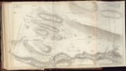
| Title: | Ault Fairn, with the Muir of Camault, Lunich-Keim | |
| Imprint: | Surveyed: 1800 | |
| Zoom Into Map: | Click on the map to view in greater detail. | |
| Field | Content | |
|---|---|---|
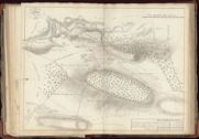
| Name: | Brown, George, 1747-1816 | |
| Title: | Plan of grounds in dispute between W.S. Dempster Esq. of Skibo and H. Houston Esq. of Creech by George Brown, 1815. | |
| Imprint: | 1815 | |
| Zoom Into Map: | Click on the map to view in greater detail. | |