Mapmakers
Your search for May, Peter returned 10 records.
Ordered chronologically (undated items first).
| Field | Content | |
|---|---|---|
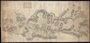
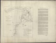
| Name: | May, Peter, approximately 1724-1795 | |
| Title: | Aberdeen - Coast between Dee and Don | |
| Imprint: | 1756 | |
| Zoom Into Map: | Click on the map to view in greater detail. | |
| Field | Content | |
|---|---|---|
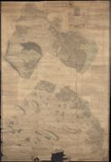
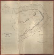
| Name: | May, Peter (ca. 1724/35 - 1795) | |
| Title: | A Survey of the Lands of Lovat in the Parish of Kirkhill part of His Majesty's annexed Estates in the County of Inverness North-Britain | |
| Imprint: | Surveyed: 1757 | |
| Zoom Into Map: | Click on the map to view in greater detail. | |
| Field | Content | |
|---|---|---|
| Name: | May, Peter (ca. 1724/35 - 1795) | |
| Title: | A Plan of Part of the Annexed Estate of Lovat lying in the Parish of Killtarlity and County of Inverness, from an accurate survey taken Anno 17--. | |
| Imprint: | Surveyed: 1757 | |
| Zoom Into Map: | Click on the map to view in greater detail. | |
| Field | Content | |
|---|---|---|
| Name: | May, Peter (ca. 1724/35 - 1795) | |
| Title: | A Plan of that Part of the Annexed Estate of Lovat lying in the Parish of Kilmorack and County of Inverness | |
| Imprint: | Surveyed: 1757 | |
| Zoom Into Map: | Click on the map to view in greater detail. | |
| Field | Content | |
|---|---|---|
| Name: | May, Peter (ca. 1724/35 - 1795) | |
| Title: | A Survey of the Barony of Glen Straferrer in the parish of Kiltarlity and Shire of Inverness part of his Majesty's annexed Estate of Lovat North-Britain | |
| Imprint: | Surveyed: 1758 | |
| Zoom Into Map: | Click on the map to view in greater detail. | |
| Field | Content | |
|---|---|---|
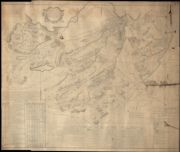
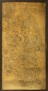
| Name: | May, Peter (ca. 1724/35 - 1795) | |
| Title: | …….Survey of Coygach ….. Parish ….part of his Majesty’s Annexed Estates ……… Cromarty North Britain. Surveyed by Pet May 1758 | |
| Imprint: | Surveyed: 1758 | |
| Zoom Into Map: | Click on the map to view in greater detail. | |
| Field | Content | |
|---|---|---|
| Name: | May, Peter (ca. 1724/35 - 1795) | |
| Title: | Plan of that Part of the Barony of Stratherrick called Dalcallick and Portclairs part of the Annexed Estate of Lovat made out from an accurate survey taken by ……Government Surveyors about 1760 | |
| Imprint: | Surveyed: 1760 | |
| Zoom Into Map: | Click on the map to view in greater detail. | |

| Field | Content | |
|---|---|---|
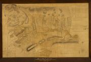
| Name: | May, Peter (ca. 1724/35 - 1795) | |
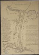
| Title: | A plan of the river Spey from the low water mark to Ballhagarty's Gavin, with the coast at high & low water / surveyed, October 1760, by Peter May surveyor. Engraved by Thos. Phinn. | |
| Imprint: | Edinburgh, 1761. | |
| Zoom Into Map: | Click on the map to view in greater detail. | |
| Field | Content | |
|---|---|---|
| Name: | May, Peter (ca. 1724/35 - 1795); Ainslie, John (1745-1828) | |
| Title: | A Plan of the Barony of Castle Leod belonging to the Right Hon Lady Elibank reduced to a small scale from an old plan of P May by John Ainslie Land Surveyor Edinburgh | |
| Imprint: | Original survey 1750s, copied 1796 | |
| Zoom Into Map: | Click on the map to view in greater detail. | |
| Field | Content | |
|---|---|---|
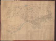
| Name: | May, Peter (ca. 1724/35 - 1795) | |
| Title: | A Survey of the River Findhorn with the fishing places, &c. / (W. Ballantine's lithog. Pet. May surveyor). | |
| Imprint: | [S.l., ca. 1830] | |
| Zoom Into Map: | Click on the map to view in greater detail. | |