Estate Maps, 1750s-1900s
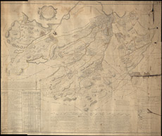

| Name: | May, Peter (ca. 1724/35 - 1795) |
| Title: | A Plan of Part of the Annexed Estate of Lovat lying in the Parish of Killtarlity and County of Inverness, from an accurate survey taken Anno 17--. |
| Imprint: | Surveyed: 1757 |
| Pagination: | 1 manuscript map: col.; 129 x 154 cm. |
| Shelfmark: | Lovat355 |
| Notes: | Scale 1:9695. ( 40 chains = 8.3 cm). Courtesy of Lovat Highland Estates and the North of Scotland Archaeological Society. View Lovat Highland Estates mapping. |
| Zoom Into Map: | Click on the map to view in greater detail. |