Estate Maps, 1750s-1900s
| Name: | May, Peter (ca. 1724/35 - 1795) |
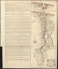
| Title: | A plan of the river Spey from the low water mark to Ballhagarty's Gavin, with the coast at high & low water / surveyed, October 1760, by Peter May surveyor. Engraved by Thos. Phinn. |
| Imprint: | Edinburgh, 1761. |
| Pagination: | 1 map ; 567 x 213 mm |
| Shelfmark: | EMS.s.291 |
| Zoom Into Map: | Click on the map to view in greater detail. |