Pont maps | Pont texts | biographies | history | subjects | further reading
Pont Maps of Scotland, ca. 1583-1614 - Manuscript Map List
View Pont maps without thumbnail images.
47 Pont maps.
Ordered by shelfmark.
| Field | Content | |
|---|---|---|
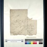
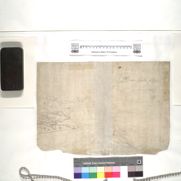
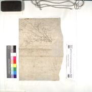
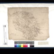
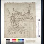
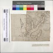
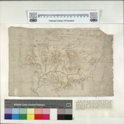
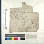
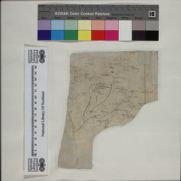
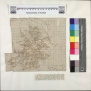
| Name: | Pont, Timothy, 1560?-1614? | |
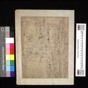
| Title: | [Durness and Tongue] - Pont 1 | |
| Shelfmark: | Adv.MS.70.2.9 (Pont 1) | |
| Imprint: | [ca. 1583-96] | |
| Zoom Into Map: | Click on the map to view in greater detail. | |
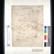
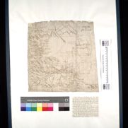
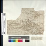
| Field | Content | |
|---|---|---|
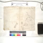
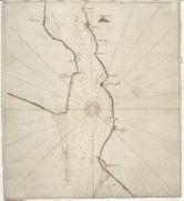
| Name: | Pont, Timothy, 1560?-1614? | |
| Title: | [Strathnaver; Kyle of Tongue] - Pont 2 (front) | |
| Shelfmark: | Adv.MS.70.2.9 (Pont 2) | |
| Imprint: | [ca. 1583-96] | |
| Zoom Into Map: | Click on the map to view in greater detail. | |
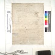
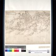
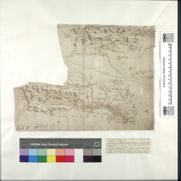
| Field | Content | |
|---|---|---|
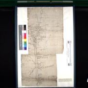
| Name: | Pont, Timothy, 1560?-1614? | |
| Title: | [Farr] - Pont 2 (back) | |
| Shelfmark: | Adv.MS.70.2.9 (Pont 2v) | |
| Imprint: | [ca. 1583-96] | |
| Zoom Into Map: | Click on the map to view in greater detail. | |
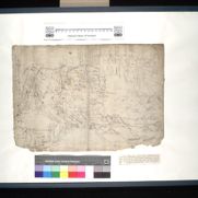
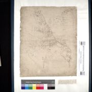
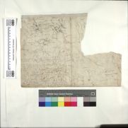
| Field | Content | |
|---|---|---|
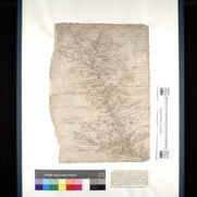
| Name: | Pont, Timothy, 1560?-1614? | |
| Title: | [Eddrachilles; Northwest Sutherland; Loch Shin] - Pont 3 (front) | |
| Shelfmark: | Adv.MS.70.2.9 (Pont 3) | |
| Imprint: | [ca. 1583-96] | |
| Zoom Into Map: | Click on the map to view in greater detail. | |
| Field | Content | |
|---|---|---|
| Name: | Pont, Timothy, 1560?-1614? | |
| Title: | [Ben Hee to Faraid head, Northwest Sutherland] - Pont 3 (back) | |
| Shelfmark: | Adv.MS.70.2.9 (Pont 3v) | |
| Imprint: | [ca. 1583-96] | |
| Zoom Into Map: | Click on the map to view in greater detail. | |

| Field | Content | |
|---|---|---|
| Name: | Pont, Timothy, 1560?-1614? | |
| Title: | [Wester Ross] - Pont 4 (front) | |
| Shelfmark: | Adv.MS.70.2.9 (Pont 4) | |
| Imprint: | [ca. 1583-96] | |
| Zoom Into Map: | Click on the map to view in greater detail. | |
| Field | Content | |
|---|---|---|
| Name: | Pont, Timothy, 1560?-1614? | |
| Title: | [Assynt] - Pont 4 (back) | |
| Shelfmark: | Adv.MS.70.2.9 (Pont 4v) | |
| Imprint: | [ca. 1583-96] | |
| Zoom Into Map: | Click on the map to view in greater detail. | |
| Field | Content | |
|---|---|---|
| Name: | Pont, Timothy, 1560?-1614? | |
| Title: | [The Great Glen and Glen Garry] - Pont 5 | |
| Shelfmark: | Adv.MS.70.2.9 (Pont 5) | |
| Imprint: | [ca. 1583-96] | |
| Zoom Into Map: | Click on the map to view in greater detail. | |
| Field | Content | |
|---|---|---|
| Name: | Pont, Timothy, 1560?-1614? | |
| Title: | [Strath Spey] - Pont 6 (front) | |
| Shelfmark: | Adv.MS.70.2.9 (Pont 6) | |
| Imprint: | [ca. 1583-96] | |
| Zoom Into Map: | Click on the map to view in greater detail. | |
| Field | Content | |
|---|---|---|
| Name: | Pont, Timothy, 1560?-1614? | |
| Title: | [River Nethy] - Pont 6 (back) | |
| Shelfmark: | Adv.MS.70.2.9 (Pont 6v) | |
| Imprint: | [ca. 1583-96] | |
| Zoom Into Map: | Click on the map to view in greater detail. | |
| Field | Content | |
|---|---|---|
| Name: | Pont, Timothy, 1560?-1614? | |
| Title: | [Ben Lawers; Glen Tanar; Strath Avon] - Pont 7 | |
| Shelfmark: | Adv.MS.70.2.9 (Pont 7) | |
| Imprint: | [ca. 1583-96] | |
| Zoom Into Map: | Click on the map to view in greater detail. | |
| Field | Content | |
|---|---|---|
| Name: | Pont, Timothy, 1560?-1614? | |
| Title: | [Moray and Nairn] - Pont 8 | |
| Shelfmark: | Adv.MS.70.2.9 (Pont 8) | |
| Imprint: | [ca. 1583-96] | |
| Zoom Into Map: | Click on the map to view in greater detail. | |
| Field | Content | |
|---|---|---|
| Name: | Pont, Timothy, 1560?-1614? | |
| Title: | [the coast of Banff] - Pont 9 | |
| Shelfmark: | Adv.MS.70.2.9 (Pont 9) | |
| Imprint: | [ca. 1583-96] | |
| Zoom Into Map: | Click on the map to view in greater detail. | |
| Field | Content | |
|---|---|---|
| Name: | Pont, Timothy, 1560?-1614? | |
| Title: | [Buchan] - Pont 10 | |
| Shelfmark: | Adv.MS.70.2.9 (Pont 10) | |
| Imprint: | [ca. 1583-96] | |
| Zoom Into Map: | Click on the map to view in greater detail. | |
| Field | Content | |
|---|---|---|
| Name: | Pont, Timothy, 1560?-1614? | |
| Title: | [Lower Deeside] - Pont 11 | |
| Shelfmark: | Adv.MS.70.2.9 (Pont 11) | |
| Imprint: | [ca. 1583-96] | |
| Zoom Into Map: | Click on the map to view in greater detail. | |
| Field | Content | |
|---|---|---|
| Name: | Pont, Timothy, 1560?-1614? | |
| Title: | [Loch Linnhe, Loch Eil and Loch Leven; Glen Lonan to Loch Etive; Muckairn; Strachur] - Pont 12 (front) | |
| Shelfmark: | Adv.MS.70.2.9 (Pont 12) | |
| Imprint: | [ca. 1583-96] | |
| Zoom Into Map: | Click on the map to view in greater detail. | |
| Field | Content | |
|---|---|---|
| Name: | Pont, Timothy, 1560?-1614? | |
| Title: | [Part of Glencoe] - Pont 12 (back) | |
| Shelfmark: | Adv.MS.70.2.9 (Pont 12v) | |
| Imprint: | [ca. 1583-96] | |
| Zoom Into Map: | Click on the map to view in greater detail. | |
| Field | Content | |
|---|---|---|
| Name: | Pont, Timothy, 1560?-1614? | |
| Title: | [Loch Eil and Loch Leven] - Pont 13 | |
| Shelfmark: | Adv.MS.70.2.9 (Pont 13) | |
| Imprint: | [ca. 1583-96] | |
| Zoom Into Map: | Click on the map to view in greater detail. | |
| Field | Content | |
|---|---|---|
| Name: | Pont, Timothy, 1560?-1614? | |
| Title: | [Mid-Argyll; from Dunoon to Inverary and Loch Awe] - Pont 14 | |
| Shelfmark: | Adv.MS.70.2.9 (Pont 14) | |
| Imprint: | [ca. 1583-96] | |
| Zoom Into Map: | Click on the map to view in greater detail. | |
| Field | Content | |
|---|---|---|
| Name: | Pont, Timothy, 1560?-1614? | |
| Title: | [Argyll, north of the Crinan Canal] - Pont 15 (front) | |
| Shelfmark: | Adv.MS.70.2.9 (Pont 15) | |
| Imprint: | [ca. 1583-96] | |
| Zoom Into Map: | Click on the map to view in greater detail. | |
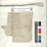
| Field | Content | |
|---|---|---|
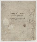
| Name: | Pont, Timothy, 1560?-1614? | |
| Title: | [Argyll title and text ] - Pont 15 (back) | |
| Shelfmark: | Adv.MS.70.2.9 (Pont 15v) | |
| Imprint: | [ca. 1583-96] | |
| Zoom Into Map: | Click on the map to view in greater detail. | |
| Field | Content | |
|---|---|---|
| Name: | Pont, Timothy, 1560?-1614? | |
| Title: | [Gare Loch, Loch Long and Holy Loch] - Pont 16 | |
| Shelfmark: | Adv.MS.70.2.9 (Pont 16) | |
| Imprint: | [ca. 1583-96] | |
| Zoom Into Map: | Click on the map to view in greater detail. | |
| Field | Content | |
|---|---|---|
| Name: | Pont, Timothy, 1560?-1614? | |
| Title: | [Loch Lomond] - Pont 17 | |
| Shelfmark: | Adv.MS.70.2.9 (Pont 17) | |
| Imprint: | [ca. 1583-96] | |
| Zoom Into Map: | Click on the map to view in greater detail. | |
| Field | Content | |
|---|---|---|
| Name: | Pont, Timothy, 1560?-1614? | |
| Title: | [Loch Tay: the head of Glen Tanar] - Pont 18 | |
| Shelfmark: | Adv.MS.70.2.9 (Pont 18) | |
| Imprint: | [ca. 1583-96] | |
| Zoom Into Map: | Click on the map to view in greater detail. | |
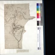
| Field | Content | |
|---|---|---|
| Name: | Pont, Timothy, 1560?-1614? | |
| Title: | [Forest of Atholl] - Pont 19 | |
| Shelfmark: | Adv.MS.70.2.9 (Pont 19) | |
| Imprint: | [ca. 1583-96] | |
| Zoom Into Map: | Click on the map to view in greater detail. | |
| Field | Content | |
|---|---|---|
| Name: | Pont, Timothy, 1560?-1614? | |
| Title: | [Glen Tilt] - Pont 20 | |
| Shelfmark: | Adv.MS.70.2.9 (Pont 20) | |
| Imprint: | [ca. 1583-96] | |
| Zoom Into Map: | Click on the map to view in greater detail. | |
| Field | Content | |
|---|---|---|
| Name: | Pont, Timothy, 1560?-1614? | |
| Title: | [Lower Glen Almond; Strathearn] - Pont 21 | |
| Shelfmark: | Adv.MS.70.2.9 (Pont 21) | |
| Imprint: | [ca. 1583-96] | |
| Zoom Into Map: | Click on the map to view in greater detail. | |
| Field | Content | |
|---|---|---|
| Name: | Pont, Timothy, 1560?-1614? | |
| Title: | [South Strathearn; Glen Almond ] - Pont 22 (front) | |
| Shelfmark: | Adv.MS.70.2.9 (Pont 22) | |
| Imprint: | [ca. 1583-96] | |
| Zoom Into Map: | Click on the map to view in greater detail. | |
| Field | Content | |
|---|---|---|
| Name: | Pont, Timothy, 1560?-1614? | |
| Title: | [Lochaber] - Pont 22 (back) | |
| Shelfmark: | Adv.MS.70.2.9 (Pont 22v) | |
| Imprint: | [ca. 1583-96] | |
| Zoom Into Map: | Click on the map to view in greater detail. | |
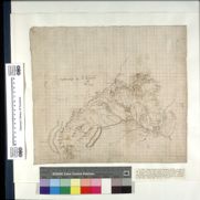
| Field | Content | |
|---|---|---|
| Name: | Pont, Timothy, 1560?-1614? | |
| Title: | [Garry, Tummel, and Upper Tay; Dunkeld to Blairgowrie ] - Pont 23 (front) | |
| Shelfmark: | Adv.MS.70.2.9 (Pont 23) | |
| Imprint: | [ca. 1583-96] | |
| Zoom Into Map: | Click on the map to view in greater detail. | |
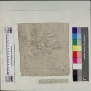
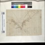
| Field | Content | |
|---|---|---|
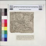
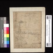
| Name: | Pont, Timothy, 1560?-1614? | |
| Title: | [Poem ] - Pont 23 (back) | |
| Shelfmark: | Adv.MS.70.2.9 (Pont 23v) | |
| Imprint: | [ca. 1583-96] | |
| Zoom Into Map: | Click on the map to view in greater detail. | |
| Field | Content | |
|---|---|---|
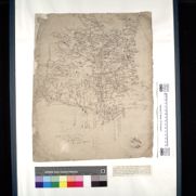
| Name: | Pont, Timothy, 1560?-1614? | |
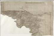
| Title: | [Auchtergaven and Kinclaven, Perthshire] - Pont 24 | |
| Shelfmark: | Adv.MS.70.2.9 (Pont 24) | |
| Imprint: | [ca. 1583-96] | |
| Zoom Into Map: | Click on the map to view in greater detail. | |
| Field | Content | |
|---|---|---|
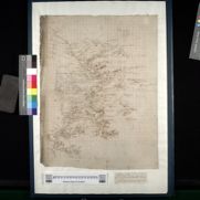
| Name: | Pont, Timothy, 1560?-1614? | |
| Title: | [Lower Strath Tay from Dunkeld to Benchil] - Pont 25 (front) | |
| Shelfmark: | Adv.MS.70.2.9 (Pont 25) | |
| Imprint: | [ca. 1583-96] | |
| Zoom Into Map: | Click on the map to view in greater detail. | |
| Field | Content | |
|---|---|---|
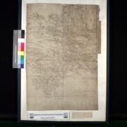
| Name: | Pont, Timothy, 1560?-1614? | |
| Title: | [Upper Perthshire] - Pont 25 (back) | |
| Shelfmark: | Adv.MS.70.2.9 (Pont 25v) | |
| Imprint: | [ca. 1583-96] | |
| Zoom Into Map: | Click on the map to view in greater detail. | |
| Field | Content | |
|---|---|---|
| Name: | Pont, Timothy, 1560?-1614? | |
| Title: | [Lower Angus and Perthshire east of the Tay] - Pont 26 | |
| Shelfmark: | Adv.MS.70.2.9 (Pont 26) | |
| Imprint: | [ca. 1583-96] | |
| Zoom Into Map: | Click on the map to view in greater detail. | |
| Field | Content | |
|---|---|---|
| Name: | Pont, Timothy, 1560?-1614? | |
| Title: | [Strathardle; Glenshee and Glenericht] - Pont 27 | |
| Shelfmark: | Adv.MS.70.2.9 (Pont 27) | |
| Imprint: | [ca. 1583-96] | |
| Zoom Into Map: | Click on the map to view in greater detail. | |
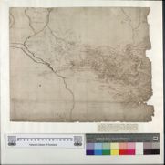
| Field | Content | |
|---|---|---|
| Name: | Pont, Timothy, 1560?-1614? | |
| Title: | [Glen Isla and Lintrathen; parts of Strathmore near Coupar Angus] - Pont 28 | |
| Shelfmark: | Adv.MS.70.2.9 (Pont 28) | |
| Imprint: | [ca. 1583-96] | |
| Zoom Into Map: | Click on the map to view in greater detail. | |
| Field | Content | |
|---|---|---|
| Name: | Pont, Timothy, 1560?-1614? | |
| Title: | [Middle Strathmore] - Pont 29 | |
| Shelfmark: | Adv.MS.70.2.9 (Pont 29) | |
| Imprint: | [ca. 1583-96] | |
| Zoom Into Map: | Click on the map to view in greater detail. | |
| Field | Content | |
|---|---|---|
| Name: | Pont, Timothy, 1560?-1614? | |
| Title: | [North Esk; South Esk] - Pont 30 | |
| Shelfmark: | Adv.MS.70.2.9 (Pont 30) | |
| Imprint: | [ca. 1583-96] | |
| Zoom Into Map: | Click on the map to view in greater detail. | |
| Field | Content | |
|---|---|---|
| Name: | Pont, Timothy, 1560?-1614? | |
| Title: | [West Water and Noran Water ] - Pont 30 (back) | |
| Shelfmark: | Adv.MS.70.2.9 (Pont 30v) | |
| Imprint: | [ca. 1583-96] | |
| Zoom Into Map: | Click on the map to view in greater detail. | |
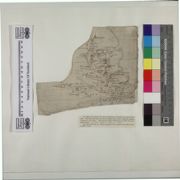
| Field | Content | |
|---|---|---|
| Name: | Pont, Timothy, 1560?-1614? | |
| Title: | [The East Central Lowlands (Stirling, Falkirk & Kilsyth)] - Pont 32 | |
| Shelfmark: | Adv.MS.70.2.9 (Pont 32) | |
| Imprint: | [ca. 1583-96] | |
| Zoom Into Map: | Click on the map to view in greater detail. | |
| Field | Content | |
|---|---|---|
| Name: | Pont, Timothy, 1560?-1614? | |
| Title: | [Renfrewshire] - Pont 33 | |
| Shelfmark: | Adv.MS.70.2.9 (Pont 33) | |
| Imprint: | [ca. 1583-96] | |
| Zoom Into Map: | Click on the map to view in greater detail. | |
| Field | Content | |
|---|---|---|
| Name: | Pont, Timothy, 1560?-1614? | |
| Title: | [Glasgow and the county of Lanark] - Pont 34 | |
| Shelfmark: | Adv.MS.70.2.9 (Pont 34) | |
| Imprint: | [ca. 1583-96] | |
| Zoom Into Map: | Click on the map to view in greater detail. | |
| Field | Content | |
|---|---|---|
| Name: | Pont, Timothy, 1560?-1614? | |
| Title: | [Nithsdale; part of Teviotdale] - Pont 35 | |
| Shelfmark: | Adv.MS.70.2.9 (Pont 35) | |
| Imprint: | [ca. 1583-96] | |
| Zoom Into Map: | Click on the map to view in greater detail. | |
| Field | Content | |
|---|---|---|
| Name: | Pont, Timothy, 1560?-1614? | |
| Title: | [South Uist; Inverkeithing] - Pont 36 (front) | |
| Shelfmark: | Adv.MS.70.2.9 (Pont [36]) | |
| Imprint: | [ca. 1583-96] | |
| Zoom Into Map: | Click on the map to view in greater detail. | |
| Field | Content | |
|---|---|---|
| Name: | Pont, Timothy, 1560?-1614? | |
| Title: | [West Lothian and Linlithgow] - Pont 36 (back) | |
| Shelfmark: | Adv.MS.70.2.9 (Pont [36]v) | |
| Imprint: | [ca. 1583-96] | |
| Zoom Into Map: | Click on the map to view in greater detail. | |
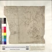
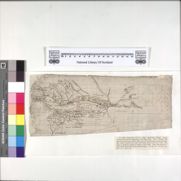
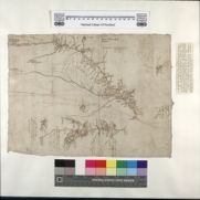
| Field | Content | |
|---|---|---|
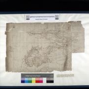
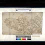
| Name: | Marr, John, fl. 1660-1720? | |
| Title: | [A chart of the mouth of the Firth of Tay]. | |
| Shelfmark: | Adv.MS.70.2.9 (Pont 31) | |
| Imprint: | [ca. 1666] | |
| Zoom Into Map: | Click on the map to view in greater detail. | |