Maps of Scotland
| Field | Content |
|---|---|
| Name: | Pont, Timothy, 1560?-1614? |
| Title: | [Loch Lomond] - Pont 17 |
| Imprint: | [ca. 1583-96] |
| Pagination: | 1 manuscript map ; 41 x 28 cm. |
| Shelfmark: | Adv.MS.70.2.9 (Pont 17) |
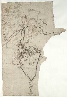
| Notes: | The whole of Loch Lomond is shown. Although much of the surrounding land in the south is not mapped, this sheet does extend in the east as far as Loch Aird (Loch Ard) and the headwaters of the River Forth. Just to the north (top right), the western end of Loch Ketterin (Loch Katrine) is drawn. The most northerly point depicted is Bin Luy (Ben Lui), a 3708ft mountain. On the western margin is Loch Fyn (Loch Fynne), and just to the south is Loch Goil. At the very southernmost end, on the bottom margin, we find the town of Dun Britton (Dumbarton) on the Firth of Clyde.
the loch The Clan Farlan
View the Pont Maps website. View maps by Blaeu and Robert and James Gordon. |
| Zoom Into Map: | Click on the map to view in greater detail. |