Maps of Scotland
| Field | Content |
|---|---|
| Name: | Pont, Timothy, 1560?-1614? |
| Title: | [Glen Isla and Lintrathen; parts of Strathmore near Coupar Angus] - Pont 28 |
| Imprint: | [ca. 1583-96] |
| Pagination: | 1 manuscript map ; 41 x 30 cm. |
| Shelfmark: | Adv.MS.70.2.9 (Pont 28) |
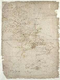
| Notes: | This map shows three separate maps of adjacent country in Glen Isla, Lintrathen, and parts of Strathmore near Coupar Angus. Pont 28(1), the main map covering most of the sheet is of Glen Isla from its headwaters at Caenlochan down to Alyth, and including the tributaries of Glen Isla to the east between Lintrathen and Glen Damff. Pont 28(2-5) below focus on a small area of Strathmore further south, adjacent to the confluences of the Alyth Burn, the Melgam Water, the Dean Water and the River Ericht with the River Isla. Pont 28(6) is an even smaller detail of the area immediately adjacent to the confluence of the Alyth Burn and the River Isla. Pont 28(1) Glen Isla and Lintrathen
Heir ar Pont 28(2)-(6) Parts of Strathmore near Coupar Angus
View the Pont Maps website. View maps by Blaeu and Robert and James Gordon. |
| Zoom Into Map: | Click on the map to view in greater detail. |