Maps of Scotland
Name: | Pont, Timothy, 1560?-1614? |
Title: | [Ben Lawers; Glen Tanar; Strath Avon] - Pont 7 |
Imprint: | [ca. 1583-96] |
Pagination: | 1 manuscript map ; 17 x 30 cm. |
Shelfmark: | Adv.MS.70.2.9 (Pont 7) |
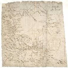
Notes: | This sheet contains four separate units: Pont 7(1), a profile of Ben Lawers, the 3984 ft mountain just north of Loch Tay, Perthshire; Pont 7(2), a small neat map showing the catchment area of the Water of Tanar from near its confluence with the River Dee to the high hills around its source; Pont 7(3), a map showing the River Avon (and its tributaries) from its confluence with the River Spey in the north to Ben Avon and Loch Builg in the south; and Pont 7(4), a map of lower Strath Avon.Much of Pont's original, but now faded, mapping in brown ink was later over-drawn in a darker ink, probably by Robert Gordon. Pont 7(1) Ben Lawers - The Ben Lawers profile shows the mountain from the south.
- The Ben Lawers profile may occur on this sheet because it was once attached to Pont 18, which covers Loch Tay and Ben Lawers; compare this profile with the one that appears on Pont 18(1).
Pont 7(2) Glen Tanar, Aberdeenshire - Compare this drawing with that on Pont 18(2).
- It was probably Robert Gordon who depicted the woodland of the lower slopes with characteristic neat tree symbols.
Pont 7(3) Strath Avon and Glen Livet- There are several notes on this map, some of which have been made more legible by Robert Gordon's over-writing. Above Byn Bynick (Bynack More, 3574ft), are two notes:
- Soulichin Bin Avin a great wildernes rich in Deer
and - The loch of Avin far furthir
out [th]en [th]is be 5 mylles Above Glen-Builg is written: - this branch to reach
4 myles more to th[e] springs Other similar notes are transcribed by Stone (1989).
Pont 7(4) Lower Strath Avon- Many of the names on this small map have been written on the wrong side of the river. It is therefore a 'mirror image'. Robert Gordon may have recognised this fault, as his note by the map reads:
- The laich of Strath-Avin it is evil and wrong
For all maps on this sheet:
- See also Pont 6 (front), which includes the north western part of 7(3) and the whole of 7(4). For additional coverage of 7(1) and 7(2) see Pont 18(1 and 2 respectively).
- The following manuscript maps by Robert Gordon cover at least part of Pont 7(3 and 4): 2, 3, 4, 24, 25, and 26.
- The most relevant printed maps by Joan Blaeu which include the area of Pont 7(3 and 4) are his Braid-Allaban and Aberdonia & Banfia.
View the Pont Maps website. View maps by Blaeu and Robert and James Gordon. |
Zoom Into Map: | Click on the map to view in greater detail. |
Copyright Enquiries & Copies Help