Maps of Scotland
| Field | Content |
|---|---|
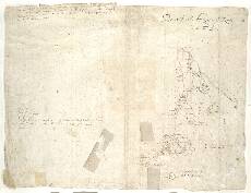
| Name: | Pont, Timothy, 1560?-1614? |
| Title: | [Assynt] - Pont 4 (back) |
| Imprint: | [ca. 1583-96] |
| Pagination: | 1 manuscript map ; 41 x 31 cm. |
| Shelfmark: | Adv.MS.70.2.9 (Pont 4v) |
| Notes: | This small map features on the back of the manuscript called Pont 4, and is known as Pont 4(7) because six other maps feature on the other side of the sheet. It shows an area east of modern Lochinver, including L: Assynn (Loch Assynt) and the 3273ft mountain Bin moir Assynn (Ben More Assynt).
View the Pont Maps website. View the Pont Maps website. View maps by Blaeu and Robert and James Gordon. |
| Zoom Into Map: | Click on the map to view in greater detail. |