Maps of Scotland
| Field | Content |
|---|---|
| Name: | Pont, Timothy, 1560?-1614? |
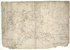
| Title: | [Eddrachilles; Northwest Sutherland; Loch Shin] - Pont 3 (front) |
| Imprint: | [ca. 1583-96] |
| Pagination: | 1 manuscript map ; 41 x 28 cm. |
| Shelfmark: | Adv.MS.70.2.9 (Pont 3) |
| Notes: | This is the front of the manuscript called Pont 3. Two maps, known as Pont 3(1) and Pont 3(2), are on this side of the sheet. A third map, Pont 3(3) is on the back of it. Pont 3(1) shows the north-west coast of Scotland from Eddrachillis Bay in the south to Strath Shinary in the north. It includes an area as far inland as the west end of Loch Shin and the 2,393 foot high hill Sàbhal Beag. Pont 3(2) is a very small map easily separated from map Pont 3(1) because it is drawn at 90 degrees to it. The map shows the whole of Loch Syin (Loch Shin), which lies north west from the modern town of Lairg. Ben More Assynt, a 3273ft high mountain, is depicted in the top left corner. Pont 3(1)
View the Pont Maps website. View maps by Blaeu and Robert and James Gordon. |
| Zoom Into Map: | Click on the map to view in greater detail. |