How to find all georeferenced layer URLs
- To access any of our georeferenced maps and their associated XYZ or WMTS URLs (for adding the layer into QGIS, ArcGIS, geojson.io or OpenStreetMap - see Guides), go to our Georeferenced Maps viewer to browse our maps and select the dark blue Overlay tab in the footer for your chosen map (see image).
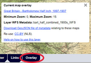
- Once you select this dark blue Overlay tab, the Current map overlay link in the popup box will take you to a home page appearing as shown in the image (or see, for example, the Bartholomew half-inch 1940s layer). Many of our georeferenced layers have home pages in this style, with links to the WMTS and XYZ URLs to the upper right.
For using XYZ layers, note down too the Maximum Zoom Level. - The Layer WFS Metadata is the name of the TypeName or Layer in our Web Feature Service, allowing you to see the geographic metadata relating to the specific map within the georeferenced layer. Further details are available on how to use this in QGIS and ArcGIS.
- You can Download a GeoJSON file of metadata relating to the georeferenced layer. You can view GeoJSON files in QGIS, in geojson.io, or use the Add Layer tool to view them in our Georeferenced Maps viewer. This GeoJSON file can also be used in MapReader.
- Please comply with the specific Re-use terms, as stated for each layer. NLS has default CC-BY re-use terms, but there are layers which have other re-use terms (further information).
- You can then follow the Guides below, to paste these URLs and re-use the layers in QGIS, ArcGIS, geojson.io, or OpenStreetMap.

View Guides:
- Using georeferenced layers in QGIS - as XYZ / WMTS tilesets
- Using georeferenced layers in ArcGIS – as XYZ / WMTS tilesets
- Using georeferenced layers inside geojson.io
- Using georeferenced layers inside OpenStreetMap
See also:
- Brief georeferenced layers list - with XYZ / WMTS URLs
View our main Re-using georeferenced maps guides.