Projects
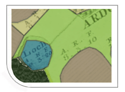
Alexander Innes - Jamaica Journal (1823-24)
- This map viewer allows you to journey through space, time and text in early 19th century Jamaica.
- Combines the Journal of Alexander Innes (1823-24) with James Robertson's mapping of Jamaica (1804), showing the locations that Innes visited highlighted in blue.
- Read further information about Alexander Innes, about the journal and map sources, and about the resource. You can also download the data.

ANZMapS - map viewers for putting Historical Maps Online
A set of viewers which can be used for putting Historical Maps Online.
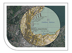
- These viewers were put together for a half-day workshop as part of the GeoCart'2018 conference in Wellington, New Zealand, 5-7 September 2018. The workshop was kindly supported by the Australian and New Zealand Map Society.
- The workshop focused on using open-source tools, particularly OpenLayers and GeoServer, to build a set of basic map viewers.
- The viewers included those focusing on search and retrieval of maps (using clickable indexes, bounding boxes, and marker pins), and those focused on displaying georeferenced maps (with transparency sliders, split-screen viewers, spy viewers, and 3D viewers.
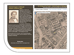
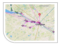
Frederick Douglass in Edinburgh and Scotland - map viewers
- These map viewers form part of the Our Bondage and Our Freedom project, celebrating the 200 year anniversary of the birth of African American activist and author, Frederick Douglass, in 2018.
- They include a map of the places in Edinburgh where Frederick Douglass lived, held meetings and gave speeches during his antislavery campaign.
- There are also map viewers showing Black Abolitionists in Edinburgh, and of Frederick Douglass in Scotland.
Family Portrait: the Scots-Italians 1890-1940
A map showing where Italians lived or worked in Scotland during the 1930s.
- This map has been created to accompany the free exhibition Family Portrait: The Scots Italians 1890 – 1940 at National Records of Scotland, Edinburgh, 3 December 2015 - 29 January 2016.
- The names and addresses are primarily based on the Scottish entries in the 1936 edition of the Guida Generale Degli Italiani in Gran Bretagna (General Guide to Italians in Great Britain, published in London).
GB1900 place name project
The GB1900 Project created a detailed list of the 2.5 million place names on Ordnance Survey six-inch to the mile maps of Britain (1888-1913). The project ran between September 2016 and December 2017, successfully collecting 2.5 million names by volunteers.
The GB1900 dataset can be searched in our Georeferenced Maps viewer using the Search OS six-inch 1888-1913 names: box - read our Recent Additions for further details. The GB1900 dot distribution maps allow the initial results of the GB1900 transcriptions to be viewed. You can zoom in on any place name, click on it, and read the name. There are also demonstration distributions of features and names - for example, for quarries and collieries, 'Footpath' names, and Public Buildings. The dataset is freely available from the Vision of Britain data download page.
GREMLIN Map Viewers
GREMLIN is investigating land use over the last 200 years for the Earlstoun and Holm Estates in the parishes of Balmaclellan, Dalry, and Kells in the Glenkens, Galloway.
GREMLIN is the Glenkens Rectified Estate Mapping and Land use Information Network. The project began in March 2023, with three main initial aims:
- to georeference and seam together 44 estate maps relating to the Earlstoun and Holm Estates
- to trace the land use from these estate maps, recording the land use parcels as shown on the maps
- to present these layers of estate mapping and land use information in online viewers
Read help about the viewers and further information on land use.
This is a collaborative project between the Dumfries Archival Mapping Project, the Galloway Glens Landscape Partnership, and the National Library of Scotland.
Historic Maps API layers
A set of detailed historic map layers for use in other websites
These seamless historic mapping API layers provide:
- detailed historic map coverage of Great Britain and London
- very fast and reliable hosting
- attractive and useful backdrops for your own markers or geographic data
- quick and easy ability to incorporate inside your own web applications
- quick and easy ability to add into desktop GIS software
- conformance with international web-mapping standards
New (July 2024) Historic parks in England, 1890s-1900s
Explore historic parks in England between the 1890s and 1900s.
- This collaborative project between Zulu Ecosystems and the Forestry Commission (FC) involved extracting a layer of parkland from Ordnance Survey six-inch 2nd edition maps, using a combination of machine learning, post-processing techniques and manual verification.
- This digital resource is designed to support efforts in tree planning and landscape conservation, ensuring both accessibility and integrity of the landscape.
- Corrections are invited on the layer to help improve accuracy (View examples). The dataset layer will be updated regularly, and new versions released, to ensure the highest possible accuracy of the layer.
- A collaborative project with the Forestry Commission (FC) and Zulu Ecosystems, who have extracted the layer (Further information).
Irrigation Tanks in Southern India
The Irrigation Tanks in Southern India viewer is part of a PhD project studying water histories and digital mapping in the Kaveri river catchment
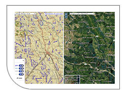
- the map highlights irrigation tank features traced from early 20th century Survey of India maps
- a wetness estimate for tanks can be viewed - read further information.
- a related Coimbatore viewer allows fieldwork data including interview transcriptions and photographs to be viewed
- historic methods of water management, including irrigation tanks, could offer partial solutions to present-day water scarcity problems
Lesmahagow Place Names Database
A map-based interface to a detailed gazetteer of place names in the old parish of Lesmagahow
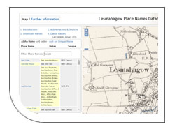
- 4,000 records which relate to over 600 place names in the old parish of Lesmagahow
- view the place names in different orders and search/filter on a text string
- click on the name to position the map at that location, and select a set of georeferenced maps, from the 12th to the 21st century, for viewing the name geographically
- useful for family history researchers, local historians, linguistic place name researchers and anyone with an interest in the area
MapReader - Railspace and Buildings Datasets Viewer
A viewer for the MapReader railway infrastructure and buildings point datasets
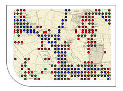
- Allows selected outputs from the MapReader tool, produced by the Living with Machines project.
- MapReader is an end-to-end computer vision (CV) pipeline for exploring and analyzing images at scale, which is especially well suited to series maps such as the Ordnance Survey collections held by the National Library of Scotland (Read further information).
- This MapReader project used the National Library of Scotland's Ordnance Survey Six-inch to the Mile, 1888-1914 maps of England, Scotland, and Wales, to look for railway infrastructure and buildings.
- Allows 1,762,152 point records relating to buildings, and 487,360 point records relating to railway infrastructure to be viewed. Zoom in and click on a point record on the map to view detailed information.
Thomas Pennant map tours viewer
A viewer showing the itineraries of Thomas Pennant and his Tours to Scotland, 1769 and 1772
- Shows the three tours of Thomas Pennant to Scotland in 1769 and 1772, as well as Johnson and Boswell's tour of 1773, as a set of clickable locations, giving the dates visited for each place, the form of the name used, and the page in the relevant original tour volumes.
- The split-screen viewer allows the routes to be viewed on modern day maps, as well as compared to relevant historical maps from the 18th and 19th centuries.
- A collaborative map application with the Curious Travellers Project based at the University of Glasgow and University of Wales, Aberystwyth.
Place and Poetry in Premodern Scotland (Due for completion: August 2024)
View maps exploring the locations of places within several early-modern Scottish poems
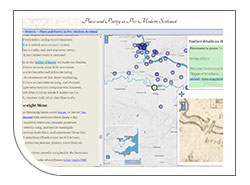
- This project is examining of the cultural representation of place in premodern Scottish poetry (medieval and early modern periods, c. 1400-1700).
- It foregrounds place as critical for understanding how premodern Scots experienced their lived and imagined environments.
- It is dedicated to how places were presented, imagined, and described, in the poetry of premodern Scotland.
- A collaborative project with University of Bristol, funded by the British Academy.
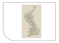
Scotland - Land Use viewer
A split-screen map viewer for comparing 1930s land use with 2015 land use
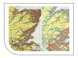
- compare the 1930s Land Utilisation Survey maps for Scotland with the 2015 Historic land use Assessment (HLA Map) layer
- view the significant changes in the Scottish landscape in the 20th century, including afforestation, urbanisation, new reservoirs, and changes to pasture and arable land
- a collaboratiive project with Historic Environment Scotland
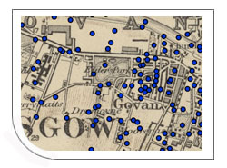
Scottish water mills website
A viewer for showing the locations and details of over 9,000 mills in Scotland in the 19th century
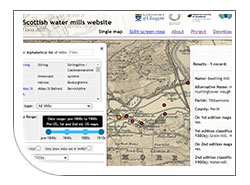
- combines records from the GB1900 Gazetteer and Canmore, as well as first-hand research based on Ordnance Survey first and second edition mapping.
- provides options to query and filter the mill records by name, mill type, date, and related features.
- ability to compare distributions of mills side-by-side in a split-screen viewer.
- read supporting information about mills in Scotland, the project workflow, and how to download the mills data.
The Stevenson Maps and Plans of Scotland, 1660 - 1940
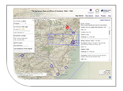
- A web resource for exploring over 2,000 records of plans relating to historical engineering in Scotland from the Stevenson archive.
- Records for Stevenson plans of Scottish places can be viewed, sorted and filtered using a dynamic map interface.
- Browse a full list of the places, subjects and people featured in the plans, or search them by keyword.
- Read supporting information about the Stevensons, their maps and plans, further resources, and about this project.
Stornoway and environs historic maps, 1780s-1960s / Mapaichean eachdraidheil Steòrnabhagh agus mun cuairt, 1780s-1960s
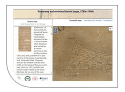
- This website is a collaborative project between Western Isles Libraries and the National Library of Scotland. This has seen the conservation and digitisation of historic maps to allow their wider availability online
- Explore a selection of historic maps of Stornoway and environs, dating between 1785-1964, read about them, and view them as georeferenced overlays
- The maps provide many insights into the development of Stornoway over the last two centuries, including proposals (some not implemented) for its development
Visualising Urban Geographies
A project that provides mapping tools for historians.
Visualising Urban Geographies combines geo-referenced maps with historical information:
- new geo-referenced historical maps and boundaries of Edinburgh (1765-1950)
- guides for georeferencing maps, features and putting maps online
Woodland in Scotland, 1840s-1880s
Explore woodland in Scotland between the 1840s and 1880s.

- This project has extracted a woodland layer from Ordnance Survey six-inch 1st edition maps, using machine learning, post-processing techniques and manual verification. The depiction of woodland on these maps is one of the most comprehensive records of ancient woodland in Scotland.
- Corrections are invited on the layer to help improve accuracy (View examples). The dataset layer will be updated regularly, and new versions released, to ensure the highest possible accuracy of the layer.
- A collaborative project with Zulu Ecosystems, who have extracted the layer (Further information).