Lockharts of Lee Estate mapping, 1770s-1950s
The maps below form part of the Maps and plans from the papers of the family Lockhart of Lee and Carnwath. As many of the maps are fragile, or are large rolled maps, only the maps listed below have so far been scanned (December 2020).
The wider Papers of the family of Lockhart of Lee and Carnwath were presented to the Library between 1967 and 1978, by S F Macdonald Lockhart of Lee and Carnwath. The Lockharts held the barony of Lee in Lanarkshire from the 14th century at least, but apart from a few charters this collection dates from the 17th to the early 20th century. The direct line of lairds of Lee, from Sir James, Lord Justice Clerk, and Sir William, Cromwell's ambassador, died out in 1777. Lee then came into the possession of the descendants of Sir James's younger son, Sir George Lockhart, Lord President, who had acquired large holdings of land consolidated into the baronies of Carnwath and Dryden: firstly General James Lockhart, Count of the Holy Roman Empire, whose son died without issue in 1802, and secondly Sir Alexander Macdonald Lockhart, 1st Baronet. With the death without issue of Sir Simon, 5th Baronet, in 1919, the estates passed to a cousin, S F Macdonald Lockhart.
Our Manuscripts Department hold the main corpus of written material relating to Lockharts of Lee Estates. These provide fuller information and essential context to understanding the maps available on this website.
The Lockharts of Lee Estate maps can be searched for on these pages:
- Estate Maps of Scotland, 1730s-1950s - Lanarkshire
- View the estate maps with a graphic index
- Mapmakers and surveyors
View the maps in shelfmark order:
| Shelfmark | Title | Date |
| MS.27639 | Plan of part of the barony of Carnwath, including Libberton and Millridge: 1771. | 1771 |
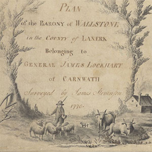
| MS.27641 | Plan of the barony of Walston (Walstone): 1770. | 1770 |
| MS.27643 | (not yet scanned) - Plan of Strawfrank (Strathfrank): 1809. | 1797 |
| MS.27644 | Plan of the estate of Newholm: 1819. | 1819 |
| MS.27645 | (not yet scanned) - Plan of the lands of Newbigging: 1821. | 1797 |
| MS.27647 | Plan and section of part of the River South Medwin, between Walstonmill and Newholm, and the adjoining bogs under drainage, showing the proposed cut and principal drains: 1829. | 1829 |
| MS.27649 | (not yet scanned) - Plan of Corbiehall Farm: 1809. | 1797 |
| MS.27650 | Plan of the lands of Westhall and Hills of Dunsyre: 1848. | 1848 |
| MS.27651 | (not yet scanned) - Plan (2 copies) of the lands of Dryden: 1837. | 1828 |
| MS.27652 | (not yet scanned) - Plan of the lands and barony of Covington: 1849. | 1828 |
| MS.27653 | (not yet scanned) - Plan of part of the boundaries of Calla (Caldlaw) Farm, showing where the boundaries disagree with those shown on James Stevenson's plan of part of the barony of Carnwath in 1770: 1852. | 1828 |
| MS.27654 | (not yet scanned) - Plan of the farms of Moat and Ploverhall: 1847, based on plan of 1831. | 1831, 1847 |
| MS.27655 | Plan of Headsmuir limestone workings: 1847. | 1847 |
| MS.27656 | Plan of Headsmuir lime works: 1851. | 1851 |
| MS.27657 | Plan of Headsmuir open cast ironstone working: 1851. | 1851 |
| MS.27658 | Plan of the farm of Westside of Nemphlar: 1860. | 1860 |
| MS.27659 | Plan of Wester Walston: 1859. | 1859 |
| MS.27660 | (not yet scanned) - Plan of South Tarbrax: 1859. | 1859 |
| MS.27661 | (not yet scanned) - Plan of Walston Mansion: 1859. | 1859 |
| MS.27662 | (not yet scanned) - Plan of Shodshill Farm: 1859. | 1859 |
| MS.27663 | (not yet scanned) - Plan of Hillhead: 1859. | 1859 |
| MS.27664 | Plan of Covington Mill: 1859. | 1859 |
| MS.27665 | (not yet scanned) - Plan of Covington Mains: 1859. | 1859 |
| MS.27666 | (not yet scanned) - Plan of Dykefoot: 1859. | 1859 |
| MS.27667 | (not yet scanned) - Plan of the farm of Newbigging Mill: 1818. | 1797 |
| MS.27668 | Plan of the lands of Park and Burnhouse: 1835. | 1835 |
| MS.27669 | Plan of the River South Medwin from Garvald House to Newholm Bridge: 1859. | 1859 |
| MS.27672 | (not yet scanned) - Plan of Headsmuir mineral workings: 1847. | 1828 |
| MS.27673 | Plan of the Fulwood lime work: 1851, corrected to 1854. | 1851, 1854 |
| MS.27676 | Plan showing proposed march fence and excambion between the farms of Greens and Weston: 1853. | 1853 |
| MS.27677 | (not yet scanned) - Plan of roads at Ladywell, showing the course of the stream from the well: 1863. | 1859 |
| MS.27678 | Plan of Butterhole, Headsmuir and part of Burnhead, in the estate of Lee: [ca.1860]. | [ca.1860] |
| MS.27679 | (not yet scanned) - Plan of part of the River Clyde at Hillhead and section of proposed embankment: 1851. | 1828 |
| MS.27680 | Plan of plantation on Carnwath Estate, destroyed by fire; [late 19th century]. | [late 19th century] |
| MS.27681 | Plan of Mr George Bryce's feu on the Main Street of Roslin: 1874. | 1874 |
| MS.27682 | (not yet scanned) - Plan of Mr McGeghan's feu near Roslin: 1874. | 1859 |
| MS.27683 | (not yet scanned) - OS 1/2500 plan, marked to show wood burned at Lochknowes in the Lee Estate: 1864. | 1859 |
| MS.27684 | Tracing plan of the lands and barony of Covington: 1849. | 1849 |
| MS.27687 | (not yet scanned) - Plan of Birkenhead and part of Fulwood and Castlehill Farms, in the estate of Lee: [ca.1860]. | [ca.1860] |
| MS.27693 | (not yet scanned) - Sectional plan of main drain at Lee Castle policy: 1858 | 1828 |
| MS.27695 | (not yet scanned) - Plan of existing and proposed water supply from Woodhouselee to Gowkley Moss: 1895. | 1887 |
| MS.27696 | Plan and section of Gowkley Moss Water Supply: 1899. | 1899 |
| MS.27697 | Plan of water arrangements on the farm of Gowkley [Moss]: [ca.1899]. | [ca.1899] |
| MS.27698 | Sectional plan of proposed drains on Gowkley Moss Farm: [ca.1899]. | [ca.1899] |
| MS.27699 | Sectional plan of details of various apparatus at Carnwath Gas Works: [late 19th century]. | [late 19th century] |
| MS.27700 | (not yet scanned) - Architectural plan, section and elevation of a pair of two-storey cottages, proposed by the Association for Promoting Improvement in the Dwellings & Domestic Condition of Agricultural Labourers in Scotland: [mid 19th century]. | [mid 19th century] |
| MS.27701 | (not yet scanned) - Architectural plan, elevation and section of proposed alterations to farm buildings at Shodshill or Muirhouse: 1888. | 1887 |
| MS.27702 | (not yet scanned) - Architectural plan and elevation of byre etc at Birkenhead Farm: 1889. | 1887 |
| MS.27703, a | (not yet scanned) - Architectural plan and elevation of proposed alterations at Birkenhead Farm: [ca.1889]. | [ca.1889] |
| MS.27703, b | (not yet scanned) - Architectural plan and elevation of proposed alterations at Birkenhead Farm: [ca.1889]. | [ca.1889] |
| MS.27704 | (not yet scanned) - Architectural plan, elevation and section of alterations to dwelling house at Butterhole: [late 19th century]. | [late 19th century] |
| MS.27705 | (not yet scanned) - Architectural plan and elevation of proposed cattle courts and turnip shed at Weston Farm [19th century]. | [19th century] |
| MS.27706 | (not yet scanned) - Architectural plan of Carnwath House: 1915. | 1887 |
| MS.27707 | (not yet scanned) - Carnwath Estate. Arable Portion of Weston Farm. | 1859 |
| MS.27708, a | Bieldside. (a) Semi-detached cottages. Plans and elevations. (b) Elevation and section. | late 19th century |
| MS.27709 | South Moat, Roslin. Plans, elevation, sections. | ca. 1903 |
| MS.27710 | Yardhouses, Wayshed etc. Plan, elevation, sections. | 14 June 1886 |
| MS.27711 | Broomhouses, Cottages. Plan, elevations and section. | 30 Jan 1874 |
| MS.27712 | (not yet scanned) - Libberton Mains. Proposed alterations and repairs on Farm Buildings. | March 1854 |
| MS.27713 | (not yet scanned) - Libberton Mains. Proposed alterations and repairs on Farm Buildings. | March 1854 |
| MS.27714 | (not yet scanned) - Libberton Mains. Proposed alteration on steading. Plan and elevation. | ca. 1852 |
| MS.27715 | (not yet scanned) - Libberton Mains. Proposed alteration on steading. | 1828 |
| MS.27716, a | (not yet scanned) - Libberton Mains. Plan and section of dwelling house and steading. | 1887 |
| MS.27717 | Arthurshields. Plan of steading. Plans, elevation and section of steading and house. | |
| MS.27718 | Carnwath Gasworks. Plan and sections of RetortBench No.3 Elevation and sections. | 3 July 1857 |
| MS.27719 | (not yet scanned) - Carnwath Gasworks. General plan and sections etc of Proposed Gasworks for Carnwath, No.2 plan, sectiona and elevation. Section of Purifier House and Retort House and elevation of condenser. | n.d. (1857) |
| MS.27720 | Purifiers Carnwath Gasworks | |
| MS.27721 | Carnwath Gasworks. Plan and sections of condenser and purifiers etc. No.4. | n.d. (1857) |
| MS.27722 | Carnwath Gasworks. Plans and sections of gasholder. No.7. | n.d. (1857) |
| MS.27723 | The Bank. Plan of proposed stable, Gighouse and Gamehouse. Plan, elevations and section. | 12 March 1890 |
| MS.27724 | (not yet scanned) - Carnwath. Gamekeepers cottage etc. Plans, elevations and sections. | January 1884 |
| MS.27725 | Covington Mill. Addition. Plan and sections. | |
| MS.27726 | Oatslie. New Barn etc. Plans, elevation and section. | 6 August 1862 |
| MS.27727 | Walston Braehead, Carnwath Estate. Plan of alterations and repairs. Plan, elevation and section. | June 1893 |
| MS.27728 | Calla Bank. Brick Cottages. No.3. Plans, section and elevations. | 1881 |
| MS.27729, a | (not yet scanned) - Motherwell Waterworks. Improvement of roads at The Upper End of the Resevoir. | June 1876 |
| MS.27729, b | Motherwell Waterworks. Plan of Pipe track thro' the Property of Sir Simon Lockhart, Bart. | 8 June 1876 |
| MS.27729, c | Motherwell Waterworks. Section of Pipe track thro' the Property of Sir Simon Lockhart, Bart. | 8 June 1876 |
| MS.27730 | (not yet scanned) - Quothquan Mill. Plans, elevations and section of farm steading. | ######## |
| MS.27731 | (not yet scanned) - Westshield. Farm and steading. Plans, elevations and sections. | June 1884 |
| MS.27732, a | Newholm House, Dunsyre. Addition and alterations. Plans and elevations. | late 19th century? |
| MS.27732, b | Newholm House, Dunsyre. Addition. Elevation of West gable. | late 19th century? |
| MS.27733 | Newholm proposed Room for Mrs Watson | 18th March 1886 |
| MS.27734 | Westfield Farm and Steading. Proposed addition and repairs. Plan and sections. | 25 March 1890 |
| MS.27735, a | Westfield (of Newholm). Mixed byre. Plan, elevation and section. | late 19th century? |
| MS.27736 | Steading (Unidentified). Plan and elevation. | 21 July 1884 |
| MS.27737 | West Mains Farm, Newbigging. Ploughmans Cottages. Plan, elevations and sections. | 15 May 1889 |
| MS.27738 | West Mains Farm, Newbigging. Workmens' Cottages. Plan, elevations and section. | |
| MS.27739, a | West Walston. Loose house for cattle to be restored. | 2 Nov 1887 |
| MS.27739, b | West Walston. Cottage. Plan, elevations, section. | 18 March 1886 |
| MS.27740, a | Meadow Farm. Ground plan of building. | 8 May 1897 |
| MS.27740, b | Meadow Farm. Dwelling House. Plan, elevation and sections. | 1897 (?) |
| MS.27741 | Easthills Farm, Dunsyre. Proposed Pighouse. Plan, elevation and sections. | 22 April 1887 |
| MS.27742 | House and Byres | 18th February 1891 |
| MS.27744, a | Easthills Farm. Proposed alterations, repairs etc. Plans, elevations and sections. | 3 May 1886 |
| MS.27744, b | Easthills Farm. Stable. Plans, elevation and section. | late 19th century |
| MS.27744, c | Drawing of hayshed couple. | |
| MS.27745, | (not yet scanned) - Easthills Farm. Hay shed. Elevation & section. | late 19th century? |
| MS.27746 | Unidentified Steading. Elevation & section. | late 19th century |
| MS.27747 | Lee Mineral Fields. Plan of borings. Section of bores and pits. | 1854 |
| MS.27748, a | (not yet scanned) - Dunsyre Mains. Pighouses. Plan and elevation. | 1859 |
| MS.27749 | Dunsyre Mains. Hayshed. Plan, elevation and section. | 1892 |
| MS.27750 | Lockhart Mill. Proposed alterations on byre and offices. | late 19th century |
| MS.27751 | The Lee. Pighouse and dung shed. Plan, elevations and section. | 1884 |
| MS.27752 | The Lee. Plan of proposed stable. | ca. 1900 |
| MS.27753 | (not yet scanned) - The Lee. Sketch plan of drains. | ca. 1900? |
| MS.27754 | The Lee. Proposed stables. Plan and elevation. | n.d. |
| MS.27757 | (not yet scanned) - The Lee. Drainage plan. | n.d. |
| MS.27758 | Hill of Kilcadzow. Hayshed and dung pit. Plan, elevation and section. | 1877 |
| MS.27759 | (not yet scanned) - Hill of Kilcadzow. Plan and elevation. | 1859 |
| MS.27760 | (not yet scanned) - Craigenhill Lime Works. Plan. | 1859 |
| MS.27761 | Newholm House. Ground plan of stables. | paper dated 1904 |
| MS.27762 | (not yet scanned) - Lampits Farm. Steading. Plans. | June 1854 |
| MS.27763 | (not yet scanned) - Lampits Farm. Elevations. | June 1854 |
| MS.27764 | (not yet scanned) - Lampits Farm. Plans. | June 1854 |
| MS.27765 | Muirhouse Farm. Plan of Cattle court etc. Plan, elevation and sections. | 1886 |
| MS.27766 | Muirhouse Farm. Plan of alterations on farm buildings. | late 19th century |
| MS.27767 | Dryden Estate. Plan of ground to be feued to Mr Thomas Glover. | ca. 1893 |
| MS.27768 | Dryden Estate. Plan of ground to be feued to Mr Glover with John Wright's feu altered. | 1894 |
| MS.27769 | Roslin feus, Dryden Estate. Proposed back road. | 1890 |
| MS.27770 | Roslin feus, Dryden Estate. Plan of ground feued to Thomas Reid. | 1889 |
| MS.27771 | (not yet scanned) - Croft on Righ Farm. Plan of proposed additions and alterations to house and steading. Plan and sections. | 1887 |
| MS.27772 | Fullwood Farm. Proposed alterations. Plan, elevation and section. | ca. 1900 |
| MS.27773 | Nemphlar (Gilfillon's). Plan, elevation and section. | ca. 1900 |
| MS.27774 | Spittal Farm. Proposed alts. and adds. to dwelling house. Plans, elevations and section. | 1888 |
| MS.27775 | Spittal. Braconhill Bridge. Section. Note of material acquired. | 19th century |
| MS.27776 | Quothquan Mill House. Plans, elevation and section showing alterations. | 19th century |
| MS.27777 | Quothquan Mill House. Plans of existing house. | 1913 |
| MS.27778 | Quothquan Mill House showing proposed additions. Plans, elevations, section. | 1913 |
| MS.27779 | Burnhouse, Carnwath. Ploughman's cottage and stables. Plans, elevation and section. | 1887 |
| MS.27780 | Burnhouse Byre. Plan. | late 19th century |
| MS.27781 | Burnhouse. Plan of dwelling house. Plans, elevation and section. | 1887 |
| MS.27782 | Burnhouse. Proposed tail race for water wheel. Longitudinal section. | 3 Aug 1853 |
| MS.27783 | Carnwath Old Jail. Alterations. Mr Lind, tenant. | 3 Nov 1874 |
| MS.27784 | Easton Farm. Plan of Hayshed etc. Plans, elevations and section. | 1890 |
| MS.27785 | Westhall Farm. Plan of additions, alterations and repairs. Plans, elevations, sections. | May 1886 |
| MS.27786 | Hillhead Farm, Covington. Proposed phoughman's cottages. Plan, elevations and sections. | 1887 |
| MS.27787 | Covington Mains. Dwelling house. Alts. Plans, elevation and section. | late 19th century |
| MS.27788 | (not yet scanned) - Covington Mains Farm. Proposed alts. and adds. | 1887 |
| MS.27789 | Newbiggin Mill. Dwellinghouse. Plans, elevation and section. | 1892 |
| MS.27790 | Newbiggin Mill. Steading. Plan showing alts. | 1890s |
| MS.27791 | Bankhead Farm. Plan of proposed alterations to steading. Plan ,elevations and section. | 1890 |
| MS.27792 | (not yet scanned) - Bankhead Cottage [should read Bank Farm Cottage]. Plan, elevations and section. | 1859 |
| MS.27793 | (not yet scanned) - Park Farm, Carnwath. Plans, elevations and sections of steading. | 1859 |
| MS.27794 | (not yet scanned) - Park Farm, Carnwath. Plan of steading. | 1859 |
| MS.27795 | (not yet scanned) - Shodshill or Muirhouse. Proposed add to dwelling house. Plan, elevatoins and sections. | 1887 |
| MS.27796 | (not yet scanned) - West Nemphlar. Steading. Plans, elevation and section. | late 19th century |
| MS.27797 | Westside of Nemphlar. Proposed adds and alts to dwelling house. Plans, elevations and section. | 1889 |
| MS.27798 | Unidentified steading. Plan, elevation and sections showing add. | |
| MS.27799 | Greentowers Farm. Proposed stable and bothy shed. Plan, elevation and section. | 1889 |
| MS.27800 | Greentowers Farm. Proposed byre. Plan and section. | 3 Feb 1897 |
| MS.27801 | Greentowers Farm. Ploughman's Cottage. Plan, elevations and section. | 1890 |
| MS.27802 | Newbigging Crofts. Plan of lands. | late 19th century |
| MS.27803 | (not yet scanned) - Burnhead, Carluke. Add to cottage. Plans, elevation and section. | 1887 |
| MS.27804 | Cartland, Lanark. Alterations. Ground floor plan. | 1 Sep 1890 |
| MS.27805 | (not yet scanned) - Cartland, Lanark. Alterations. Upper floor plan. | September 1890 |
| MS.27806 | (not yet scanned) - Westhills. Alts. to form a cottage for farm of Easthills. Plan, elevations and section. | 1859 |
| MS.27807 | (not yet scanned) - Fullwoodhill. Limestone workings. Plan. | late 19th century |
| MS.27808, 16 | (not yet scanned) - Coltness Iron Works/4 of 16 | 1869-1905 |
| MS.27808, 16 | (not yet scanned) - Coltness Iron Works/6 of 16 | 1869-1905 |
| MS.27808, 16 | [Burngrange, Firpark and Weston] | 1869-1905 |
| MS.27808, 16 | Plan of Feus at back of Main Street, Carnwath, & at Bankhead Road | 1897 |
| MS.27808, 16 | [Todholes and Wester Todholes] | 1869-1905 |
| MS.27808, 16 | [Todholes] | 1869-1905 |
| MS.27808, 16 | [Newsteadings] | 1869-1905 |
| MS.27808, 16 | Nemphlar | 1869-1905 |
| MS.27808, 16 | Liberton | 1869-1905 |
| MS.27808, 16 | Liberton Moor | 1869-1905 |
| MS.27809 | (not yet scanned) - Dunsyre Mains. Plan of proposed additions and alterations to dwelling house and steading. | March 1898 |
| MS.27810 | (not yet scanned) - Plan of the Barony of Covington Belonging to General James Lockhart of Carnwath. | 1767 |
| MS.27811 | Plan of East and West Hills and West Hall, Lying in the Parish of Dunsyre and Shire of Lanerk, belonging to Laurence Brown of Edmonston Esq. | 1771 |
| MS.27812 | Town acres of Carnwath. 1818. | 1818 |
| MS.27813 | Plan of Granaton, the property of Norman Lockhart Esqr. | 1822 |
| MS.27814 | Plan of the Lands of Zuildshields [Yieldshiels] | |
| MS.27815 | Plan of the lands of East Nemphlar sold by Thomas Gairdner Esq to Sir Norman Macdonald Lockhart?1838. | 1838 |
| MS.27817 | (not yet scanned) - Plan of Part of the Lands of Nemphlar belonging to Sir Norman McD. Lockhart Bart. | 1828 |
| MS.27818 | (not yet scanned) - Caledonian Raliway. Property belonging to Sir Norman Macdonald Lockhart Bart in the parish of Carnwath. | 1828 |
| MS.27819 | (not yet scanned) - [River Clyde and land around Lampits and Eastfield.] Drawing no.1 | 1828 |
| MS.27820 | (not yet scanned) - Plan of the River Clyde from the Sills to the Float Viaduct. Drawing no.1a | 1828 |
| MS.27822 | (not yet scanned) - Cross Sections of the River Clyde. | 1828 |
| MS.27823 | (not yet scanned) - [Sections of Caledonian Railway.] | 1828 |
| MS.27824 | [Cross sections of River Clyde at Bagmuirs Embankment and Coblehaugh.] | 1848 |
| MS.27825 | (not yet scanned) - [Sections of River Clyde and Railway around Float Viaduct.] | 1828 |
| MS.27826 | (not yet scanned) - Cross Sections of Embankments [of River Clyde]. | [1848] |
| MS.27827 | Elevation of Caledonian Railway Bridge over the Clyde near Carnwath | 1848 |
| MS.27828 | Caledonian Railway Bridge. Oblique Elevation taken at right angles with the direction of the river. | 1848 |
| MS.27829 | (not yet scanned) - Caledonian Railway. Property belonging to Sir Norman Macdonald Lockhart Bart. | |
| MS.27831 | Plan of the Lands of Mid-Nemphlar and Bullion in the parish of Lanark | 1856 |
| MS.27832 | [Plan of lands around Walston Mansions, Wester Walston, Braehead Farm.] | |
| MS.27836 | Plan of Over Quarter Estate. [O.S. 25" map] | 1864 |
| MS.27837 | Plans of Farms of East & West Nemphlar. [O.S. 25" map] | 1875 |
| MS.27838 | [O.S. 25" Lanarkshire sheet XXV.3 with annotation] | 1858 |
| MS.27839 | [O.S. 6" Lanarkshire sheet XXXI with annotation] | 1858 |
| MS.27839 | [O.S. 6" Lanarkshire sheet XXXI with annotation] | 1858 |
| MS.27840 | [O.S. 6" Lanarkshire sheet XXV.SW with annotation] | after 1898 |
| MS.27841 | [O.S. 6" Lanarkshire sheet XX.NE with annotation] | after 1898 |
| MS.27842 | [O.S. 6" Lanarkshire sheets XXXVIII.SE and XXXIX.SW, joined, with annotation] | after 1912 (1924?) |
| MS.27843 | [O.S. 25" Lanarkshire XX.10, 1910 edition, with pencil annotations] | after 1911 |
| MS.27844 | [O.S. 1:10560 map, sheet NS 84 NW, published 1958, with annotations] | after 1958 |
| MS.27844 | [O.S. 1:10560 map, sheet NS 84 NW, published 1958, with annotations] | after 1958 |
| MS.27845 | Production no. 6A. Northern and Southern areas part development plan. [Reproduced from O.S. 25" plan] | |
| MS.27846 | Production no. 6B. Northern and Southern areas part development plan. [Reproduced from O.S. 25" plan] | |
| MS.27847 | [O.S. 6" Edinburghshire sheet 12 with annotation showing proposed railways] | after 1852 |