Estate Maps, 1750s-1900s
| Name: | Bell, John (fl. 1792-1833) Stephens, George |
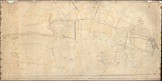
| Title: | Plan and section of part of the River South Medwin, between Walstonmill and Newholm, and the adjoining bogs under drainage, showing the proposed cut and principal drains: 1829. |
| Imprint: | 1829 |
| Pagination: | 1 map; 52 x 102 cm |
| Shelfmark: | MS.27647 |
| Notes: | This map is from our Lockharts of Lee Estate mapping collection. |
| Zoom Into Map: | Click on the map to view in greater detail. |