Plans of the Property of William Forbes Esq. of Callendar, 1800-1817
This volume contains 50 estate plans relating to the Earlstoun Estate, situated primarily in Dalry and Kells parishes in Kirkcudbrightshire, and Glencairn in Dumfries-shire. (There are also lands near Whitletts ("Sanquhar Lands"), to the north-east of Ayr). This estate was owned by William Forbes of Callendar (1756-1823), and the plans were surveyed by James Anderson, a civil engineer, architect and surveyor, based in Shandwick Place, Edinburgh. Anderson trained under James Jardine (1776-1858) and he superintended the work of James Knox. The plans were surveyed in 1800, and most were drafted in 1816-1817. The plans are ordered geographically in sections below, each prefaced by a title page and smaller scale overview map of the specific farms that follow as individual maps.
See also, Earlstoun estate plans, 1769-1830 for earlier plans of some of these farms, and Particulars of Sale of Portions of the Agricultural and Sporting Estate of Earlstoun ..., ca. 1920 for later plans.
We are very grateful to the Dumfries Archival Mapping Project for scanning these maps.
Volume contents - Plans of the Property of William Forbes Esq. of Callendar
Title page and index
- Plans of the Property of William Forbes Esq. of Callendar: Title Page
- Plans of the Property of William Forbes Esq. of Callendar: Index
Kells and Dalry parishes
- View georeferenced layer of these plans.
- Plans of the Property of William Forbes Esq. of Callendar: Title Page
- Plans of the Property of William Forbes Esq. of Callendar: Principal Plan of the Property of William Forbes Esqre. Of Callendar Situate in the Stewartry of Kirkcudbright and County of Dumfries
- Plans of the Property of William Forbes Esq. of Callendar: Plans of the Farms of Strangassill, Todston, Mosscroft, The Barleas, Ardock, Earlstoun, Barskeoch-Mains, Waterside, Cavan, Greenloop, Hannastoun, Barchoak, Over-Barskeoch, Knocksheen.
- Plans of the Property of William Forbes Esq. of Callendar: Strangassill
- Plans of the Property of William Forbes Esq. of Callendar: Knocksheen & Over Barskeoch
- Plans of the Property of William Forbes Esq. of Callendar: Barchoak, Greenloop and Hannistoun
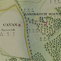
- Plans of the Property of William Forbes Esq. of Callendar: Cavan and Barskeoch Mains
- Plans of the Property of William Forbes Esq. of Callendar: Waterside
- Plans of the Property of William Forbes Esq. of Callendar: Earlstoun
Dalry parish
- New: April 2023 - View georeferenced layer of these plans.
- Plans of the Property of William Forbes Esq. of Callendar: Title Page
- Plans of the Property of William Forbes Esq. of Callendar: Ardoch
- Plans of the Property of William Forbes Esq. of Callendar: Todston & Mosscroft
- Plans of the Property of William Forbes Esq. of Callendar: The Barlae's
- Plans of the Property of William Forbes Esq. of Callendar: Plans of the Farms of Arndarroch, Bridgemark, Garriard, Culmark, New Mill, Marskaig, Cairneyhill, Blackmark, Auchenshinnoch, Fingland, Cornharrow, Little-Corlea, Cairoch, Craiglour
- Plans of the Property of William Forbes Esq. of Callendar: Arndarroch
- Plans of the Property of William Forbes Esq. of Callendar: Bridgemark, Garriard and New Mill
- Plans of the Property of William Forbes Esq. of Callendar: Culmark
- Plans of the Property of William Forbes Esq. of Callendar: Marskaig & Cairney-Hill
- Plans of the Property of William Forbes Esq. of Callendar: Blackmark
- Plans of the Property of William Forbes Esq. of Callendar: Auchenshinnoch
- Plans of the Property of William Forbes Esq. of Callendar: Fingland
- Plans of the Property of William Forbes Esq. of Callendar: Cairoch
- Plans of the Property of William Forbes Esq. of Callendar: Craiglour
- Plans of the Property of William Forbes Esq. of Callendar: Cornharrow
- Plans of the Property of William Forbes Esq. of Callendar: Little Curlae
Kells parish
- New: April 2023 - View georeferenced layer of these plans.
- Plans of the Property of William Forbes Esq. of Callendar: Title Page
- Plans of the Property of William Forbes Esq. of Callendar: General Plan of the Farms Lorg & Altrye, Curlae & Blackcraig, Auchrae & Polchaskie, Manwhill & Benbrack, Stronpatrick Stronfreggan & Little Auchrae
- Plans of the Property of William Forbes Esq. of Callendar: Lorg
- Plans of the Property of William Forbes Esq. of Callendar: Altrye
- Plans of the Property of William Forbes Esq. of Callendar: Curlae & Blackcraig
- Plans of the Property of William Forbes Esq. of Callendar: Auchrae & Polchaskie
- Plans of the Property of William Forbes Esq. of Callendar: Manwhill & Banbreck
- Plans of the Property of William Forbes Esq. of Callendar: Stronpatrick Stronfreggan and Little Auchrae
- Plans of the Property of William Forbes Esq. of Callendar: Plan of the Farms of Largmore, Duckiestoun, Ringreoch, Burnhead, Clannery, Drumbuie, Lochspraig
- Plans of the Property of William Forbes Esq. of Callendar: Burnhead
- Plans of the Property of William Forbes Esq. of Callendar: Duckiestoun and Ringreoch
- Plans of the Property of William Forbes Esq. of Callendar: Clannery
- Plans of the Property of William Forbes Esq. of Callendar: Largmore
- Plans of the Property of William Forbes Esq. of Callendar: Western Division of Drumbuie
- Plans of the Property of William Forbes Esq. of Callendar: Middle Division of Drumbuie
- Plans of the Property of William Forbes Esq. of Callendar: Eastern Division of Drumbuie
- Plans of the Property of William Forbes Esq. of Callendar: Lochspraig
- Plans of the Property of William Forbes Esq. of Callendar: Plans of the farms of Backhill of Burnhead Garvorie
- Plans of the Property of William Forbes Esq. of Callendar: Backhill of Burnhead
- Plans of the Property of William Forbes Esq. of Callendar: West Division of Garvorie
- Plans of the Property of William Forbes Esq. of Callendar: Middle Division of Garvorie
- Plans of the Property of William Forbes Esq. of Callendar: East Division
- Plans of the Property of William Forbes Esq. of Callendar: South Division of Garvorie
Glencairn and St Quivox parishes
- Plans of the Property of William Forbes Esq. of Callendar: Title Page
- Plans of the Property of William Forbes Esq. of Callendar: Plan of the Farms of Auchenstroan, Stranshalloch, Niess, Ballinie, Castlefairn
- Plans of the Property of William Forbes Esq. of Callendar: Auchenstroan
- Plans of the Property of William Forbes Esq. of Callendar: Stranshalloch
- Plans of the Property of William Forbes Esq. of Callendar: Niess and Ballinnie
- Plans of the Property of William Forbes Esq. of Callendar: Castlefairn
- Plans of the Property of William Forbes Esq. of Callendar: Sanquhar Lands