Plans and profiles of bridges, 18th-20th centuries
| Field | Content |
|---|---|
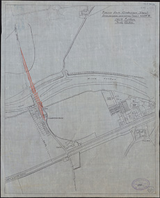
| Title: | Tracing from Ordnance sheet Stirlingshire, new series... N XXIV. 16, 1915 edition, scale 1/2500 [with the position of the proposed new Kerse Bridge added in red] |
| Imprint: | Drawn 1931. |
| Pagination: | 1 map ; 505 x 406 mm |
| Shelfmark: | EMS.s.281 |
| Zoom Into Map: | Click on the map to view in greater detail. |