Estate Maps, 1750s-1900s

| Name: | McKinlay, John, fl. ca 1805-1820 ? |
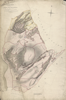
| Title: | The Farm Consisting of Kirland Drumcroy, Auchenfloor, Cannee, Barhill and Silvercraigs (formerly Nuntons) |
| Imprint: | ca. 1808-1815 |
| Pagination: | 1 map: col., 86.2 × 57.9 cm |
| Notes: | Inscribed in pen and black ink, upper left: "THE FARM | Consisting of | KIRLAND DRUMCROY | Auchenfloor Cannee | BARHILL & SILVERCRAIGS"; in pen and black ink, loer left: "GRAINGE"; in pen and black ink, lower right: "BANKS"; in pen and black ink, upper right: "MEIKLE KIRKLAND"; in pen and black ink, throughout, plots numbered "1" to "50" and some labeled; in graphite, lower right, some rates given. Watermark:(similar to Heawood 3457): J WHATMAN/ [illeg] From A Collection of Surveys of Scottish Estates of the Earl of Selkirk (ca. 1808-1815). Courtesy of the Yale Centre for British Art through the Dumfries Archival Mapping Project. |
| Zoom Into Map: | Click on the map to view in greater detail. |