Ordnance Survey, 1:25,000 maps of Great Britain - 1945-1973
In this section
- Content, Sources and Users
- Printing, Sheet Numbering and Later History
Printing

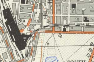
and public buildings in black, 1956
The Provisional edition was printed using four colours: black detail for text and bolder outlines, grey for field boundaries, vegetation, and building infill, orange-brown for contours, road infill and sand, and blue for water. There was initially no green plate, with woods indicated by tree symbols, but a green printing plate was used for the 'Regular edition' sheets of the 1:25,000 series from 1956.
Sheet extents and numbering
The 1:25,000 maps are based upon the Transverse Mercator projection, as recommended by the Ordnance Survey Davidson Committee which reported in 1938. Unlike the earlier Cassini projections, also used by the War Office in GSGS 3906 and in the County Series, the Transverse Mercator projection is orthomorphic, so that angles are not distorted. This is particularly valuable for artillery purposes. The Transverse Mercator metric grid was known successively as the Ordnance Survey Grid, and (by 1944), as the National Grid.

Each standard sheet covers 10 x 10 square kilometres on the ground and measures 40 x 40 cm within the map neat lines, about 56 x 49 cm as a full sheet with the margins. The sheet numbers reflect the particular 10 kilometre square of the National Grid that they show. Until 1951, these sheet numbers took the numeric form of the National Grid 100 kilometre squares (eg. 36/27 covering Edinburgh), but later took the alphabetic 100 kilometre squares (eg. NT 27 covering Edinburgh). There are also larger 'outsize' sheets with extended sheet lines in coastal areas, and some coastal sheets also have insets for islands.
View the sheet extents with a graphic index.
Later history - Pathfinders and Outdoor Leisure maps
From 1965, the 1:25,000 series was issued in a standard 20 x 10 km size, in what became known as the 'Second series', and (from 1979) as the Pathfinder series. The colour scheme and detail was revised, and showed more comprehensive footpath information from County Councils. From 1972 even larger sheets at 1:25,000 were issued for popular walking areas and National Parks, known as the Outdoor Leisure series. From 1994, these were complemented by the Explorer series for all other areas, which covered on average three times the area of their predecessor Pathfinders.
Further reading
Roger Hellyer. A guide to the Ordnance Survey 1:25,000 First Series (London: Charles Close Society, 2003). This includes a detailed introductory essay by Richard Oliver on the history and development of the 1:25,000 series, and a detailed carto-bibliography of sheets.
