Military Maps of Scotland (18th century)
Your search returned 22 records.
Ordered chronologically (undated items first).
| Field | Content | |
|---|---|---|
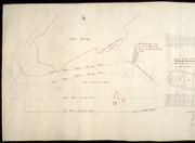
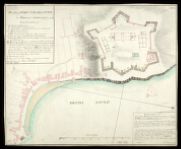
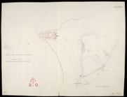
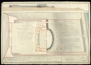
| Title: | [Shore at Fort George showing tides]; Plan of the Pier | |
| Name: | Frazer, Andrew (Engineer) Frazer, Andrew (Draughtsman) | |
| Survey: | [post-1756] | |
| Shelfmark: | MS.1647 Z.02/58 | |
| Field | Content | |
|---|---|---|
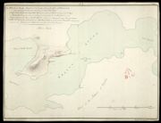
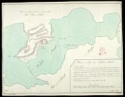
| Title: | Sketch of the Ground in the Neighbourhood of Fort William, in the Shire of Inverness, and the Point of Corpach. | |
| Name: | [Frazer, Andrew (Engineer)] | |
| Survey: | Post-1780 | |
| Shelfmark: | MS.1649 Z.03/46 | |
| Field | Content | |
|---|---|---|
| Title: | Plan of Fort Charlotte in March 1781 No. 1; Section from A to B in March 1781; Section from A to B January 1783 | |
| Name: | Frazer, Andrew (Engineer) | |
| Survey: | 1783 | |
| Shelfmark: | MS.1649 Z.03/48a | |
| Field | Content | |
|---|---|---|
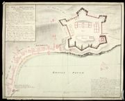
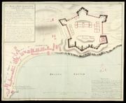
| Title: | Plan of Fort Charlotte at Lerwick in Shetland No. 2 Jany. 1783 | |
| Name: | Frazer, Andrew (Engineer) | |
| Survey: | 1783 | |
| Shelfmark: | MS.1649 Z.03/42a | |
| Field | Content | |
|---|---|---|
| Title: | Plan of Fort Charlotte at Lerwick in Shetland Jan. 1783 [copy] | |
| Name: | Frazer, Andrew (Engineer) | |
| Survey: | 1783 | |
| Shelfmark: | MS.1649 Z.03/42b | |
| Field | Content | |
|---|---|---|
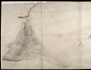
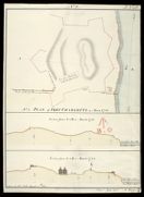
| Title: | Plan of Brassa-Sound in the Southern Part of the Isles of Shetland, and Survey of the Grounds adjoining to Fort Charlotte, No.4 | |
| Name: | Frazer, Andrew (Engineer) | |
| Survey: | 1783 | |
| Shelfmark: | MS.1649 Z.03/43a | |
| Field | Content | |
|---|---|---|
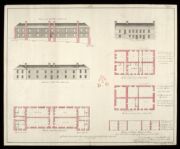
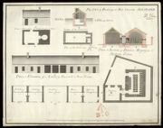
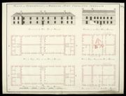
| Title: | [Plans, Elevations and Sections of the North Pile of Barracks, the West Pile of Barracks, and the Artillery Shed, at Fort Charlotte, Lerwick, Shetland] No. 3 | |
| Name: | Frazer, Andrew (Engineer) | |
| Survey: | 1783 | |
| Shelfmark: | MS.1649 Z.03/55 | |
| Field | Content | |
|---|---|---|
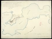
| Title: | [Map of the Moray Firth showing Ardersier Point and Fort George, and Chanonry Point, Fortrose and Rosemarkie] | |
| Name: | Frazer, Andrew | |
| Survey: | 1785 | |
| Shelfmark: | MS.1650 Z.47/21 | |
| Field | Content | |
|---|---|---|
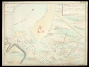
| Title: | Sketch of the Ground about Fort George | |
| Name: | Frazer, Andrew (Engineer) | |
| Survey: | 1785? | |
| Shelfmark: | MS.1646 Z.02/35b | |
| Field | Content | |
|---|---|---|
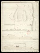
| Title: | Sketch of the loop-holed walls built round the Castles of Cargarff & Braemar in 1749 | |
| Name: | Frazer, Andrew (Engineer) | |
| Survey: | 1785 | |
| Shelfmark: | MS.1649 Z.03/36a | |
| Field | Content | |
|---|---|---|
| Title: | Sketch of the loop-holed walls built round the Castles of Cargarff and Braemar in 1749 [copy] | |
| Name: | Frazer, Andrew (Engineer) | |
| Survey: | 1785 | |
| Shelfmark: | MS.1649 Z.03/36b | |
| Field | Content | |
|---|---|---|
| Title: | Sketch of the loop-holed walls built round the Castles of Cargarff and Braemar in 1749 [copy] | |
| Name: | Frazer, Andrew (Engineer) | |
| Survey: | 1785 | |
| Shelfmark: | MS.1649 Z.03/36c | |
| Field | Content | |
|---|---|---|
| Title: | Plan of the Inclosed Battery or Redoubt near Leith built for the Protection of the Harbour in the year 1780 | |
| Name: | Frazer, Andrew (Engineer) | |
| Survey: | 1785 | |
| Shelfmark: | MS.1649 Z.03/40b | |
| Field | Content | |
|---|---|---|
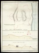
| Title: | Plan of the Bay called Brassa Sound [1783] [copy] | |
| Name: | Frazer, Andrew (Engineer) Dodd, Pressick (Copyist) | |
| Survey: | 1786 | |
| Shelfmark: | MS.1649 Z.03/43b | |
| Field | Content | |
|---|---|---|
| Title: | Plan of Buildings at Fort Charlotte Shetland | |
| Name: | Frazer, Andrew (Engineer) | |
| Survey: | 1786 | |
| Shelfmark: | MS.1649 Z.03/44a | |
| Field | Content | |
|---|---|---|
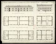
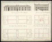
| Title: | Plans & Elevations of the Barracks at Fort Charlotte Shetland | |
| Name: | Frazer, Andrew (Engineer) | |
| Survey: | 1786 | |
| Shelfmark: | MS.1649 Z.03/44b | |
| Field | Content | |
|---|---|---|
| Title: | Plans and Elevations of the Barracks at Fort Charlotte Shetland [1786] [copy] | |
| Name: | Frazer, Andrew (Engineer) Dodd, Pressick (Copyist) | |
| Survey: | 1787 | |
| Shelfmark: | MS.1649 Z.03/44c | |
| Field | Content | |
|---|---|---|
| Title: | Plans and Elevations of the Barracks at Fort Charlotte Shetland [1786] [copy] | |
| Name: | Frazer, Andrew (Engineer) | |
| Survey: | 1787 | |
| Shelfmark: | MS.1649 Z.03/44d | |
| Field | Content | |
|---|---|---|
| Title: | Plan of Fort Charlotte in March 1781 No. 1; Section from A to B in March 1781; Section from A to B January 1783 [copy] | |
| Name: | Frazer, Andrew (Engineer) Field, John (Copyist) | |
| Survey: | 1812 | |
| Shelfmark: | MS.1649 Z.03/48b | |
| Field | Content | |
|---|---|---|
| Title: | Plan of Fort Charlotte in March 1781 No. 1; Section from A to B in March 1781; Section from A to B January 1783 [copy] | |
| Name: | Frazer, Andrew (Engineer) Field, John (Copyist) | |
| Survey: | 1812 | |
| Shelfmark: | MS.1649 Z.03/48c | |
| Field | Content | |
|---|---|---|
| Title: | Plan of Brassa Sound in the Southern Part of the Isles of Shetland, and Survey of the Grounds adjoining to Fort Charlotte [1783] [copy] | |
| Name: | Frazer, Andrew (Engineer) Fisher, T. (Copyist) | |
| Survey: | 1812 | |
| Shelfmark: | MS.1649 Z.03/43c | |
| Field | Content | |
|---|---|---|
| Title: | Plan of Fort Charlotte at Lerwick in Shetland No. 2 Jany. 1783 [copy] | |
| Name: | Frazer, Andrew (Engineer) Lewis, W. (Copyist) | |
| Survey: | 1812 | |
| Shelfmark: | MS.1649 Z.03/42c | |