Military Maps of Scotland (18th century)
Your search returned 4 records.
Ordered chronologically (undated items first).
| Field | Content | |
|---|---|---|
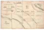
| Title: | Battle of Preston: - September 1745. (A plan of the victory of Falkirk Muir fought the afternoon of January 16 [sic, ie. 17th] 1746. - Battle of Clifton Muir, Westmorland. 18th December 1745). | |
| Survey: | ca. 1746 | |
| Shelfmark: | EMS.s.164 | |
| Field | Content | |
|---|---|---|
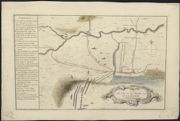
| Title: | A plan of the battle near Falkirk, Friday 17th Janr. 1746. | |
| Survey: | 1746 | |
| Shelfmark: | EMS.s.160 | |
| Field | Content | |
|---|---|---|
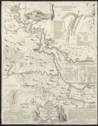
| Title: | A Map of the River Forth, from Stirling to Barroustouness, including Linlithgow, Falkirk, and the countries adjacent, with the route of both armies to the field of battle. / T. Jefferys sculp.. | |
| Name: | Jefferys, Thomas | |
| Survey: | 1746 | |
| Shelfmark: | EMS.s.161 | |
| Field | Content | |
|---|---|---|
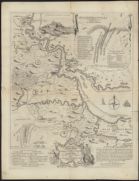
| Title: | A Map of the River Forth, from Stirling to Barroustouness, including Linlithgow, Falkirk, and the countries adjacent, with the route of both armies to the field of battle. / T. Jefferys sculp.. | |
| Name: | Jefferys, Thomas | |
| Survey: | 1746 | |
| Shelfmark: | EMS.s.794 | |