Military Maps of Scotland (18th century)
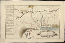
| Title: | A plan of the battle near Falkirk, Friday 17th Janr. 1746. |
| Description: | 1 map ; 251 x 399 mm |
| Original Survey: | 1746 |
| Date on Map: | 1746 |
| Placename: | Falkirk |
| Parish: | Falkirk |
| County: | Stirlingshire |
| Shelfmark: | EMS.s.160 |
| Zoom Into Map: | Click on the map to view in greater detail. |
All images © National Library of Scotland