Military Maps of Scotland (18th century)
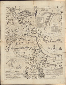
| Title: | A Map of the River Forth, from Stirling to Barroustouness, including Linlithgow, Falkirk, and the countries adjacent, with the route of both armies to the field of battle. / T. Jefferys sculp.. |
| Name: | Jefferys, Thomas |
| Description: | 1 map ; 39 x 36 cm., on sheet 52 x 40 cm |
| Original Survey: | 1746 |
| Date on Map: | 1746 |
| Placename: | Falkirk |
| Parish: | Falkirk |
| Shelfmark: | EMS.s.794 |
| Zoom Into Map: | Click on the map to view in greater detail. |
All images © National Library of Scotland