Mapmakers
Your search for Swire, William returned 2 records.
Ordered chronologically (undated items first).
| Field | Content | |
|---|---|---|
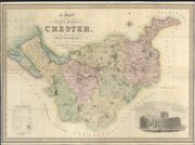
| Name: | Swire, William. Hutchings, W. F | |
| Title: | A map of the county palatine of Chester, divided into hundreds & parishes, from an accurate survey, made in the years 1828 and 1829 | |
| Imprint: | London : H. Teesdale & Co., 1830 | |
| Zoom Into Map: | Click on the map to view in greater detail. | |
| Field | Content | |
|---|---|---|
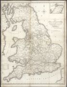
| Name: | Swire, William. | |
| Title: | Map of the canals and navigable rivers in England, Wales and Scotland : completed from the latest & best authorities for Baines' Lancashire / by William Swire. | |
| Imprint: | [Manchester : sn 1888]. | |
| Zoom Into Map: | Click on the map to view in greater detail. | |