Canal plans of Scotland, 18th-20th centuries
| Field | Content |
|---|---|
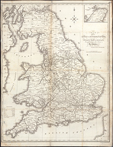
| Name: | Swire, William. |
| Title: | Map of the canals and navigable rivers in England, Wales and Scotland : completed from the latest & best authorities for Baines' Lancashire / by William Swire. |
| Imprint: | [Manchester : sn 1888]. |
| Pagination: | 1 map ; 56 x 43 cm |
| Shelfmark: | RSGS.29[41] |
| Zoom Into Map: | Click on the map to view in greater detail. |