Mapmakers
Your search for Bryant, A returned 6 records.
Ordered chronologically (undated items first).
| Field | Content | |
|---|---|---|
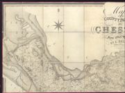
| Name: | Bryant, Andrew | |
| Title: | Map of the county palatine of Chester from an actual survey made in the years 1829, 1830 & 1831 | |
| Subtitle: | North-west sheet | |
| Imprint: | London : A. Bryant, 1831 | |
| Zoom Into Map: | Click on the map to view in greater detail. | |
| Field | Content | |
|---|---|---|
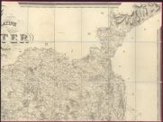
| Name: | Bryant, Andrew | |
| Title: | Map of the county palatine of Chester from an actual survey made in the years 1829, 1830 & 1831 | |
| Subtitle: | North-east sheet | |
| Imprint: | London : A. Bryant, 1831 | |
| Zoom Into Map: | Click on the map to view in greater detail. | |
| Field | Content | |
|---|---|---|
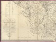
| Name: | Bryant, Andrew | |
| Title: | Map of the county palatine of Chester from an actual survey made in the years 1829, 1830 & 1831 | |
| Subtitle: | South-west sheet | |
| Imprint: | London : A. Bryant, 1831 | |
| Zoom Into Map: | Click on the map to view in greater detail. | |
| Field | Content | |
|---|---|---|
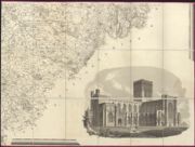
| Name: | Bryant, Andrew | |
| Title: | Map of the county palatine of Chester from an actual survey made in the years 1829, 1830 & 1831 | |
| Subtitle: | South-east sheet | |
| Imprint: | London : A. Bryant, 1831 | |
| Zoom Into Map: | Click on the map to view in greater detail. | |
| Field | Content | |
|---|---|---|
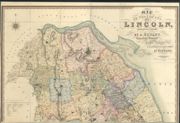
| Name: | Bryant, A. | |
| Title: | Map of the County of Lincoln, from an actual survey made in the years 1825-26 & 27 | |
| Subtitle: | North sheet | |
| Imprint: | London : A. Bryant, 1828 | |
| Zoom Into Map: | Click on the map to view in greater detail. | |
| Field | Content | |
|---|---|---|
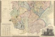
| Name: | Bryant, A. | |
| Title: | Map of the County of Lincoln, from an actual survey made in the years 1825-26 & 27 | |
| Subtitle: | South sheet | |
| Imprint: | London : A. Bryant, 1828 | |
| Zoom Into Map: | Click on the map to view in greater detail. | |