County maps, 1580s-1950s
| Field | Content |
|---|---|
| Name: | Bryant, A. |
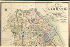
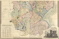
| Title: | Map of the County of Lincoln, from an actual survey made in the years 1825-26 & 27 |
| Imprint: | London : A. Bryant, 1828 |
| Pagination: | 1 map on 2 sheets ; sheets ca. 111 x 163 cm (ca. 64 x 80 inches) |
| Notes: | Scale: ca. 1 inch to a mile. |
| Shelfmark: | EME.b.3.41 |
| Zoom Into Map: | Click on the maps below to order image or view in greater detail. |
 |
 |