Estate Maps, 1750s-1900s
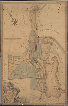

| Name: | Gillone, John, 1767-1809 |
| Title: | A Plan of the Burgh and Burgh Lands of Castle Douglas |
| Imprint: | January 1795 |
| Pagination: | 1 manuscript map: col.; 83 x 53 cm. |
| Shelfmark: | GGD436/18 |
| Notes: | Courtesy of the Ewart Library through the Dumfries Archival Mapping Project. View georeferenced map. |
| Zoom Into Map: | Click on the map to view in greater detail. |