Estate Maps, 1750s-1900s
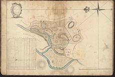

| Name: | Dunbar, William, fl. 1767-1815 |
| Title: | A Plan of Holm |
| Imprint: | September 1799 |
| Pagination: | 1 manuscript map : col.; 47 x 67 cm. |
| Shelfmark: | 136b |
| Notes: | Courtesy of Kirkcudbright Museum through the Dumfries Archival Mapping Project - view futher details. View georeferenced map. |
| Zoom Into Map: | Click on the map to view in greater detail. |