Estate Maps, 1750s-1900s

| Name: | McKinlay, John, fl. ca 1805-1820 ? |
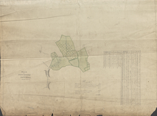
| Title: | Plan of Drumore and How-well Meadows - A Collection of Surveys of Scottish Estates of the Earl of Selkirk |
| Imprint: | 1815 |
| Pagination: | 1 map: col., 64.1 × 84.3 cm |
| Notes: | Inscribed in pen and black ink, lower left: "PLAN | of | HOW-WELL | Meadows &c"; in pen and black ink, lower center, list of "Remarks" and dimensions: "Full front fixed mark to bottom of burn at A 9 ft 7In.s | D.o from ... D.o to bottom of burn at Stepend bridge 16.5 | D.o from ... D.o to Key stone of Stepend Bridge... 12.8 | D.o at Dike bottom of burn ... 26.3 | Distance from A to stepend bridge... 509 yards | From stepend bridge to Dike... 311 [yards] | From Dike to Q... 130 [yards] | Total 930 [yards]"; in pen and black ink, center, ground plan labeled; in pen and black ink, lower right, list of plots and corresponding dimensions. Watermark:(similar to Heawood 3460) J WHATMAN/ 1811. Dated in pen and black ink, lower left: "1815"; not signed From A Collection of Surveys of Scottish Estates of the Earl of Selkirk (ca. 1808-1815). Courtesy of the Yale Centre for British Art through the Dumfries Archival Mapping Project. |
| Zoom Into Map: | Click on the map to view in greater detail. |