Estate Maps, 1750s-1900s

| Name: | McKinlay, John, fl. ca 1805-1820 ? |
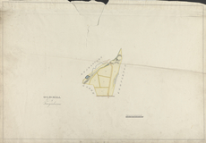
| Title: | Old Mill of Twynhame - A Collection of Surveys of Scottish Estates of the Earl of Selkirk |
| Imprint: | ca. 1808-1815 |
| Pagination: | 1 map: col., 57.8 × 83.2 cm |
| Notes: | Inscribed in pen and black ink, lower left: "OLD MILL | of | Twynhame"; in pen and black ink, center: "BEARLOCUEN"; in pen and black ink, center: "GLEBE"; in pen and black ink, center: "KEMPLETON"; in pen and black ink, center: "from Twynhame to Tarf Bridge"; in pen and black ink, center, labeled "1" to "6", "A" and "B"; in pen and black ink, center: "Old Mill"; in pen and black ink, lower right, bar scale labeled: "Scale of chains of 74 feet each" and numbered "0" to 10" From A Collection of Surveys of Scottish Estates of the Earl of Selkirk (ca. 1808-1815). Courtesy of the Yale Centre for British Art through the Dumfries Archival Mapping Project. |
| Zoom Into Map: | Click on the map to view in greater detail. |