Estate Maps, 1750s-1900s

| Name: | Howatson, John, active 1813 |
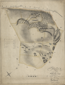
| Title: | Farm of Highbanks - A Collection of Surveys of Scottish Estates of the Earl of Selkirk |
| Imprint: | 1813 |
| Pagination: | 1 map: col., 47.3 × 37.5 cm |
| Notes: | Inscribed in pen and black ink over graphite, lower right: "Plan | of the Farm of | HIGHBANKS | the Property of | The Right Honble the Earl | of | Selkirk | Possessed by John Currie"; in pen and black ink, center left: ["Contents" key] and some notations in graphite. Signed and dated in pen and black ink, lower right: "Drawn by John Howatson | for | John McKinlay | 1813" From A Collection of Surveys of Scottish Estates of the Earl of Selkirk (ca. 1808-1815). Courtesy of the Yale Centre for British Art through the Dumfries Archival Mapping Project. |
| Zoom Into Map: | Click on the map to view in greater detail. |