Estate Maps, 1750s-1900s

| Name: | McKinlay, John, fl. ca 1805-1820 ? |
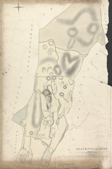
| Title: | Black - Stockarton - A Collection of Surveys of Scottish Estates of the Earl of Selkirk |
| Imprint: | ca. 1808-1815 |
| Pagination: | 1 map: col., 96.8 × 62.9 cm |
| Notes: | Inscribed in pen and black ink, lower right: "BLACK-STOCKARTON"; in pen and black ink, throughout, ground plan labeled and plots numbered "1" to 16"; in pen and black ink, lower right, bar scale labeled: "Scale of chains of 74 feet each", "1" to "10". Watermark:(not in Heawood, Shorter or Churchill) JAMES WHATMAN/ 1809 From A Collection of Surveys of Scottish Estates of the Earl of Selkirk (ca. 1808-1815). Courtesy of the Yale Centre for British Art through the Dumfries Archival Mapping Project. |
| Zoom Into Map: | Click on the map to view in greater detail. |