Estate Maps, 1750s-1900s

| Name: | McKinlay, John, fl. ca 1805-1820 ? |
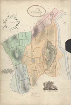
| Title: | Bishopton - A Collection of Surveys of Scottish Estates of the Earl of Selkirk |
| Imprint: | ca. 1808-1815 |
| Pagination: | 1 map: col., 84.1 × 57.5 cm |
| Notes: | Inscribed in pen and black ink, lower right: "BISHOPTON"; in pen and black ink, upper left: "Newton"; in pen and black ink, upper right: "Bank | of | Bishopton'; in pen and black ink, lower left: "CARHOW'"; in pen and black ink, center: "NEWTON"; in pen and black ink, center: "Mr Buchanan"; in pen and black ink, center: "LONGLAND"; in pen and black ink, center: "CUMSTONEND"; in pen and black ink, center: "KIRKCHRIST"; in pen and black ink, right: "RIVER DEE"; in pen and black ink, center, plots numbered and some labels given; in pen and black ink, bar scale labeled: "Scale | of Scotch Chains", numbers "1" to "10". Watermark: similar to Shorter 51 (EDMEADS & PINE/1802) From A Collection of Surveys of Scottish Estates of the Earl of Selkirk (ca. 1808-1815). Courtesy of the Yale Centre for British Art through the Dumfries Archival Mapping Project. |
| Zoom Into Map: | Click on the map to view in greater detail. |