Estate Maps, 1750s-1900s

| Name: | McKinlay, John, fl. ca 1805-1820 ? |
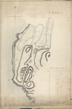
| Title: | Torrs - A Collection of Surveys of Scottish Estates of the Earl of Selkirk |
| Imprint: | 1808 |
| Pagination: | 1 map: col., 97.5 × 64.1 cm |
| Notes: | In pen and black and brown ink, throughout, plots labeled "No 1" to "No 19" with dimensions, corresponding to key in pen and brown ink, lower right, labeled: "Contents" and containing dimensions of "Arable", "Meadow", "Moss", "Wood" and "Total" land; in pen and brown ink, lower right: "House & Garden" and dimensions, "Road" and dimensions, "Double hedge row at Balmae march" and dimensions, "&c &c between No.s 10 & 13" and dimensions, and "Rocks along the Coast 28"0'0'", "Hight of [?]Knockshinny above the level of the sea 376 feet"; in pen and brown ink, lower left, bar scale labeled: "Scale of Four Chains 40 to the Inch", numbered "0" to "40"; in graphite, throughout, plots labeled with dates; in graphite, upper center, chart of areas of a road and corresponding dimensions. Watermark:(similar to Shorter 53) E & P. Signed and dated in pen and brown ink, lower right: "Surveyed June 1808 John Brown" From A Collection of Surveys of Scottish Estates of the Earl of Selkirk (ca. 1808-1815). Courtesy of the Yale Centre for British Art through the Dumfries Archival Mapping Project. |
| Zoom Into Map: | Click on the map to view in greater detail. |