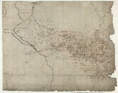
| Notes: | This is a large map, encompassing a substantial portion of the Midland Valley of Scotland. In the west the area is bounded by Loch Lomond, the Firth of Clyde, and the River Clyde, with Glasgow itself depicted. In the north, there is little information north of a line from Stirling in the east to Loch Lomond in the west. The now ragged eastern margin of the sheet includes Dunblane in the north and a point just west of Bo'ness in the south. From here the southern boundary runs irregularly across country to Glasgow. - Robert Gordon made substantial additions to this map. The grid drawn in red ink covers in the main the area mapped by Pont. This grid was probably drawn by Gordon as an aid to copying the map.
- There are two notes in Gordon's hand. One, in Strath Blane, south east of Loch Lomond, ays:
The Moss. heir
M.G. Buchanan was born This is a reference to George Buchanan (1506-1582) the renowned Scottish poet and historian. - Gordon's second and longer note, just west of Cumbernauld (lower centre), says:
this part joyneth not w[ith] [th]e rest
of [th]e Lennox but outthruch to it
be annextion it is cald [th]e
parochin of [th]e Leinyie - There is a neat archaeological note in Latin northeast of Glasgow. It says:
Vestigia valli Romanorum quod
videtur Agricolam aut Adrianum
Primum posuisse Which translates as: 'the remains of the Roman fortification which
it seems Agricola or Hadrian
first built' - The dotted line running west-east across the map represents the line of the Roman Antonine Wall. This turf wall across the Clyde-Forth isthmus was begun by the Roman governor Lollius Urbicus in about the year 142 AD in an attempt to separate the 'barbarians' from the Roman occupied lands to the south. The line may have been added by Gordon. Many stretches of ditch and/or rampart are still visible, including that in the grounds of Callendar House, Falkirk, which is shown by Pont.
- Pont 16 and Pont 17 overlap the western margin of this sheet, and Pont 34 the southern margin. Pont's map of Linlithgowshire (Pont <36>(4))includes part of the far east, south of the Forth.
- The following manuscript maps by Robert Gordon include at least part of Pont 32: 2, 6, 48, 49, 50, and 51.
- Joan Blaeu's map of Sterlinensis (1654) was strongly based on information contained in Pont 32. His Levinia is also relevant.
View the Pont Maps website. View maps by Blaeu and Robert and James Gordon. |