County maps, 1580s-1950s
| Field | Content |
|---|---|
| Name: | Pont, Timothy, 1560?-1614? |
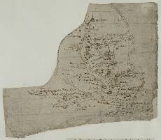
| Title: | [Lower Strath Tay from Dunkeld to Benchil] - Pont 25 (front) |
| Imprint: | [ca. 1583-96] |
| Pagination: | 1 manuscript map ; 18 x 20 cm. |
| Shelfmark: | Adv.MS.70.2.9 (Pont 25) |
| Notes: | This is the front of the manuscript known as Pont 25, which originally formed part of Pont 23. The map on it shows a stretch of the valley of the River Tay from the town of Dunkeld in the north (top), then east south east to the confluence of the Tay with the River Isla (lower right), at which point the Tay turns south east and is shown as far as Benchil. The map is orientated with west at the top of the sheet. Thus, the northern boundary of the mapped area is defined by the course of the Lownen (Lunan) River.
View the Pont Maps website. View maps by Blaeu and Robert and James Gordon. |
| Zoom Into Map: | Click on the map to view in greater detail. |