British First World War Trench Maps, 1915-1918
Sheet numbering and trench map references

View zoomable sheet index
Trench map sheet numbers and references are based on the Belgian 1:40,000 sheet lines, numbered from 1-72 to cover the whole territory of Belgium. As they were extended westwards into France, letter suffixes were added (eg. 36A, 36B, etc.) as shown in the index map to the right.
For more detailed scales, each 1:40,000 sheet was divided into four 1:20,000 sheets with NW, NE, SW and SE suffixes to the main 1:40,000 sheet number (eg. 36NW, 36NE, etc.).
Each 1:20,000 sheet was in turn divided into four 1:10,000 sheets with the numbers 1 to 4 as suffixes to the main 1:20,000 sheet number (eg. 36NW1, 36NW2, etc.).

(28NW, 28NE, 28SW and 28SE - red) which each contain 4
1:10,000 sheets (eg. 28SE1, 28SE2, 28SE3, 28SE4 - blue)
Larger-scale sheets at 1:5,000 were not part of a standard series and were often given special names of their main location (eg. Eaucourt l'Abbaye ).
Trench map references use the main map sheet numbers described above, and divide the standard Belgian 1:40,000 sheet into 5,000 or 6,000 square yard capital letters, running from A to X. Each 5,000-6,000 square yard area was then divided into 1,000 square yard areas, numbered from 1-36, which were quartered into four 500 yard sub-squares, a-d.
For example, a reference such as Sheet 36NW,C23c7.4 gives first the 1:20,000 sheet number, then the 5000 yard square letter C, the 1,000 yard square number (23), the 500 yard sub-square letter c, the easting in tenths (7) and the northing in tenths (4). This locates a position just east of Armentieres
Although there was an earlier trench map grid system which subdivided each 1:40,000 sheet into regular 5,000 yard squares in 1914, it was quickly superseded and is not used on any of the maps on this website. The new system described above was sometimes marked “Revised system of squaring” on sheets.
Search using trench map coordinates
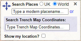
Our Map Finder - with Outlines and Georeferenced Maps viewers allow you to Search Trench Map Coordinates in the search panel to the upper left. You can input various lengths of trench map coordinates (eg. '28.I.8', '36C.S.22.c', '62d.J.19.b.4.3') and the map will zoom to these locations. The longer your reference, the more accurate the location will be.
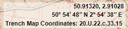
In our Map Finder - with Outlines and Georeferenced Maps viewers, the Trench Map Coordinates for your mouse cursor location are shown to the lower right. If you click/tap on the 'Show Coordinates' tab in the footer, or hold the ALT button down and click/tap, these Trench Map Coordinates and the latitude / longitude coordinates of the place you have clicked/tapped on, appear in a popup box for copying.
We are very grateful to Bill Frost, developer of the tMapper website for sharing these trench map coordinate search and conversion utilities with us.
The tMapper website provides an easy conversion utility from trench map references to modern locations. It also includes a searchable gazetteer of trench names, and related resources and information.
'The Great War, 1914-1918' has an excellent guide explaining why the British Army required the Trench Maps at this scale, how the map reference system was devised and how to find a location using a trench map reference.
NLS collection
This website presents scanned images of all the maps held by NLS within the main two series of trench maps: GSGS 2742 (1:20,000) and GSGS 3062 (1:10,000), as well as NLS holdings of all larger-scale trench maps of the Western Front too. It should be stressed that the NLS collection is very incomplete, and much more comprehensive collections can be found within The National Archives and the Imperial War Museum.
This website includes:
- 21 maps at 1:5,000 scale
- 88 maps at 1:10,000 scale
- 198 maps at 1:20,000 scale
- 1 map at 1:40,000 scale
These can be viewed as an ordered list by scale and date.
Identifying specific locations and battles
- For viewing original ungeoreferenced sheets of a place, use our Map Finder viewer and type a specific location in the Gazetteer / NG Ref: box, eg. ('Albert', 'Arras', 'Cambrai', 'Messines', 'Vimy', 'Ypres', etc.). Select the place you are interested in on the map and the sheets that cover the place appear in the left hand 'Results' column. Consult our Help guide for further guidance.
- For viewing georeferenced sheets of a place, use our Georeferenced Maps viewer. Type a specific location in the Search places box to zoom to a place, or zoom in on an area of interest. The coverage of our georeferenced maps is shown with a blue shaded overlay with relevant Trench Map sheet numbers, and all those that cover the area on the map are listed in the left hand Select a map group: drop-down list. Select those of interest and if they are not on screen, click the 'Zoom to this historic map overlay' link. The transparency of the historic maps can be adjusted to compare them to modern day satellite and map images, and they can also be compared to each other using the Side by side view link. Consult our Help guide for further guidance.

to be compared to each other and to the present day
Further reading
Chasseaud, Peter, Artillery's astrologers : a history of British survey & mapping on the Western Front 1914-1918. Lewes: Mapbooks, 1999.
Chasseaud, Peter, Mapping the First World War: the Great War through maps from 1914-1918. Glasgow; London : Collins, in association with Imperial War Museum, 2013.
Chasseaud, Peter, Rats Alley : trench names of the Western Front, 1914-1918. Staplehurst: Spellmount, 2006.
Chasseaud, Peter, Topography of Armageddon: A British Trench Map Atlas of the Western Front. Lewes: Mapbooks, 1991.
Forty, Simon, Mapping the first world war : battlefields of the great conflict from above. London: Conway, 2013.
Great Britain. War Office (G.S.G.S.) / Jack, E.M., Report on survey on the Western Front, 1914-18. London: HMSO, [1920].
Digital Resources and Links
British Trench Maps Ontology Specification. An RDF ontology to markup information on the British Trench Map Coordinate system used during the Great War. (Robert Warren, The Muninn Project)
Defence Surveyors Association - Notes on First World War surveying and related documents.
The Great War 1914-18 (greatwar.co.uk) - WW1 British Army Trench maps
Linesman trench map applications (Great War Digital)
The Long, Long Trail: the British Army in the Great War - images and details of campaign, battle and trench maps
Mapping the Front: Great War Trench Map DVD Collection (Western Front Association and Imperial War Museum)
Naval and Military Press / The National Archives British Trench Map Atlas, 1914-1918
 Previous: Page 1 of 2