Railway plans of Scotland, 18th-20th centuries
| Field | Content |
|---|---|
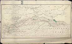
| Title: | Map of the country between Edinburgh and Glasgow.Showing the line of the proposed railway to connect these two cities.Wyld & Son Lith.Charing Cross, East London. |
| Imprint: | ca. 1830? |
| Pagination: | 1 map; 43 x 69 cm |
| Shelfmark: | Stevenson Parcel 3, 20 |
| Zoom Into Map: | Click on the map to view in greater detail. |