Town Plans / Views, 1580s-1940s
| Field | Content |
|---|---|
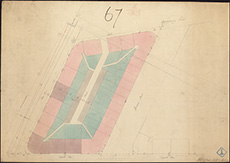
| Name: | Playfair, William Henry, 1790-1857 |
| Title: | Edinburgh - Plan of block of buildings between Elm Row, Leopold Place, Windsor Street and Montgomery Street |
| Imprint: | 1811 |
| Pagination: | 1 map : col.; 655 x 460 mm. |
| Shelfmark: | MS.5848, No.44 |
| Zoom Into Map: | Click on the map to view in greater detail. |
| Notes: | This map is from our Stevenson civil engineering plans collection. |