Town Plans / Views, 1580s-1940s
| Field | Content |
|---|---|
| Name: | Lizars, W. H. (William Home), 1788-1859 |
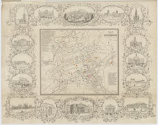
| Title: | Plan of Edinburgh |
| Imprint: | [Edinburgh: Oliver & Boyd, 1852] |
| Pagination: | 1 map: col.; 41 x 52 cm |
| Shelfmark: | EMS.b.3.1(17) |
| Zoom Into Map: | Click on the map to view in greater detail. |
| Notes: | This map, without the surrounding vignettes, was originally published in Edinburgh by Oliver & Boyd in the 19th edition of the Scottish Tourist in 1852. The map continued to be included in later editions of the Scottish Tourist, as well as other guidebooks to Edinburgh, as late as the 1890s. Lizars’s carefully and charmingly engraved vignettes of Edinburgh landmarks conveys something of the equivalency that developed in the 19th century between all tourist attractions and all others. Heriot’s Hospital, from the reign of Charles I, stands cheek-by-jowl with Donaldson’s Hospital, a gigantic retro-Elizabethan structure completed just one year before the map itself. The neo-Gothic buttresses of the Walter Scott Monument (1840-46) are likewise twinned with the actually medieval Gothic lantern spire of St Giles. At top centre, a lady with a parasol has the option of surveying either the genuine medieval battlements of Edinburgh Castle to her right, or the mock-medieval ones of the city’s Georgian prison to her left. William Home Lizars (1788-1859) was a talented artist and engraver, based from 1817 onwards in St James Square in Edinburgh, who also drafted and published some of the most commercially successful Scottish maps and atlases of the early 19th century. |