Town Plans / Views, 1580s-1940s
| Field | Content |
|---|---|
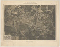
| Title: | Air - map of Salisbury. Compiled from Ordnance Survey plans and from air photographs. |
| Imprint: | Southampton : Ordnance Survey, 1919. |
| Pagination: | 1 map ; 457 x 660 mm. |
| Shelfmark: | Map.l.35.29 |
| Zoom Into Map: | Click on the map to view in greater detail. |
| Notes: | Scale 1:5,280 Inset: [Topographical map of the same area on a reduced scale] This experimental map was the first civilian map produced partly by aerial methods by Ordnance Survey. Aerial photography had proved its value for mapping and survey work during the First World War, and in 1919 Ordnance Survey were in close contact with the War Office and the Air Ministry over investigating the possibility of preparing plans of towns using air-photo mosaics. In practice, due to the differences in scale of the various air photographs comprising the mosaic covering Salisbury, the work was done by an artist, drawing the detail from the air photos onto a specially prepared topographic map. This map had been reduced from 1:2,500 sheets to twelves inches to the mile (1:5,280). The Ordnance Survey regarded the result as an "admirable artistic production", but without any outstanding points of interest, and the experiment underlined the huge amount of work which was still needed before aerial survey methods could be successfully used by Ordnance Survey (Seymour, 1980, pp. 234-35). |