Further information - Charles Goad Fire Insurance Plans of Scottish Towns, 1880s-1940s
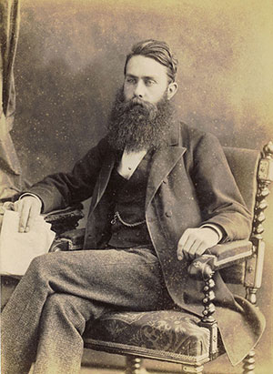
Charles Goad

Courtesy of the City of Vancouver Archives.
Charles Goad (1848-1910) was born in Surrey, but moved to Canada in 1869, working initially as a civil engineer on various railway projects. In 1875 he spotted a demand for street maps that specifically showed information related to the risk of fire, and set up the Charles E. Goad Company in Montreal. Assisted by teams of surveyors, Goad mapped streets and buildings at new levels of detail, specifically noting their construction materials, wall thickness, interior dimensions, room arrangement and function, type of roof, proximity to fire hydrants and fire-extinguishing appliances, and the locations of doors, windows and skylights. Building materials were colour-coded for flammability, so spatial concentrations of particular risks were immediately apparent. Initially, the business struggled and Goad continued his railway work, but soon it took off, and by the mid 1880s its series of large-scale insurance plans covered more than 1,300 places in Canada. There can be little doubt that Goad was influenced by the fire insurance maps of Daniel Alfred Sanborn (1827-83), who founded the Sanborn Map Company in New York in 1867, and Goad eventually bought out their Canadian interests.
In 1885, Goad returned to England and made London his base for a similarly comprehensive coverage of British towns and cities. He produced plans for a number of Scottish towns, including Campbeltown, Dundee, Edinburgh, Glasgow, Greenock, Leith, and Paisley between 1888 and 1896, with further updates after the turn of the century. He also expanded overseas, with plans produced for France, Denmark, Egypt, the Ottoman Empire, the West Indies, Venezuela, Chile, and South Africa. After his death in 1910, his three sons continued the business, which survived as an independent company until 1974 and still produces insurance-risk plans today, as part of the Experian Group.
Coverage and content

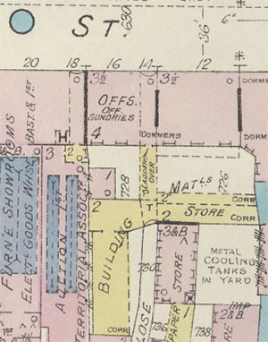
View original map.
Goad Fire Insurance plans usually cover just the main industrial areas of towns and cities. Through their own system of colour-coding, symbols and abbreviations, they provide a very detailed picture of the buildings in the area. Colour-coding allowed fire risk to be graphically portrayed: brick and stone buildings were shown in red, timber buildings in yellow, iron or metal buildings in grey, and skylights in blue (as are hydrants (H) and water valves (V) in the streets). The maps show very detailed information omitted from Ordnance Survey maps, including the function of each building (commercial, residential, educational etc.) and the height of the building. Through related abbreviations, the specific uses of each building are shown, such as tenements (TENS), dwellings (D), shops (S), halls, churches, and many types of manufacturing premises. Construction materials were identified to assess fire risk, as were special fire hazards, such as chemicals, combustable goods, steam engines, boilers, kilns, and ovens. Information could also indicate likely concentrations of people in a building, for example in factories, schools and places of worship. The width of streets, building numbers and water supplies are shown, as are various underground features, such as tunnels, cellars and basements. High-risk industrial facilities such as factories and mills, warehouses, and port and railway areas were given particular attention. The large scale of the plans (40 feet to one inch, or 1:480) allows very detailed information to be shown.
Drawing, publication and re-issue
Charles Goad employed teams of surveyors to gather information and draw the plans. There is no evidence that they directly used Ordnance Survey maps, which were at smaller scales, and generally lacked most of these internal building details. Goad sold the plans to fire insurance offices across Britain, who used them to evaluate fire risk and the consequent pricing of insurance policies. The plans were printed lithographically, often preceded by a Key Plan or graphic index sheet showing coverage, and sometimes including Street Index Sheets. ( View Edinburgh Key Plan and Street Index ).
Charles Goad issued their maps when they saw a demand for them, or a demand for updates. So after the initial survey of a town, sheets could be updated and new sheets could be added to extend geographic coverage at variable times from the 1880s to the 1960s. As a result, following the initial survey, there is no comprehensive revised edition of the sheets for any town at a later point in time. Where the demand continued, Goad often revised and re-issued their plans on a selective basis. The dates of these revisions are shown to the upper right of each map, and are included in our sheet information.
Goad plans were never legally deposited, as they were not considered "publications". The National Library of Scotland's Goad map collection was purchased from Charles E. Goad in 1989, comprising those original maps of Scottish towns and cities that were then available. This was selective in its coverage, and it is not a comprehensive set. We have scanned and put online all the sheets that we hold that are out-of-copyright, published over 70 years ago.
See also:
- British Library Goad Fire Insurance Plans. The British Library holds the most comprehensive collection of Goad plans available, having received all sheets published between 1895 and 1924.
Further information
- A. Feintuck, 'Constructing cartographic authority: the conceptualization and mapping of urban spaces in Edinburgh, c. 1880 – c. 1920', Urban History 46(3) (2019), pp.464-92.
- G. Rowley, British Fire Insurance Plans. Old Hatfield: Chas E. Goad, Ltd, 1984.
