Ordnance Survey large scale town plans, 1840s-1890s
Symbols
These are just a selection of the more common graphic features shown on these maps. For more information, please consult Richard Oliver's book Ordnance Survey maps: a concise guide for historians (London : Charles Close, 1993).
Buildings
 | Carmine colour = brick or stone |
 | Grey colour = iron or wood |
 | Blue and/or cross-hatched = glass |
 | Roofed archway/alleyway/passageway/vennel/wynd |
 | Interior layout and seating for public buildings |
 | Brick or stone wall |
Woodland
 | Single tree - various styles |
 | Mixed woodland |
 | Mixed woodland - different style |
 | Mixed woodland - different style |
 | Fir trees |
 | Oak trees |
 | Birch trees |
 | Brushwood and Bushes |
 | Furze |
 | Osiers |
Land
 | Shingle/pebbles |
 | Sand |
 | Moor |
 | Cliff/escarpment/quarry |
 | Flat rocks |
 | Sloping masonry |
 | Cutting - sloping downwards to water |
 | Embankment - sloping upwards to central path |
Heights
(in feet, above mean sea level, Liverpool)
 | Spot height/surface level of ground |
 | Benchmark (OS mark on building, wall, etc.) |
| Arrow to show direction of flowing water |
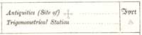
Antiquities and Trigonometrical points
 |
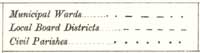
Boundaries
 |
 |