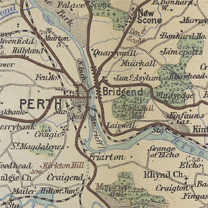
Johnston's "Three miles to inch" map of Scotland, ca. 1895-1912

These three sets of series maps of Scotland by the Edinburgh-based firm of W. & A.K. Johnston, covered all of Scotland in sixteen sheets at a scale of 'three miles to the inch' or 1:190,080. The scale is particularly useful for giving a regional overview of the landscape, showing the main travel infrastructure by rail, steamer or car. The initial series published from around 1895 coloured the counties in blocks of separate colour. The second series published from around 1898, highlighted county boundaries in colour, with roads, woodland and water features coloured in red, green and blue. The third series published around 1912, used hypsometric tints of colour to show altitude or relief, along similar lines to Bartholomew, from shades of green and beige for land close to sea level, to shades or orange and purple for higher mountains.
- View the maps with a graphic index of Scotland
The series was published from ca. 1895 through to 1920:
- W. & A. K. Johnston's "Three miles to inch" map of Scotland, ca. 1895-1905
- W. & A. K. Johnston's "Three miles to inch" map of Scotland, ca. 1898
- W. & A. K. Johnston's "Three miles to inch" map of Scotland, ca. 1900
- W. & A. K. Johnston's "Three miles to inch" map of Scotland, ca. 1908
- W. & A. K. Johnston's "Three miles to inch" map of Scotland, ca. 1912
W. & A. K. Johnston's "Three miles to inch" map of Scotland, ca. 1895-1905
These maps are held at the shelfmark: Newman.347.
| Sheet Number | Date of Publication |
|---|---|
| Sheet 1 | Published: ca. 1885-1905 |
| Sheet 2 | Published: ca. 1885-1905 |
| Sheet 3 | Published: ca. 1885-1905 |
| Sheet 4 | Published: ca. 1885-1905 |
| Sheet 5 | Published: ca. 1885-1905 |
| Sheet 6 | Published: ca. 1885-1905 |
| Sheet 8 | Published: ca. 1885-1905 |
| Sheet 9 | Published: ca. 1885-1905 |
| Sheet 10 | Published: ca. 1885-1905 |
| Sheet 11 | Published: ca. 1885-1905 |
| Sheet 12 | Published: ca. 1885-1905 |
| Sheet 13 | Published: ca. 1885-1905 |
| Sheet 13 | Published: ca. 1885-1905 |
| Sheet 14 | Published: ca. 1885-1905 |
| Sheet 15 | Published: ca. 1885-1905 |
| Sheet 15 | Published: ca. 1885-1905 |
| Sheet 16 | Published: ca. 1885-1905 |
| Sheet 16 | Published: ca. 1885-1905 |
W. & A. K. Johnston's "Three miles to inch" map of Scotland, 1898
These maps are held at the shelfmark: Map.s.21.23-38.
W. & A.K. Johnston's "Three miles to inch" map of Scotland, ca. 1900
| Sheet Number and Name | Date of Publication |
|---|---|
| W. & A.K. Johnston's "Three miles to inch" map of Scotland.. Sheet 6 | Published: ca. 1900 |
| W. & A.K. Johnston's "Three miles to inch" map of Scotland.. Sheet 10 | Published: ca. 1900 |
W. & A.K. Johnston's "Three miles to inch" map of Scotland, ca. 1908
| Sheet Number and Name | Date of Publication |
|---|---|
| W. & A.K. Johnston's "three mile to inch" cycling and automobile map for Edinburgh, Perth & Dundee districts. . | Published: ca. 1908 |
W. & A.K. Johnston's "Three miles to inch" map of Scotland, ca. 1912
These maps are held at the shelfmark: Map.s.24.37-52.
| Sheet Number and Name | Date of Publication |
|---|---|
| Sheet 1 | Published: 1912 |
| Sheet 2 | Published: 1912 |
| Sheet 3 | Published: 1912 |
| Sheet 4 | Published: 1912 |
| Sheet 5 | Published: 1912 |
| Sheet 6 | Published: 1912 |
| Sheet 6 | Published: 1912 |
| Sheet 7 | Published: 1912 |
| Sheet 8 | Published: 1912 |
| Sheet 9 | Published: 1912 |
| Sheet 10 | Published: 1912 |
| Sheet 11 | Published: 1912 |
| Sheet 12 | Published: 1912 |
| Sheet 13 | Published: 1912 |
| Sheet 13 | Published: 1912 |
| Sheet 14 | Published: 1912 |
| Sheet 15 | Published: 1912 |
| Sheet 15 | Published: 1912 |
| Sheet 16 | Published: 1912 |
| Sheet 16 | Published: 1912 |
